Bhopawar Agency

Last updated

Bhopawar Agency
Sub-agency of the Central India Agency
1882–1937
Central India Agency Map.jpg
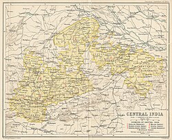
Map of the Central India Agency with the Bhopawar Agency located at its western end
Area 
 1901
19,902 km2 (7,684 sq mi)
Population 
 1901
547546
History
History 
 Merger of Bhil Agency and Bhil Sub-agency
1882
 Merger into Malwa Agency
1937
Preceded by
Succeeded by
British Raj Red Ensign.svg Bhil Agency
Malwa Agency British Raj Red Ensign.svg
Wikisource-logo.svg This article incorporates text from a publication now in the public domain: Chisholm, Hugh, ed. (1911). "Bhopawar". Encyclopædia Britannica (11th ed.). Cambridge University Press.

Bhopawar Agency was a sub-agency of the Central India Agency in British India with the headquarters at the town of Bhopawar, so the name. Bhopawar Agency was created in 1882 from a number of princely states in the Western Nimar and Southern Malwa regions of Central India belonging to the former Bhil Agency and Bhil Sub-agency with the capitals at Bhopawar and Manpur. [1] The agency was named after Bhopawar, a village in Sardarpur tehsil, Dhar District of present-day Madhya Pradesh state. Manpur remained a strictly British territory.

Contents

The other chief towns of this region were: Badnawar, Kukshi, Manawar and Sardarpur, Chadawad Estate, Dattigaon. The mighty Vindhya and Satpura ranges crossed the territory of the agency roughly from east to west, with the fertile valley of the Narmada River lying between them. The agency also included the "Bhil Country", inhabited by the Bhil people. [2]

History

At the time of its 1882 establishment, the agency had a total area of 7,684 square miles (19,900 km2), and its population was 547,546 according to the 1901 census. In 1904 certain districts were transferred from this agency to the Indore Residency, created in 1899, and the area of Bhopawar was thus reduced by 3,283 square miles (8,500 km2). [3]

In 1925 Bhopawar Agency was merged into Malwa Agency, and in 1927 the agency was renamed the Malwa-Bhopawar States Agency, which was renamed again as the Malwa Agency in 1934.

After Indian Independence in 1947, the rulers of the princely states within Malwa-Bhopawar Agency acceded to the Union of India, and the region became part of the new state of Madhya Bharat. Madhya Bharat was merged into Madhya Pradesh on 1 November 1956.

Princely states and their feudatory estates

Bhopawar Agency Information Bhopawar Agency States and estates.jpg
Bhopawar Agency Information

Salute States

Salute states in the agency, by precedence, with their feudatories :

  1. Dhar, title Maharaja, Hereditary salute of 15-guns
  2. Alirajpur, title Raja, Hereditary salute of 11-guns
    • including the extinct State of Phulmaal, which was incorporated into it earlier as well as Fiefs (Jagirs)
    1. Ondhwa
    2. Sondhwa.
  3. Barwani, title Maharana, Hereditary salute of 11-guns
  4. Jhabua, title Raja, Hereditary salute of 11-guns (till 1927, later shifted to (Malwa Agency)

Non-salute states

Minor and petty Princely states in the agency included (alphabetically, with their feudatories) :

  1. Amjhera, title Rao
  2. Bakhatgarh
  3. Chhadawad, title Rao
  4. Jobat, title Raja
  5. Kathiwara, title Thakur
  6. Mathwar, title Rana
  7. Multhan.
  8. Ratanmal, title Thakur.
  9. in Indore State Territory's few enclaves like - Petlawad Tehsil, Dahi Jagir, jamnia songaras raja etc.
  10. also including around about seventeen Feudal lords (Jagirdars) who paid direct tribute (nazarana/khillat) to Indore Durbar .

Further estates, not named above, include :

Related Research Articles

Central Provinces and Berar Province of British India, and later, Dominion of India (1903–1950)

The Central Provinces and Berar was a province of British India and later the Dominion of India which existed from 1903 to 1950. It was formed by the merger of the Central Provinces with the province of Berar, which was territory leased by the British from the Hyderabad State. Through an agreement signed on 5 November 1902, 6th Nizam Mahbub Ali Khan, Asaf Jah VI leased Berar permanently to the British for an annual payment of 25 lakhs Rupees. Lord Curzon decided to merge Berar with the Central Provinces, and this was proclaimed on 17 September 1903.

Central India Agency Government agency in British India

The Central India Agency was created in 1854, by amalgamating the Western Malwa Agency with other smaller political offices which formerly reported to the Governor-General of India. The agency was overseen by a political agent who maintained British relations with the princely states and influence over them on behalf of the Governor-General. The headquarters of the agent were at Indore.

Dhar Place in Madhya Pradesh, India

Dhar is a city located in Dhar district of the Malwa region in the state of Madhya Pradesh, India. The city is the administrative headquarters of the Dhar district. Before Indian independence from Great Britain, it was the capital of the Dhar princely state.

Jhabua Town in Madhya Pradesh, India

Jhabua is a town and a municipality in Jhabua district in the Indian state of Madhya Pradesh. It is the administrative headquarters of Jhabua District.

Khargone district District of Madhya Pradesh in India

Khargone district, formerly known as West Nimar district, is a district of Madhya Pradesh state in central India. The district lies in Nimar region, and is part of Indore Division. Khargone city is the headquarters of this district which lies south to Indore, metropolis and headquarters of Indore District.

The Hill States of India were princely states lying in the northern border regions of the British Indian Empire.

Bhopal Agency

The Bhopal Agency was a section of British India's colonial Central India Agency, a British political unit which managed the relations of the British with a number of autonomous princely states existing outside British India.

Eastern States Agency

The Eastern States Agency was a grouping of princely states in eastern India, during the latter years of Britain's Indian Empire. It was created in 1933, by the unification of the former Chhattisgarh States Agency and the Orissa States Agency; the agencies remained intact within the grouping. In 1936, the Bengal States Agency was added.

Malwa Agency was an administrative section of British India's Central India Agency. The headquarters of the political agent was at Mandsaur (Mandasor) / Neemuch (Nimach). The other chief towns of the region were : Ratlam and Jaora.

Sardarpur City in Madhya Pradesh, India

Sardarpur is a town and a nagar panchayat in Dhar district in the Indian state of Madhya Pradesh. It is a town on Mahi river on the Malwa plateau. There is an ancient Shivalinga situated at the bank of Mahi river at a place called Shree Jhineshwar Dham; Shri Mohankheda Jain Thirth and Bhopawar Jain Tirth are located nearby.

Bundelkhand Agency

The Bundelkhand Agency was a political agency of the British Raj, managing the relations of the British government with the protected princely states of the Bundelkhand region.

Gwalior Residency Gwalior State political office

Gwalior Residency was a political office in the British Indian Empire, which existed from 1782 until the British withdrawal from India in 1947.

Bhilala

A bhilala rajput tribe found in the Malwa and Nimar of the Central Provinces and in Central India. The total strength of the Bhilalas is about 150,000 persons, most of whom reside in the Bhopawar Agency, adjoining Nimar. Only 15,000 were returned from the Central Provinces in 1911. The Bhilalas are commonly considered, and the general belief may in their case be accepted as correct, to be a mixed caste sprung from the alliances of immigrant Rajputs with the Bhils of the Central India hills. The original term was not improbably Bhilwala, and may have been applied to those Rajput chiefs, a numerous body, who acquired small estates in the Bhil country, or to those who took the daughters of Bhil chieftains to wife. The bhilalas in the central province are descendants from alliances of Rajput with Bhils and take the name of the Rajput clan to which they trace their origin. The bhilalas are landholders and live like mukhhiyas, darbar or thakur. Jhabua are said to be under a bhilala ruler until independence.

Dhar State

Dhar State was a princely state of British Raj. It was a salute state in the colonial sway of the Central India Agency. Dhar began as one of the states during Maratha dominance in India about 1730. In 1941 it had an area of 1,798 square miles (4,660 km2) and a population of 253,210. Dhar (anagar) was the capital of the state since 1732 (from the 1728 foundation, the Raja's first seat had been Malthan/Multhan. In 1948, it became part of Madhya Bharat.

Narsinghgarh State

Narsinghgarh State is a former princely state of the British Raj in India. It formed an enclave within Rajgarh State and was placed administratively under the Bhopal Agency subdivision of the Central India Agency. The state covered an area of 1,920 square kilometres (740 sq mi) and had a population of 92,093 and an average revenue of Rs.5,00,000 in 1901.

Sailana State

Sailana State was an 11 gun salute princely state in India, part of the Malwa Agency of Central India during the British Raj. The state enjoyed an estimated revenue of Rs.5,00,000.

Rajgarh State

Rajgarh State was a princely state in India, named after its capital Rajgarh, Madhya Pradesh. It was part of the colonial Bhopal Agency of the Central India Agency during the British Raj. It lay in the region of Malwa known as Umatwara after the ruling Umat clan, a branch of the Parmar Rajputs. The neighbouring Narsinghgarh State was ruled by a cadet branch of this family, after being partitioned in 1681.

Jhabua State

Jhabua State was one of the princely states of India during the period of the British Raj. It had its capital in Jhabua town. Most of the territory of the princely state was inhabited by the Bhil people, who constituted a majority of the population. The revenue of the state in 1901 was Rs.1,10,000.

Multhan is a village in a dhar district Madhya Pradesh.

References

  1. Great Britain India Office. The Imperial Gazetteer of India . Oxford: Clarendon Press, 1908.
  2. Imperial Gazetteer of India, v. 8, p. 145.
  3. Wikisource-logo.svg One or more of the preceding sentences incorporates text from a publication now in the public domain : Chisholm, Hugh, ed. (1911). "Bhopawar". Encyclopædia Britannica . Vol. 3 (11th ed.). Cambridge University Press. p. 846.

Coordinates: 22°55′N75°15′E / 22.917°N 75.250°E / 22.917; 75.250