Jobat State

Last updated

Jobat State
जोबत रियासत
Princely State
15th century–1948
Barwani-Dhar map.jpg
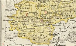
Jobat State in the Imperial Gazetteer of India
Area 
 1901
339 km2 (131 sq mi)
Population 
 1901
9,443
History 
 Established
15th century
1948
Succeeded by
India Flag of India.svg

Jobat State [1] was a princely state in India during the British Raj. It was placed administratively under the Bhopawar Agency [2] subdivision of the Central India Agency. The state covered an area of 339 square kilometres and had a population of 9.443 which produced an average revenue of Rs.21,000 in 1901. [3]

Jobat State and the Bhopawar Agency Bhopawar Agency States and estates.jpg
Jobat State and the Bhopawar Agency

Ranas

Related Research Articles

<span class="mw-page-title-main">Central India Agency</span> Agency of princely states in India

The Central India Agency was created in 1854, by amalgamating the Western Malwa Agency with other smaller political offices which formerly reported to the Governor-General of India. The agency was overseen by a political agent who maintained relations of the Government of India with the princely states and influence over them on behalf of the Governor-General. The headquarters of the agent were at Indore.

<span class="mw-page-title-main">Jhabua</span> Town in Madhya Pradesh, India

Jhabua is a town and a municipality in Jhabua district in the Indian state of Madhya Pradesh. It is the administrative headquarters of Jhabua District.

<span class="mw-page-title-main">Dholpur State</span> Historic Kingdom

Dhaulpur State or Dholpur State, historically known as the Kingdom of Dholpur, was a kingdom of eastern Rajasthan, India, which was founded in AD 1806 by a Jat ruler Rana Kirat Singh of Gohad. After 1818, the state was placed under the authority of British India's Jatwara. The Ranas ruled the state until the independence of India in 1947, when the kingdom was merged with the Union of India.

<span class="mw-page-title-main">Bhopawar Agency</span>

Bhopawar Agency was a sub-agency of the Central India Agency in British India with the headquarters at the town of Bhopawar, so the name. Bhopawar Agency was created in 1882 from a number of princely states in the Western Nimar and Southern Malwa regions of Central India belonging to the former Bhil Agency and Bhil Sub-agency with the capitals at Bhopawar and Manpur. The agency was named after Bhopawar, a village in Sardarpur tehsil, Dhar District of present-day Madhya Pradesh state. Manpur remained a strictly British territory.

Malwa Agency was an administrative section of British India's Central India Agency. The headquarters of the political agent was at Neemuch (Nimach). The other chief towns of the region were : Ratlam and Jaora.

Jobat is a city and a nagar parishad municipality in Alirajpur district in the Indian state of Madhya Pradesh.

<span class="mw-page-title-main">Agencies of British India</span> Fully- or semi-autonomous administrative region of British India

An agency of British India was an internally autonomous or semi-autonomous unit of British India whose external affairs were governed by an agent designated by the Viceroy of India.

<span class="mw-page-title-main">Idar State</span> Former princely state in India

Idar State, also known as Edar, was a princely state located in present-day Gujarat state of India. During the British era, it was a part of the Mahi Kantha Agency, within the Gujarat Division of Bombay Presidency.

<span class="mw-page-title-main">Orchha State</span> Princely state of India

Orchha State was a kingdom situated in the Bundelkhand region and later a princely state in British India. The state was ruled by Bundela clan of Rajputs. It was located within what is now the state of Madhya Pradesh.

<span class="mw-page-title-main">Alirajpur State</span> Princely state of India

Alirajpur State was formerly a princely state of India, administratively under the Bhopawar Agency subdivision of the Central India Agency. The state covered an area of 2165 square kilometres, with a population of 50,185 in 1901 and its capital at Alirajpur. The average revenue of the state was Rs.100,000 in 1901.

<span class="mw-page-title-main">Khilchipur State</span> Princely state of India

Khilchipur State was a 9 gun salute princely state in India. The seat was in Khilchipur. It had an area of 710 square kilometres (273 sq mi), and a population of 31,143 in 1901. Its estimated revenue in 1901 was Rs.1,14,000.

<span class="mw-page-title-main">Alwar State</span> Princely state from 1770 to 1949

Alwar State is a princely state of Naruka Rajputs with its capital at Alwar in India. Founded in 1770 CE by Pratap Singh Prabhakar, its reigning ruler, Maharaja Sir Tej Singh Prabhakar Bahadur, signed the accession to the Indian Union on 7 April 1949.

<span class="mw-page-title-main">Piploda State</span>

Piploda State was an estate in India at the time of the British Raj. It belonged to the Malwa Agency, part of the Central India Agency. The state was initially a tributary of Jaora State. In 1924 Piploda became an independent non-gun salute state through British mediation.

<span class="mw-page-title-main">Barwani State</span> Princely state of India

Barwani State was a princely state in India. It is ruled by Sisodiya rajput. The seat was at Barwani.

<span class="mw-page-title-main">Shahpura State</span> Former Indian princely state

The State of Shahpura or Princely State of Shahpura was a princely state in Shahpura, Bhilwara during the era of British India. Its relations with the British were managed by the Rajputana Agency. The last ruler of Shahpura signed the accession to join the Indian Union in 1949.

<span class="mw-page-title-main">Jammu</span> City in Indian-administered Jammu and Kashmir

Jammu is a city in Indian-administered Jammu and Kashmir in the disputed Kashmir region. It is the winter capital of Jammu and Kashmir, which is an Indian-administered union territory. It is the headquarters and the largest city in Jammu district. Lying on the banks of the river Tawi, the city of Jammu, with an area of 240 km2 (93 sq mi), is surrounded by the Himalayas in the north and the northern plains in the south. Jammu is the second-most populous city of the union territory. Jammu is known as "City of Temples" for its ancient temples and Hindu shrines.

<span class="mw-page-title-main">Nagod State</span> State in British India

Nagod State was a princely state of colonial India, located in modern Satna district of Madhya Pradesh. The state was known as 'Unchahara' after Unchehara, its original capital until the 18th century.

<span class="mw-page-title-main">Sonepur State</span> Former princely state of British India

Sonepur, also known as Sonpur State, was one of the princely states of India during the period of the British Raj. Its ruler was entitled to a nine gun salute. Formerly it was placed under the Central India Agency, but in 1905 it was transferred to the Eastern States Agency. Its capital was Sonepur, the only significant town in the area. The former state's territory is in the present-day Subarnapur district, Odisha.

<span class="mw-page-title-main">Lunavada State</span> Princely state of India

Lunavada State, also known as Lunawada State, was a princely state in India during the time of the British Raj. Its last ruler acceded to the Union of India on 10 June 1948.

<span class="mw-page-title-main">Jhabua State</span> Princely state of India

Jhabua State was one of the princely states of India during the period of the British Raj. It had its capital in Jhabua town. Most of the territory of the princely state was inhabited by the Bhil people, who constituted a majority of the population. The revenue of the state in 1901 was Rs.1,10,000.

References

  1. Imperial Gazeteer of India, v. 5, p. 223.
  2. Chisholm, Hugh, ed. (1911). "Bhopawar"  . Encyclopædia Britannica . Vol. 3 (11th ed.). Cambridge University Press. p. 846.
  3. "Imperial Gazetteer2 of India, Volume 8, page 147 -- Imperial Gazetteer of India -- Digital South Asia Library".

22°25′N74°34′E / 22.42°N 74.57°E / 22.42; 74.57