Gaurihar State

Last updated

Gaurihar State
Princely State
1807–1950
JaitpurKart.jpg
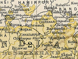
Gaurihar State in the Imperial Gazetteer of India
Area 
 1901
184 km2 (71 sq mi)
Population 
 1901
7760
History
History 
 Established
1807
1950
Succeeded by
India Flag of India.svg
Today part ofFlag of India.svg  India
Malleson, G. B.: An historical sketch of the native states of India, London 1875, Reprint Delhi 1984

Gaurihar State was a princely state in India, ruling a territory that is now in Madhya Pradesh. [1] Gaurihar is a tehsil of Chhatarpur district. [2]

Contents

History

This family is descended from Raja Ram Tiwari, who was Governor of a fort in the service of Guman Singh , ancestor of the Maharajas of Ajaigarh . During the anarchy of the times , Raja Ram rebelled and for a short while held the fort successfully against Ali Bahadur I Gaurihar was Kanykubj Brahmin of Jhujautiya division Tiwari ruling state. [3] Gaurihar state was founded in 1807 after a split from Ajaigarh State. Pratap Singh Judev signed the accession to the Indian Union on 1 January 1950. Maharaja Chandra Bhan Singh Judev was the last ruler of Gaurihar state.[ citation needed ]

Rulers

The rulers bore the title 'Sardar Sawai' and from 1859 the title 'Rao'. [4]

Related Research Articles

Ajaigarh or Ajaygarh is a town and a nagar panchayat in the Panna District of Madhya Pradesh state in central India.

<span class="mw-page-title-main">Vindhya Pradesh</span> Former State of India

Vindhya Pradesh was a former state of India. It occupied an area of 61,131.5 km2. It was created in 1948 as Union of Baghelkhand and Bundelkhand States, shortly after Indian independence, from the territories of the princely states in the eastern portion of the former Central India Agency. It was named as Vindhya Pradesh on 25 January 1950 after the Vindhya Range, which runs through the centre of the province. The capital of the state was the former princely state of Rewa. It lays between Uttar Pradesh to the north and Madhya Pradesh to the south, and the enclave of Datia, which lay a short distance to the west, was surrounded by the state of Madhya Bharat.

<span class="mw-page-title-main">Central India Agency</span> Agency of princely states in India

The Central India Agency was created in 1854, by amalgamating the Western Malwa Agency with other smaller political offices which formerly reported to the Governor-General of India. The agency was overseen by a political agent who maintained relations of the Government of India with the princely states and influence over them on behalf of the Governor-General. The headquarters of the agent were at Indore.

<span class="mw-page-title-main">Bundelkhand Agency</span>

The Bundelkhand Agency was a political agency of the British Raj, managing the relations of the British government with the protected princely states of the Bundelkhand region.

<span class="mw-page-title-main">Dhenkanal State</span> Princely state in Odisha, India

Dhenkanal State was one of the princely states of India during the period of the British Raj. The state is now referred to as Dhenkanal district, Odisha, with Dhenkanal town as its district headquarters.

<span class="mw-page-title-main">Alipura State</span> Princely state in the Indian state of Madhya Pradesh

Alipura was a princely state in what is today the Chhatarpur District in the Indian state of Madhya Pradesh.

<span class="mw-page-title-main">Baraundha</span>

Baraundha was a princely state of colonial India, located in modern Satna district of Madhya Pradesh. Although historically far larger, at the time of Indian independence in 1950, it was a saluted state of 9 guns.

<span class="mw-page-title-main">Alirajpur State</span> Princely state of India

Alirajpur State was formerly a princely state of India, administratively under the Bhopawar Agency subdivision of the Central India Agency. The state covered an area of 2165 square kilometres, with a population of 50,185 in 1901 and its capital at Alirajpur. The average revenue of the state was Rs.100,000 in 1901.

<span class="mw-page-title-main">Chamba State</span> One of the oldest princely states in present-day Republic of India

Chamba State was one of the oldest princely states in present-day Republic of India, having been founded during the late 6th century. It was part of the States of the Punjab Hills of the Punjab Province in India from 1859 to 1947. Its last ruler signed the instrument of accession to the Indian Union of 15 April 1948.

<span class="mw-page-title-main">Bikaner State</span> Princely state of India

Bikaner State was a princely state in the Rajputana from 1465 to 1947. The founder of the state, Rao Bika, was the eldest son of Rao Jodha, ruler of Jodhpur. Rao Bika chose to build his own kingdom instead of inheriting his father's. Bika defeated the Jat clans of Jangladesh along with his uncle Rao Kandhal and his adviser Vikramji Rajpurohit and founded his own kingdom. Its capital was the city of Bikaner in the northern area of present-day Rajasthan State in India. Karni Mata has been designated as the kuldevi of the Royal family of Bikaner.

<span class="mw-page-title-main">Jaso State</span>

Jaso or Jassu, formerly known as Yashogarh was a princely state of the Bundelkhand Agency in British India located in present-day Nagod tehsil, Satna district, Madhya Pradesh. It was surrounded in the north, east and south by Nagod State and in the east by Ajaigarh.

<span class="mw-page-title-main">Chhatarpur State</span> Princely state of India

Chhatarpur was one of the princely states of India during the period of the British Raj. The state was founded in 1785 and its capital was located in Chhatarpur, Madhya Pradesh.

<span class="mw-page-title-main">Ajaigarh State</span> Former Indian state

Ajaigarh State was one of the princely states of India during the period of the British Raj. The state was ruled by Bundela clan of Rajput. The state was founded in 1765 by Guman Singh and its capital was located in Ajaigarh, Madhya Pradesh. Ajaigarh's last ruler signed the accession to the Indian Union on 1 January 1950.

<span class="mw-page-title-main">Udaipur State, Chhattisgarh</span>

Udaipur State was one of the princely states of India during the period of the British Raj. The town of Dharamjaigarh was the former state's capital.

<span class="mw-page-title-main">Kharsawan State</span> Princely state of the British Raj

Kharsawan State, also spelt Kharsua or kharaswan, (Odia:ଖରସୁଆଁ)was a princely state in India during the era of the British Raj. The state had a privy purse of 33,000 Rs.It was one of the Odia Princely states of India during the period of the British Raj and the major language spoken in the area is Odia.

<span class="mw-page-title-main">Panna State</span> Princely state of India

Panna State was a princely state of colonial India, located in modern Panna district of Madhya Pradesh.

<span class="mw-page-title-main">Surguja State</span> Princely state of Central India

Surguja State was one of the main princely states of Central India during the period of the British Raj, even though it was not entitled to any gun salute. Formerly it was placed under the Central India Agency, but in 1905 it was transferred to the Eastern States Agency.

References

  1. Henige, David P. (2004). Princely states of India: a guide to chronology and rulers. Orchid Press. p. 67. ISBN   9789745240490.
  2. "Chhatarpur Tehsil Map, Chhatarpur Tehsil List". MapsofIndia.com. Retrieved 13 October 2013.
  3. The Chiefs of Central India
  4. Princely States of India A-J

25°17′44″N80°10′29″E / 25.29556°N 80.17472°E / 25.29556; 80.17472