Ajaigarh or Ajaygarh is a town and a nagar panchayat in the Panna District of Madhya Pradesh state in central India.

The Central India Agency was created in 1854, by amalgamating the Western Malwa Agency with other smaller political offices which formerly reported to the Governor-General of India. The agency was overseen by a political agent who maintained relations of the Government of India with the princely states and influence over them on behalf of the Governor-General. The headquarters of the agent were at Indore.

Panna is a city and a municipality in Panna district in the Indian state of Madhya Pradesh. It is famous for its diamond mines and temples. It is the administrative center of Panna District.

Satna is a city in the Indian state of Madhya Pradesh. It serves as the headquarters of Satna district. It is 7th largest city and 8th most populous city of the state. The city is 500 km east of the state capital Bhopal. The city is distributed over a land area of 111.9 square kilometres.
Bijawar is a city the state of Madhya Pradesh, India. It is the administrative headquarters of Bijawar Taluk, and was formerly the capital of a princely state of British India of the same name. The people of Bijawar are demanding the district status from their state government. It is the 53rd proposed district of Madhya Pradesh

Kulpahar is a city in Mahoba district in the Indian state of Uttar Pradesh. It is a historical town in the Bundelkhand region. Before 11 Feb 1995 Kulpahar was a Tehsil of Hamirpur District. On 11 Feb 1995 Mahoba District was carved out of Hamirpur, and Kulpahar is now a part of the Mahoba District. Kulpahar is the largest Subdivision of Uttar Pradesh. Kulpahar is known for its closeness to Khajuraho and other historic places like Mahoba, Charkhari, Kalinjar Rath, Orchha, and Jhansi. This town holds relics of temples and man-made water bodies of the Chandela Dynasty
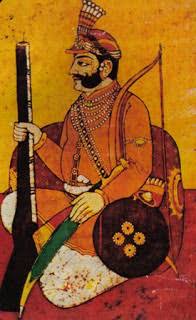
Chhatrasal Bundela was the Raja of Panna from 1675 to 1731. He is well known for his resistance against the Mughal Empire.

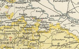
The Bundelkhand Agency was a political agency of the British Raj, managing the relations of the British government with the protected princely states of the Bundelkhand region.

Rewa State, also known as Rewah, was a kingdom and later princely state of India, surrounding its eponymous capital, the town of Rewa.
Sarila is a town, a former princely state and a nagar panchayat in Hamirpur district in the northern Indian state of Uttar Pradesh.

Orchha State was a kingdom situated in the Bundelkhand region and later a princely state in British India. The state was ruled by Bundela clan of Rajputs. It was located within what is now the state of Madhya Pradesh.

Sailana State was an 11 gun salute princely state in India, part of the Malwa Agency of Central India during the British Raj. The state enjoyed an estimated revenue of Rs.5,00,000.
Paldeo, also spelt 'Paldev', was a princely estate (Jagir) in India during the British Raj. It was under the Bundelkhand Agency of the Central India Agency until 1896 when it was transferred to the Baghelkhand Agency. In 1931 it was transferred back to the Bundelkhand Agency. It had an area of 52 square miles. In 1940 its population was 9,820 distributed in 18 villages. Paldeo Estate was merged into the Indian state of Vindhya Pradesh in 1948.

Khaniadhana or Khaniyadhana was a princely state of British India ruled by the Judev dynasty of Bundela Rajputs. The capital of the State was Khaniadhana. It was part of the Bundelkhand Agency and later the Central India Agency.

Chhatarpur was one of the princely states of India during the period of the British Raj. The state was founded in 1785 and its capital was located in Chhatarpur, Madhya Pradesh.

Charkhari State was one of the Princely states of India during the period of the British Raj. On India's independence, this Princely state acceded to India. Currently Charkhari town, the former state's capital, is a part of Uttar Pradesh state.

Bijawar State was a princely state of colonial India, located in modern Chhatarpur district of Madhya Pradesh.

Panna State was a kingdom and later princely state of colonial India, located in modern Panna district of Madhya Pradesh.

Jigni State was a princely state of the Bundelkhand Agency of the British Raj. It was a small Sanad state of about 82.87 km2 with a population of 4,297 inhabitants in 1901. The state was surrounded by the Hamirpur and Jhansi districts of the United Provinces.
