Charkhari State

Last updated

Charkhari State
Princely State of British India
1765–1947
Drapeau Charkhari.jpg
Flag
CoA Charkhari.png
Coat of arms
JaitpurKart.jpg
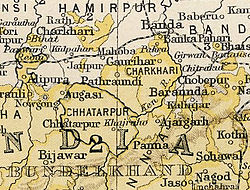
Charkhari State in the Imperial Gazetteer of India
Capital Charkhari
Area 
 1901
2,279 km2 (880 sq mi)
Population 
 1901
123,254
History 
 Established
1765
1947
Succeeded by
India Flag of India.svg

Charkhari State was one of the Princely states of India during the period of the British Raj. [1] On India's independence, this Princely state acceded to India. Currently Charkhari town, the former state's capital, is a part of Uttar Pradesh state.

Contents

History

Charkhari State was founded in 1765 by Khuman Singh. [2] Raja Chhatarsal divided his lands in 1731 into several portions, one of which was given to Raja Jagat Rai. At his death in 1757, a dispute arose as to the succession, with Raja Pahar Singh, seizing the territory forcing Raja Khuman Singh to flee. Terms were agreed to in 1764, and Raja Khuman Singh received Charkhari, becoming its first Raja in 1765. [3]

In 1857, Raja Ratan Singh received a hereditary salute of 11 guns, a khilat, and a perpetual jagir of Rs. 20,000 (£1,300) a year in recognition of his services during the Indian Mutiny. [4] [5]

The last ruler of this Princely state signed the accession to the Indian Union on 15 August 1947.

Rulers

In 1804, under Raja Bikramajit Singh (1782–1829) rule, the state became a British protectorate. [6]

NameArmsBirthReign FromReign UntilDeathNote
Khuman Singh CoA Charkhari.png 17651782
Bikramajit Singh (Vikramaditya or Vijay Bahadur Singh)17821829
Ratan Singh18291860
Jai Singh Deo18601880
Malkhan Singh Ju Deo18806 July 1908
Jujhar Singh Ju Deo6 July 19081914
Ganga Singh Ju Deo19145 October 1920
Arimardan Singh Ju Deo19208 November 1941
Jayendra Singh Ju Deo8 November 194115 August 19471977Due to 26th Amendment to the Constitution of India, he ceased to enjoy his princely pensions, titles, and privileges.
Jayant Singh Ju Deo1977 Pretender

See also

Related Research Articles

Ajaigarh or Ajaygarh is a town and a nagar panchayat in the Panna District of Madhya Pradesh state in central India.

Charkhari is a city in Mahoba district in the state of Uttar Pradesh, India. This is the Kashmir of Bundelkhand. It was the capital of the Charkhari concession. There are lakes named Vijay Sagar, Malkhan Sagar, Vanshi Sagar, Jai Sagar, Ratan Sagar and Kothi Tal. There are 108 temples of Krishna giving the nature and beauty of Vraj to Charkhari city. In which Gopal Bihari temple of Sudamapuri, Guman Bihari of Ryanpur, temple of Mangalgarh, Bakht Bihari, temple of Banke Bihari and cave of Madavya Rishi are there. It is also the headquarters of Charkhari Tehsil and the name of Legislative Assembly seat is also Charkhari. Legislative Assembly constituency.

<span class="mw-page-title-main">Bundelkhand Agency</span>

The Bundelkhand Agency was a political agency of the British Raj, managing the relations of the British government with the protected princely states of the Bundelkhand region.

<span class="mw-page-title-main">Rewa (princely state)</span> Princely state in India

Rewa State, also known as Rewah, was a Rajput princely state of India, surrounding its eponymous capital, the town of Rewa.

Sarila is a town, a former princely state and a nagar panchayat in Hamirpur district in the northern Indian state of Uttar Pradesh.

<span class="mw-page-title-main">Dhar State</span> Princely state in present-day India

Dhar State was a princely state. It was a salute state in the colonial sway of the Central India Agency. Dhar began as one of the states during Maratha dominance in India about 1730. In 1941 it had an area of 1,798 square miles (4,660 km2) and a population of 253,210. Dhar was the capital of the state since 1732 (from the 1728 foundation, the Raja's first seat had been at Multhan in Dhar district. In 1948, it became part of Madhya Bharat.

<span class="mw-page-title-main">Alipura State</span> Princely state in the Indian state of Madhya Pradesh

Alipura was a princely state in what is today the Chhatarpur District in the Indian state of Madhya Pradesh.

<span class="mw-page-title-main">Narsinghgarh State</span> Princely state of India

Narsinghgarh State is a former princely state of the British Raj in India. It formed an enclave within Rajgarh State and was placed administratively under the Bhopal Agency subdivision of the Central India Agency. The state covered an area of 1,920 square kilometres (740 sq mi) and had a population of 92,093 and an average revenue of Rs.5,00,000 in 1901.

<span class="mw-page-title-main">Bundi State</span> Princely state of India

Bundi State was founded by Hada Rao Devda currently located in modern-day Rajasthan. It was ruled by Hada Chauhans Rajputs.

<span class="mw-page-title-main">Sakti State</span>

Sakti State was one of the princely states of India during the British Raj. It belonged to the Chhattisgarh States Agency, which later became the Eastern States Agency.

<span class="mw-page-title-main">Sitamau State</span> Princely state of India

Sitamau State was a princely state of the British Raj before 1947. Its capital was in Sitamau town, Mandsaur district, Madhya Pradesh. The total area of the state was 350 square miles. The average revenue of the state was Rs.130,000.

<span class="mw-page-title-main">Kishangarh State</span> Princely state in India (1611–1947)

Kishangarh State was a princely state of India from 1611 to 1948. It was founded by the Jodhpur prince Kishan Singh in 1609. Before Kishan Singh this area was ruled by Raja Samokhan Singh.

<span class="mw-page-title-main">Raigarh State</span> Indian princely state during the British Raj

Raigarh was a princely state in India at the time of the British Raj. The state was ruled by a Gond dynasty of Gond clan.

<span class="mw-page-title-main">Chhatarpur State</span> Princely state of India

Chhatarpur was one of the princely states of India during the period of the British Raj. The state was founded in 1785 and its capital was located in Chhatarpur, Madhya Pradesh.

<span class="mw-page-title-main">Udaipur State, Chhattisgarh</span>

Udaipur State was one of the princely states of India during the period of the British Raj. The town of Dharamjaigarh was the former state's capital.

<span class="mw-page-title-main">Bijawar State</span> Princely state of colonial India

Bijawar State was a princely state of colonial India, located in modern Chhatarpur district of Madhya Pradesh.

<span class="mw-page-title-main">Panna State</span> Princely state of India

Panna State was a princely state of colonial India, located in modern Panna district of Madhya Pradesh.

<span class="mw-page-title-main">Jhabua State</span> Princely state of India

Jhabua State was one of the princely states of India during the period of the British Raj. It had its capital in Jhabua town. Most of the territory of the princely state was inhabited by the Bhil people, who constituted a majority of the population. The revenue of the state in 1901 was Rs.1,10,000.

<span class="mw-page-title-main">Narsinghpur State</span> Princely state of India before 1948

Narsinghpur State was one of the princely states of India during the period of the British Raj. The state was founded in the 17th century and had its capital in Narasinghpur town. The last ruler of Narsinghpur joined the state to the Indian Union in 1948 and Narsinghpur state was made part of the Cuttack district of Odisha.

<span class="mw-page-title-main">Jaitpur State</span>

Jaitpur State was a princely state in the Bundelkhand region. It was centered on Jaitpur, in present-day Mahoba district, Uttar Pradesh, which was the capital of the state. There were two forts in the area.

References

  1. Princely States of India A-J
  2. "Charkhari". Archived from the original on 27 August 2019. Retrieved 2 February 2017.
  3. "History and founding of Charkhari - indianrajputs". 23 May 1952.
  4. Kruse, Paul Robert (1910). The Encyclopædia Britannica: A Dictionary of Arts, Sciences, Literature and General Information. At the University Press.
  5. Commissioner, India Census (1902). Census of India, 1901: Central India (3 v.). Office of the Superintendent of Government Printing, India.
  6. States before 1947


25°24′N79°45′E / 25.4°N 79.75°E / 25.4; 79.75