Khairpur (princely state)

Last updated

Khairpur state
ریاست خیرپور
1783–30 September 1955
Khairpurflag.png
Flag
Khairpur map.gif
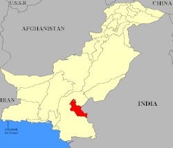
Khairpur (highlighted red) shown within the former exclave of West Pakistan
Status Princely state under British Raj(1838-1947)
Princely state of Pakistan (1947-1955)
Capital Khairpur
Common languages Sindhi
Religion
Islam
Government Absolute Monarchy
Mir  
 1783–1811
Mir Sohrab Khan Talpur (first)
 1947–1954
George Ali Murad Khan Talpur II (last)
History 
1783
17 February – 24 March 1843
  Princely State established
c.1853
3 October 1947
30 September 1955
Area
 Total
15,730 km2 (6,070 sq mi)
Preceded by
Succeeded by
Flag of Talpur dynasty.gif Sind State
Blank.png Talpur dynasty
Dominion of Pakistan Blank.png
Today part of

The State of Khairpur (also transliterated as Khayrpur) [1] was a princely state of British India on the Indus River in northern Sindh, modern Pakistan, with its capital city at Khairpur.

Contents

History

Khairpur was established by the Talpur dynasty of the Balochs in 1783. Conquered by the British in 1843 following the Battle of Miani, Mir Sher Muhammad Talpur eventually gave up attempts to regain control of the area after a decade and entered into treaty with the British, thereby maintaining some autonomy as a princely state. The last Mir of Khairpur opted to join the new state of Pakistan in 1947, and the dominion was thus made a princely state of Pakistan, until it was fully amalgamated into West Pakistan in 1955. [2]

Khairpur State in a map of Bombay, Sind, Baroda, and states of Western India (northern section), published in the 'Imperial Gazetteer of India' (Vol. XXVI, Atlas; 1931 revised edition; plate no. 38) Map of Bombay, Sind, Baroda, and states of Western India (northern section), published in the 'Imperial Gazetteer of India' (Vol. XXVI, Atlas; 1931 revised edition; plate no. 38).jpg
Khairpur State in a map of Bombay, Sind, Baroda, and states of Western India (northern section), published in the 'Imperial Gazetteer of India' (Vol. XXVI, Atlas; 1931 revised edition; plate no. 38)
The Faiz Mahal haveli was one of several palaces used by the Khaipur Talpur Mirs. Faiz Mahal Khairpur Sindh.jpg
The Faiz Mahal haveli was one of several palaces used by the Khaipur Talpur Mirs.

See also

References

  1. "Imperial Gazetteer2 of India, Volume 3, page 336 -- Imperial Gazetteer of India -- Digital South Asia Library". dsal.uchicago.edu. Archived from the original on 4 March 2016. Retrieved 5 August 2011.
  2. "Khairpur: then and now - Daily Times". Daily Times. 6 February 2018. Archived from the original on 8 October 2019. Retrieved 16 May 2018.

27°19′N68°28′E / 27.317°N 68.467°E / 27.317; 68.467