Dhrol State

Last updated

The State of Dhrol
ધ્રોલ રિયાસત
Princely State of British India
1595–1948
Dhrol flag.png
Flag
Dhrol coa.png
Coat of arms
SaurashtraKart.jpg
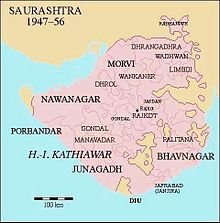
Location of Dhrol State in Saurashtra
CapitalDhrol
Area 
 1901
732 km2 (283 sq mi)
Population 
 1901
21,906
History 
 Established
1595
15 February 1948
Preceded by
Succeeded by
Flag of Nawanagar.png Nawanagar State
India Flag of India.svg
Today part of Saurashtra, India

Dhrol State was one of the 562 princely states of British India. It was a 9 gun salute state belonging to the Kathiawar Agency of the Bombay Presidency. [1] Its capital was in the town of Dhrol, located in the historical Halar region of Kathiawar.

Contents

History

Dhrol State was founded in 1595 by Jam Hardholji, a brother of Jam Rawal, the founder of Nawanagar State. The royal family belonged to the Jadeja clan of Rajputs who are the descendants of Samma tribe of Sindh . [2] The Khirasra state was an offshoot of Dhrol. [3] [4]

Dhrol State became a British protectorate in 1807. The population of the state was decimated by the Indian famine of 1899–1900, from 27,007 in 1891 it was reduced to 21,906 in the 1901 census. The last ruler of Dhrol State, Thakur Sahib Chandrasinhji Dipsinhji, signed the accession to the Indian Union on 15 February 1948.[ citation needed ]

Rulers

The rulers of the state bore the title 'Thakore Saheb'. They had the right to a 9 gun salute. [5] [6]

Rulers

See also

References

  1. "Dhrol State – Princely State (9 gun salute)". Archived from the original on 28 May 2018. Retrieved 20 September 2014.
  2. "Imperial Gazetteer2 of India, Volume 11, page 335 – Imperial Gazetteer of India – Digital South Asia Library". dsal.uchicago.edu. Retrieved 17 August 2019.
  3. "Princely States of India". Archived from the original on 13 January 2013. Retrieved 4 March 2025.
  4. "Khirasra: Princely State". Indian Rajputs. Indian Rajputs. 7 September 1918. Archived from the original on 24 January 2025. Retrieved 4 March 2025.
  5. "Indian Princely States before 1947 A-J". www.worldstatesmen.org. Archived from the original on 20 May 2013. Retrieved 17 August 2019.
  6. "Indian states before 1947 A-J". rulers.org. Archived from the original on 15 July 2015. Retrieved 17 August 2019.

22°34′N70°24′E / 22.567°N 70.400°E / 22.567; 70.400