
East Hanover Township is a township in Dauphin County, Pennsylvania, United States. The population was 5,718 at the 2010 census.

Kadayanallur is the largest city in Tenkasi district, Tamil Nadu, India. Kadyanallur is 18 km from Tenkasi.
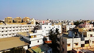
Kavali is a City in Nellore district of Andhra Pradesh of India. It is also known as Kanakapatnam, because it is home to many wealthy individuals and due to the prophecy from Potuluri Veerabrahmendra Swami, 'Wealth will flow into this place.' It is one of the few cities from Andhra Pradesh which were selected for Atal Mission for Rejuvenation and Urban Transformation (AMRUT) Scheme.

Tadepalligudem (TPG) is a city in West Godavari district of the Indian state of Andhra Pradesh. It is a Selection Grade municipality and the mandal headquarters of Tadepalligudem mandal in Eluru revenue division. Tadepalligudem is one of the largest City and fastest growing City in west godavari District as per 2011 census in terms of population.

Baran district is a district in the Indian state of Rajasthan. The headquarters of the district are located at the city of Baran.

Machhlishahr is a town in Jaunpur district in the Indian state of Uttar Pradesh. It is situated 30 km west of district headquarters Jaunpur. NH-231 passes through the city. Machhlishahr – Janghai – Bhadohi four-lane highway is under construction which will boost the economy of the region. Machhlishahr is a Nagar panchayat and there has been a longstanding demand for making it a Nagar palika parishad. In 2020, Machhalisahar nagar panchayat has secured 33rd all India rank in Swachh Survekshan cleanliness survey.

Upleta is a city and tehsil in the Rajkot district of the state of Gujarat, India. It contains within it two towns and 49 villages.
Bigwani Shumali is a town and union council of Dera Ismail Khan District in Khyber-Pakhtunkhwa province of Pakistan. It is located at 32°7'60N 71°1'0E and has an altitude of 169 metres. Muhammad Rustam Malana is the councler of Bigwani Shumali and Malik Rehmatullah is the Nazim of Bigwani Shumali.
Kotki or Kotki Bala is a town and union council of Hangu District in Khyber Pakhtunkhwa province of Pakistan. It is located at 33°28'0N 71°1'0E and has an altitude of 1011 metres.

Drążkowo is a settlement in the administrative district of Gmina Czarna Dąbrówka, within Bytów County, Pomeranian Voivodeship, in northern Poland. It lies approximately 7 kilometres (4 mi) north of Czarna Dąbrówka, 32 km (20 mi) north of Bytów, and 71 km (44 mi) west of the regional capital Gdańsk.

Daru-Kharika is a village in the Daru CD block in the Hazaribagh Sadar subdivision of the Hazaribagh district in Jharkhand state of India.

Khanbal is a town in Kupwara district, Jammu and Kashmir, India.

Mohammadpur is a village in the East Champaran district of Bihar state, India, located at 26°37′0″N85°11′0″E. National Highway 101 ends in Mohammadpur. The nearest airport is Patna Airport. There are a large number of institutes, including English medium schools, Government schools, and coaching centres, located here.

Kistaram is a town in Khammam district, Telangana, India.
Kalasapakkam is a state assembly constituency in Tiruvannamalai district of Tamil Nadu, India. It comprises portions of the Polur and Chengam taluks and is a part of the Tiruvannamalai constituency for national elections to the Parliament of India. Elections were not held in 1957 and 1962.
Tilsahari is a town in Kanpur district in the state of Uttar Pradesh, India. Nearby towns include Narwal and Maharajpur, 10 km north and 7 km west respectively.

Kehsi Mansam was a Shan state in what is today Burma. It belonged to the Eastern Division of the Southern Shan States. Its capital was Kehsi town, located by the Nam Heng River. The state included 378 villages and the population was mostly Shan, but there were also some Palaung people (Yins) in the area
Konstvägen sju älvar is a tourist and sculpture route in Västerbotten in North Sweden that travels 350 kilometers in from the coast.
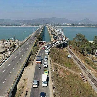
National Highway 27, an East - West National highway in India that starts from Porbandar and terminates in Silchar, the highway passes through the states of Gujarat, Rajasthan, Madhya Pradesh, Uttar Pradesh, Bihar, West Bengal, Assam. NH-27 was laid and is maintained by Ministry of Road Transport and Highways (MoRTH). This is the longest National Highway in India and is a part of NS-EW Corridor of NHAI.

Padgampora is a village in Awantipora tehsil in Pulwama district of Jammu and Kashmir in India. It is located 11 km (6.8 mi) towards East from District headquarters Pulwama. 11 km (6.8 mi) from Tral. 25 km from State capital Srinagar.

