Lunavada State

Last updated

Lunavada State
Princely State of British India
1434–1948
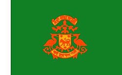
Lunavada State flag.jpg
Flag
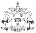
Lunavada State CoA.jpg
Coat of arms
Rewa Kantha Agency with all Princely States Gujarat during British India 1811-1937 with labels.svg
Lunavada State (violet) within Rewa Kantha Agency, British India
Capital Lunavada
Area 
 1901
1,005 km2 (388 sq mi)
Population 
 1901
63,967
History 
 Established
1434
1948
Succeeded by
India Flag of India.svg
Copper coin of Wakhat Singh Lunavada coin of Wakhat Singhu.jpg
Copper coin of Wakhat Singh

Lunavada State, (also spelled as Lunawada State), was a princely state in India during the time of the British Raj. Its last ruler acceded to the Union of India on 10 June 1948.

Contents

Lunavada State had an area of 1,005 km2 [1] and fell under the Rewa Kantha Agency of the Bombay Presidency, later integrated into the Baroda and Gujarat States Agency. Its capital was located in Lunavada town in present-day Gujarat state, India.

During the Rebellion of 1857, The Kolis of Khanpur in Lunawara State revolted against Rana of Lunawada under their Koli chieftain Suralmal of Khanpur. Because of Koli rebellion, Rana sought help from British government and British troops under Major Buckle attacked at Koli rebels and suppressed the rebellions. [2] In 1870, The Kolis again raised and breakdown the peace in the state and British controlled Territories. [3]

History

According to tradition the predecessor state was established in 1225 by descendants of Sidhraj, Raja of Anhilwara Patan, as the state of Virpur. In 1434, Rana Bhimsinghji moved the capital to Lunavada on the other side of the Mahi river. Before the town was established, the area was controlled by the princely Sant State.[ citation needed ]

In 1826 Lunavada State became a British protectorate and was a second class state in the Rewa Kantha Agency. The capital was Lunavada town, said to have been founded in 1434. [4] The 1901 census records that the population had a decrease of 28% in the previous decade, due to famine. [5] [4]

Col. HH Maharaja Sri Virbhadrasinhji Ranjitsinhji 1929/1986, born 8 June 1910 in Lunawada, invested with full ruling powers on 2 October 1930, Member of the Chamber of Princes, married Manher Kunwari [HH Maharani Kusum Kunwari of Lunawada], daughter of Capt. HH Maharana Raj Saheb Shri Sir Amarsinhji Banesinhji (Gangubha) of Wankaner, and had issue. He died in 1986.

Rulers

The rulers had the title 'Rana' and were accorded a status of 9-gun salute by the British authorities. [6]

Ranas

  • 1674–1711: Bir Singh (d. 1711)
  • 1711–1735: Nar Singh (d. 1735)
  • 1735–1757: Wakhat Singh (d. 1757)
  • 1757–1782: Dip Singh (d. 1782)
  • 1782–1786: Durjan Singh (d. 1786)
  • 1786: Jagat Singh
  • 1786–1818: Partab Singh
  • 1818–1849: Fateh Singh (d. 1849)
  • 1849–1851: Dalpat Singh (d. 1851)
  • 1851–1852: interregnum
  • 1852 – June 1867: Dalil Singh (d. 1867)
  • 31 October 1867 – 27 Apr 1929: Wakhat Singh Dalil Singh (b. 1860 – d. 1929) (from 25 May 1889, Sir Wakhat Singh Dalil Singh)
  • 27 Apr 1929 – 15 August 1947 Virbhadra Singh Ranjit Singh (b. 1910 – d. 1986)

See also

Related Research Articles

Kheda is a city and a municipality in the Indian state of Gujarat. It was former administrative capital of Kheda district. India's First Deputy Prime Minister Vallabhbhai Patel Was Born In Kheda District of Gujarat State. Kheda city is famous for tobacco farming. The nearest railway station is Mahemadavad Kheda Road. The nearest airport is Ahmedabad airport. The nearest bus station is Kheda Bus Station.

<span class="mw-page-title-main">Dholpur State</span> Historic Kingdom

Dhaulpur State or Dholpur State, historically known as the Kingdom of Dholpur, was a kingdom of eastern Rajasthan, India, which was founded in AD 1806 by a Jat ruler Rana Kirat Singh of Gohad. After 1818, the state was placed under the authority of British India's Jatwara. The Ranas ruled the state until the independence of India in 1947, when the kingdom was merged with the Union of India.

<span class="mw-page-title-main">Rewa Kantha Agency</span>

Rewa Kantha was a political agency of British India, managing the relations of the British government's Bombay Presidency with a collection of princely states. It stretched for about 150 miles between the plain of Gujarat and the hills of Malwa, from the Tapti River to the Mahi River crossing the Rewa River, from which it takes its name.

Lunavada is a municipality in the Mahisagar district, formerly in the northern part of Gujarat state of India.

<span class="mw-page-title-main">Idar State</span> Former princely state in India

Idar State, also known as Edar, was a princely state located in present-day Gujarat state of India. During the British era, it was a part of the Mahi Kantha Agency, within the Gujarat Division of Bombay Presidency.

The Maliwad Koli, is a Clan (Gotra) of Koli caste found in the Indian state of Gujarat.

<span class="mw-page-title-main">Pateliya</span> Subcaste of Koli caste of Gujarat

The Pateliya, or Patelia or Patel is a landowning Subcaste of Koli caste found in the Indian states of Gujarat. During the British Raj in India, Patelia Kolis served as tax collectors and administrators. The name Patelia comes from a word meaning village chief. Many Patelia Kolis also went into business and commerce during the Raj period. Patelia Kolis are part of Talapada Kolis of Gujarat.

<span class="mw-page-title-main">Baroda State</span> Princely state of India (1721–1949)

Baroda State was a kingdom within the Maratha Confederacy and later a princely state in present-day Gujarat. It was ruled by the Gaekwad dynasty from its formation in 1721 until its accession to the newly formed Dominion of India in 1949. With the city of Baroda (Vadodara) as its capital, its relations with the British Raj authorities were managed by the Baroda Residency. The revenue of the state in 1901 was Rs. 13,661,000. Baroda formally acceded to the Dominion of India on 1 May 1949, before which an interim government was formed in the state.

<span class="mw-page-title-main">Vav, Gujarat</span> Town in Gujarat state, India

Vav is a town and the headquarters of Vav Taluka in Patan district in Gujarat state of India. Vav is the largest taluka of the district.

<span class="mw-page-title-main">Chhota Udaipur State</span> Princely state of India

The Chhota Udaipur State or 'Princely State of Chhota Udaipur', was a princely state with its capital in Chhota Udaipur during the era of British India. The last ruler of Chhota Udaipur State signed the accession to join the Indian Union in 1948. Chhota Udaipur shares a history with Devgadh Baria and Rajpipla as one of the three princely states of eastern Gujarat.

<span class="mw-page-title-main">Sant State</span> Former Hindu Kingdom

The Kingdom of Santrampur or later Sant State was a kingdom and later a princely state in subsidiary alliance with British India. It was ruled by Mahipavat branch of the Paramara dynasty.

<span class="mw-page-title-main">Baroda and Gujarat States Agency</span>

Baroda and Gujarat States Agency was a political agency of British India, managing the relations of the British government of the Bombay Presidency with a collection of princely states.

<span class="mw-page-title-main">Baroda, Western India and Gujarat States Agency</span> Agency of India from 1944 to 1947

The Baroda, Western India and Gujarat States Agency was an agency of the Indian Empire, managing the relations of the Provincial Government of the Bombay Presidency with a collection of princely states.

<span class="mw-page-title-main">Jambughoda State</span>

Jambughoda State, previously known as Narukot and Tokalpur state, was a small princely state in India during the time of the British Raj. Its last ruler acceded to the Union of India on 10 June 1948.

<span class="mw-page-title-main">Baria State</span> Princely state in India

The Baria State, also known as Bariya State, was one of the princely states of India during the period of the British Raj. It was under the Rewa Kantha Agency of the Bombay Presidency and had its capital in Devgadh Baria town of present-day Dahod district in Gujarat state. The Baria State was ruled by Koli chieftains of Baria clan (Gotra) of Gujarat, who later claimed to be kshatriya.

<span class="mw-page-title-main">History of Radhanpur</span>

Radhanpur is a town and a municipality in Patan district in the Indian state of Gujarat. Radhanpur belonged to the Vaghelas in early years and later it was held as a fief under the Gujarat Sultanate by Fateh Khan Baloch. During Mughal period, the descendants of Babi dynasty were appointed as the governor of Radhanpur and other villages of North Gujarat. After decline of Mughal, they became free and established themselves as independent rulers. In 1743, Babi descendant Jawan Mard Khan II took over viceroyalty of Ahmedabad and controlled several villages in North Gujarat. He was defeated by Maratha Gaekwads in 1753 at Ahmedabad and Gaekwads agreed to his demand of control of villages in North Gujarat headquartered at Radhanpur State. His descendants lost some of these villages to Gaekwads subsequently. In 1813, Sher Khan made a treaty with the Gaekwar and British and became British protectorate. His descendants ruled the state until independence of India in 1947.

Diyodar, also spelled Diodar or Deodar, is a town and former princely state in Diyodar Taluka of Banaskantha district in Gujarat, western India.

<span class="mw-page-title-main">Sanjeli</span>

Sanjeli, cotila or sometimes known as Sanjeda Mehvassi, is a Hindu former petty princely state, located in the present Gujarat state in western India.

Angadh was a Mehwal under British India, spanning a part of what is now Vadodara district in Gujarat.

References

  1. Great Britain India Office. The Imperial Gazetteer of India . Oxford: Clarendon Press, 1908
  2. The Hind Rajasthan, Or, The Annals of the Native States of India. New Delhi, India: Usha Publications. 1985. p. 819.
  3. Gujarat (India) (1972). Gujarat State Gazetteers: Panchmahals. New Delhi, India: Directorate of Government Print., Stationery and Publications, Gujarat State. pp. 130: Maliwads.
  4. 1 2 Chisholm, Hugh, ed. (1911). "Lunavada"  . Encyclopædia Britannica . Vol. 17 (11th ed.). Cambridge University Press. p. 123.
  5. "Lunawada Princely State (9 gun salute)". Archived from the original on 2 June 2015. Retrieved 7 July 2014.
  6. Princely States of India

23°08′00″N73°37′00″E / 23.1333°N 73.6167°E / 23.1333; 73.6167