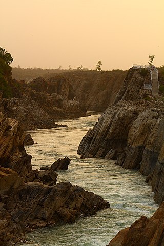
The Narmada River, previously also known as Narbada or anglicised as Nerbudda, is the 5th longest river in India and overall the longest west-flowing river in the country. It is also the largest flowing river in the state of Madhya Pradesh. This river flows through the states of Madhya Pradesh and Gujarat in India. It is also known as the "Lifeline of Madhya Pradesh and Gujarat" due to its huge contribution to the two states in many ways. The Narmada River rises from the Amarkantak Plateau in Anuppur district in Madhya Pradesh. It forms the traditional boundary between North and South India and flows westwards for 1,312 km (815.2 mi) before draining through the Gulf of Khambhat into the Arabian Sea, 30 km (18.6 mi) west of Bharuch city of Gujarat.

The Sardar Sarovar Dam is a concrete gravity dam built on the Narmada River near the town of Kevadiya, in Narmada District, in the Indian state of Gujarat. The dam was constructed to provide water and electricity to the Indian states of Gujarat, Madhya Pradesh, Maharashtra and Rajasthan.

The Tapti River is a river in central India located to the south of the Narmada river that flows westwards before draining into the Arabian Sea. The river has a length of around 724 km and flows through the states of Maharashtra, Gujarat and Madhya Pradesh. It flows through the city of Surat, in Gujarat, and is crossed by the Magdalla, ONGC Bridge.

The Sabarmati River is one of the major west-flowing rivers in India. It originates in the Aravalli Range of the Udaipur District of Rajasthan and meets the Gulf of Khambhat of Arabian Sea after travelling 371 km (231 mi) in a south-westerly direction across Rajasthan and Gujarat. 48 km (30 mi) of the river length is in Rajasthan, while 323 km (201 mi) is in Gujarat.
The Chambal River is a tributary of the Yamuna River in Central and Northern India, and thus forms part of the drainage system of the Ganges. The river flows north-northeast through Madhya Pradesh, running for a brief time through Rajasthan, then forming the boundary between Rajasthan and Madhya Pradesh before turning southeast to join the Yamuna in Uttar Pradesh state.
Banswara is a city in the Banswara district in southern Rajasthan, India. The name, Banswara, came from king ‘Bansiya Bhil’.
Vagad is a region in southeastern Rajasthan state of western India. Its boundaries are roughly defined by those of the districts of Dungarpur and Banswara. Major cities of the region are Dungarpur and Banswara.

The Gandhi Sagar Dam is one of the four major dams built on India's Chambal River. The dam is located in the Mandsaur district of the state of Madhya Pradesh. It is a masonry gravity dam, standing 62.17 metres (204.0 ft) high, with a gross storage capacity of 7.322 billion cubic metres from a catchment area of 22,584 km2 (8,720 sq mi). The dam's foundation stone was laid by Prime Minister of India Pandit Jawaharlal Nehru on 7 March 1954, and construction of the main dam was done by leading contractor Dwarka Das Agrawal & Associates and was completed in 1960. Additional dam structures were completed downstream in the 1970s.
Originating from Pavagadh in the Panchmahal District of Gujarat, the Vishwamitri River flows mainly through the west of the city of Vadodara. The name of this river is said to have been derived from the name of the great saint Vishwamitra. Two other tributaries namely Dhadhar and Khanpur merge into it before it amalgamates with the Gulf of Khambhat. Human settlement dating back to 1000 B.C has been found on the bank of river Vishwamitri which ascertains the existence of Stone Age Era. Also in the beginning of the Christian era, a small township was developed on a mound on the banks of this river which later came to be known as Ankotakka while the mound is popular as Dhantekri. The Vishwamitri River was key to the settlement of Vadodara.
The Indira Sagar Dam is the largest dam in India, in terms of volume of water stored in the reservoir. It is located on the Narmada River at the town of Narmada Nagar, Punasa in the Khandwa district of Madhya Pradesh in India. The foundation stone of the project was laid by the prime minister of India Indira Gandhi on 23 October 1984. The construction of the main dam started in 1992. The downstream projects of ISP are Omkareshwar, Maheshwar, and Sardar Sarovar Project. To build it, a town of 22,000 people and 100 villages was displaced.

The state of Maharashtra in India has several major river systems including those of the Narmada, Tapti, Godavari and Krishna rivers. The ecology of these rivers and associated wetlands is covered in this article.
The Kalpasar Project or the Gulf of Khambhat Development Project envisages building a 30 km dam across the Gulf of Khambat in India for establishing a huge fresh water coastal reservoir for irrigation, drinking and industrial purposes. The project with 30 km sea dam will have the capacity to store 10 billion cubic meters fresh water, equating to 25% of Gujarat’s average annual rainwater flow, from the rivers like Narmada, Mahi, Dhadhar, Sabarmati, Limbdi-Bhagovo, and two other minor rivers. A 10 lane road link will also be set up over the dam, greatly reducing the distance between Saurashtra and South Gujarat. The project, which will create world's largest freshwater lake in marine environment, will cost INR90,000 crore or US$12.75 billion excluding the cost of tidal power plant. Project entails construction of the main "Kalpasar dam" across Gulf of Khambat and another Bhadbhut barrage on Narmada river, as well as a canal connecting the two.
Peepal Khoont mainly known as Pipalkhunt is a village, Tehsil headquarter and Panchayat Samiti of the Pratapgarh district of Rajasthan state. It is a sub-division among the 5 sub-divisions of the Pratapgarh district. The main market is called Sadar Bajar. It is situated on National Highway 113. Pipalkhunt is a town located on the Banswara - Jaipur Expressway surrounded by the hills, plants and trees. The town is situated on the bank of the Mahi River.

Narmada Valley Development Authority (NVDA) concerns Narmada River, the river of Madhya Pradesh. With 87% of its catchment area lying in Madhya Pradesh, it becomes all the more important for the state to exploit this enormous water resource. It was with this motto in mind that the Narmada Valley Development Authority (NVDA) was formed by the government of MP on 9 August 1985. NVDA oversees all major development projects in the Narmada Basin. The body also ensures that proper rehabilitation is provided to the displaced, and the negative impacts on environment are minimized by taking appropriate measures.

The Narmada Canal is a contour canal in Western India that brings water from the Sardar Sarovar Dam to the state of Gujarat and then into Rajasthan state. The main canal has a length of 532 kilometres (331 mi). It is the second longest canal in India and the largest canal by water carrying capacity. The main canal is connected with 42 branch canals providing irrigation to 2,129,000 hectares farmland. The canal is designed to transfer 9.5 million acre-feet water annually from the Narmada Basin to areas under other river basins in Gujarat and Rajasthan..
Kadana Dam is an earthen and masonry on the Mahi River in Mahisagar district of Gujarat, India. The dam was constructed between 1979 and 1990. The dams a pumped-storage hydroelectric power-station. The first two generators were commissioned in 1990, the second two in 1998. The first two generators commissioned, Stage I, are reversible kaplan turbines that allow the power station to generate during peak hours then pump back into the reservoir during low hours such as night.

Mahi Bajaj Sagar Dam is a dam across the Mahi River. It is situated 16 kilometres from Banswara town in Banswara district Rajasthan, India. The dam was constructed between 1972 and 1983 for the purposes of hydroelectric power generation and water supply. It is the longest dam and second largest dam in Rajasthan. It is named after Jamnalal Bajaj. It is the biggest multipurpose project for tribal area of Rajasthan.
The Panam Dam is constructed over the Panam River in India. It is located at Santrampur Taluka of Mahisagar district in Gujarat state. Panam is a tributary of the Mahi River, it originates from Devgadh Baria Taluka of Dahod district. The Panam river merges with the Mahi river 25 kilometres (16 mi) downstream of the Panam Dam.


