The Arabian Sea is a region of sea in the northern Indian Ocean, bounded on the west by the Arabian Peninsula, Gulf of Aden and Guardafui Channel, on the northwest by Gulf of Oman and Iran, on the north by Pakistan, on the east by India, and on the southeast by the Laccadive Sea and the Maldives, on the southwest by Somalia. Its total area is 3,862,000 km2 (1,491,000 sq mi) and its maximum depth is 4,652 meters (15,262 ft). The Gulf of Aden in the west connects the Arabian Sea to the Red Sea through the strait of Bab-el-Mandeb, and the Gulf of Oman is in the northwest, connecting it to the Persian Gulf.
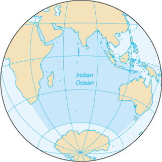
The Indian Ocean is the third-largest of the world's five oceanic divisions, covering 70,560,000 km2 (27,240,000 sq mi) or ~19.8% of the water on Earth's surface. It is bounded by Asia to the north, Africa to the west and Australia to the east. To the south it is bounded by the Southern Ocean or Antarctica depending on the definition in use. Along its core, the Indian Ocean has some large marginal or regional seas such as the Arabian Sea, Laccadive Sea, Bay of Bengal and Andaman Sea.

The Red Sea is a seawater inlet of the Indian Ocean, lying between Africa and Asia. Its connection to the ocean is in the south, through the Bab el Mandeb strait and the Gulf of Aden. To its north lie the Sinai Peninsula, the Gulf of Aqaba, and the Gulf of Suez. It is underlain by the Red Sea Rift, which is part of the Great Rift Valley.

The Arabian Peninsula, or Arabia, is a peninsula in Western Asia, situated northeast of Africa on the Arabian Plate. At 3,237,500 km2 (1,250,000 sq mi), the Arabian Peninsula is the largest peninsula in the world. It is also known as the Arabian subcontinent.

Ingham County is a county located in the U.S. state of Michigan. As of the 2020 Census, the population was 284,900. The county seat is Mason. Lansing, the state capital of Michigan, is largely located within the county. The county is home to Michigan State University, Lansing Community College, and the Class A minor league baseball team Lansing Lugnuts. Ingham County is included in the Lansing–East Lansing, MI Metropolitan Statistical Area. It is considered to be a part of Mid Michigan.

The Hejaz is a region which includes the majority of the west of Saudi Arabia, which includes the cities of Mecca, Medina, Jeddah, Tabuk, Yanbu, Taif and Baljurashi. It is thus known as the "Western Province", and is bordered in the west by the Red Sea, in the north by Jordan, in the east by the Najd, and in the south by the Region of 'Asir. It is the most cosmopolitan region in the Arabian Peninsula. Its largest city is Jeddah, which is the second largest city in Saudi Arabia, with Mecca and Medina respectively being the fourth and fifth largest cities in the country.

The Iranian plateau or Persian plateau is a geological feature in Western Asia, Central Asia, and South Asia. It makes up part of the Eurasian Plate and is wedged between the Arabian Plate and the Indian Plate, situated between the Zagros Mountains to the west, the Caspian Sea and the Köpet Dag to the north, the Armenian Highlands and the Caucasus Mountains to the northwest, the Strait of Hormuz and the Persian Gulf to the south, and the Indian subcontinent to the east.
Mandvi is a Beach town with municipality in the Kutch district in the Indian state of Gujarat. It was once a major port of the region and summer retreat for Maharao (king) of the Cutch State. The old city was enclosed in the fort wall and remains of the fort wall can still be seen. The city has a four-hundred-year-old ship building industry which is still functional and dhows, a type of wooden ship, are still made. Mandvi Municipality's 36 Seat Of 9 Ward.
Babile is one of the districts in the East Hararghe Zone of Oromia Region in Ethiopia. It is named after one of the 12 major clans of the Oromo people, the Babille Oromo. Part of the East Hararghe Zone, Baabile is bordered on the south and east by the Somali Region, on the west by Fedis, and on the north by Gursum; the Fafen River defines a portion of Babille's eastern border. The administrative center of this woreda is Babille Town.
Wadi al-Batin is an intermittent river in Saudi Arabia, Iraq, and Kuwait. It is the lowest and final section of Wadi al-Rummah. It runs 45 mi (72 km) in a northeast–southwest direction through the Al-Dibdibah plain and has been recognized since 1913 as the border between Kuwait and Iraq.
Vajrapu-kotturu is a village in Srikakulam district of the Indian state of Andhra Pradesh. Vajrapukotturu mandal is bordered by Mandasa, Palasa, Nandigam and Santha Bommali mandals of Srikakulam district and has a long coastline off Bay of Bengal. Bendi Gedda river joins the sea after forming a lagoon in this mandal area.
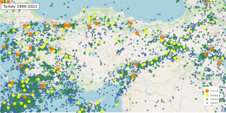
The geology of Turkey is the product of a wide variety of tectonic processes that have shaped Anatolia over millions of years, a process which continues today as evidenced by frequent earthquakes and occasional volcanic eruptions.
Serghaya or Sirghaya is a small town located in the Damascus countryside in south west Syria. According to the Syria Central Bureau of Statistics (CBS), Serghaya had a population of 7,501 in the 2004 census. Its inhabitants are predominantly Sunni Muslims.

Hafar al-Batin, also frequently spelled Hafr al-Batin, is a Saudi Arabian city in the Eastern Province. It is located 430 km north of Riyadh, 94.2 km from the Kuwait border, and about 74.3 from the Iraq border. The city lies in the dry valley of the Wadi al-Batin, which is part of the longer valley of the river Wadi al-Rummah, which leads inland toward Medina and formerly emptied into the Persian Gulf.

The geography of Gujarat state of India includes following:
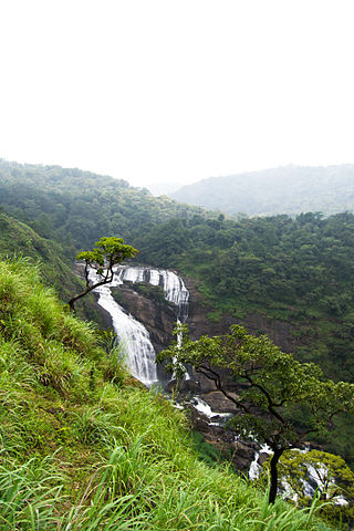
Mallalli Falls is situated in the northern region of Kodagu District, Karnataka. The Kumaradhara River is the main watercourse for this waterfall. The Kumaradhara later flows through Kukke Subrahmanya and merges with the Netravati River at Uppinangadi, which then empties into the Arabian Sea at Mangalore.

Gangavalli River is one of the many small rivers that originates and flows entirely within the western part of state of Karnataka in India. The National Highway 17 (India) continues on the Hosur Bridge the bridge built over Gangavali River and the road continues to split the Ankola and Kumta regions to connect Uttar Kannada district to Dharwar and Mangalore area.

The 2018 North Indian Ocean cyclone season was an above-average period of tropical cyclone formation in the Northern Indian Ocean. The season featured 14 depressions, 10 deep depressions, 7 cyclonic storms, 5 severe cyclonic storms, 4 very severe cyclonic storms, and 1 extremely severe cyclonic storm. The season has no official boundaries, though storms typically form between April and December, with peaks in tropical cyclone activity from May–June and in November.
Chanho is a village in the Chanho CD block in the Ranchi Sadar subdivision of the Ranchi district in the Indian state of Jharkhand.