The Vaal Dam in South Africa was constructed in 1938 and lies 77 km south of OR Tambo International Airport, Johannesburg. The lake behind the dam wall has a surface area of about 320 square kilometres (120 sq mi) and is 47 meters deep. The Vaal Dam lies on the Vaal River, which is one of South Africa's strongest-flowing rivers. Other rivers flowing into the dam are the Wilge River, Klip River, Molspruit and Grootspruit. It has over 800 kilometres (500 mi) of shoreline and is South Africa's second biggest dam by area and the fourth largest by volume.

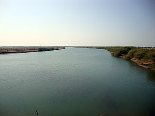
The Daman Ganga also called Dawan River is a river in western India. The river's headwaters are on the western slope of the Western Ghats range, and it flows west into the Arabian Sea. The river flows through Maharashtra and Gujarat states, as well as the Union territory of Dadra and Nagar Haveli and Daman and Diu. The industrial towns of Vapi, Dadra and Silvassa lie on the north bank of the river, and the town of Daman occupies both banks of the river's estuary.

GandhisagarDam is situated at a distance of 168 km from the District headquarter. The Dam is constructed on the Chambal River.

The Wappa Dam is a mass concrete gravity arch dam with earth-fill abutments and an un-gated spillway across the South Maroochy River that is located in the South East region of Queensland, Australia. The main purpose of the dam is for supply of potable water for the Sunshine Coast region. The impounded reservoir is also called Wappa Dam. The dam and most of the reservoir are within Kiamba with the most northerly part of the reservoir in Cooloolabin, both in the Sunshine Coast Region.

The E.J. Beardmore Dam, an earth-fill embankment dam with a concrete gravity wall across the Balonne River, is located in South West Queensland, Australia. The main purpose of the dam is for irrigation. The resultant reservoir is called Lake Kajarabie.
The Koombooloomba Dam is a concrete gravity dam with a controlled spillway across the Tully River, located west of Tully and south, southeast of Ravenshoe in Far North Queensland, Australia. Built for the purpose of hydroelectric power generation, the dam creates the reservoir, Lake Koombooloomba.

The Sterkfontein Dam, located just outside the town of Harrismith, in the Free State, province of South Africa, is part of the Tugela-Vaal Water Project and the Drakensberg Pumped Storage Scheme, and located on the Nuwejaarspruit, a tributary of the Wilge River in the upper catchment area of the Vaal River. It is the second highest dam wall in South Africa and its highest earth fill dam.

The ponmudi dam is a concrete gravity dam built across the Panniyar river which is a tributary of Periyar River at Konnathadi panchayath of Konnathadi village in Idukki district of Kerala, India. The dam was constructed in 1963 as a part of a hydroelectric project. It has a length of 294 metres (965 ft) and a length of 288.80 metres (947.5 ft). The hydropower component of the dam has an installed capacity of 30 MW with firm power of 17 MW, generating 158 GWh annually. Taluks through which the river flow are Udumpanchola, Devikulam, Kothamangalam, Muvattupuzha, Kunnathunadu, Aluva, Kodungalloor and Paravur.

Shihmen Dam is a major rock fill dam across the Dahan River in northern Taoyuan City. It forms the Shihmen Reservoir (石門水庫), Taiwan's third largest reservoir or artificial lake. It provides irrigation in Taoyuan, flood control for the Taipei Basin, and hydroelectricity and domestic water supply for more than three million people in northern Taiwan.
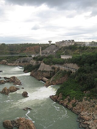
The Paulo Afonso Hydroelectric Complex, also known as the Paulo Afonso Complex, is a system of three dams and five hydroelectric power plants on the São Francisco River near the city of Paulo Afonso in Bahia, Brazil. The complex exploits an 80-metre (260 ft) natural gap on the river, known as the Paulo Afonso Falls. Constructed in succession between 1948 and 1979, the dams support the Paulo Afonso I, II, III, IV and Apollonius Sales (Moxotó) power plants which contain a total of 23 generators with an installed capacity of 4,279.6 megawatts (5,739,000 hp).

The Aras Dam is an embankment dam on the Aras River along the border of Iran and Azerbaijan. It is located downstream of Poldasht in West Azerbaijan Province, Iran and Nakhchivan City in Nakhchivan Autonomous Republic, Azerbaijan. The primary purpose of the dam is hydroelectric power production and water supply.

Zengwen Dam, also spelled Tsengwen Dam, is a major earthen dam in Dapu Township, Chiayi County, Taiwan on the Zengwen River. It is the third tallest dam in Taiwan, and forms Zengwen Reservoir (曾文水庫), the biggest reservoir in Taiwan by volume. The dam stores water for irrigation of the Chianan Plain, Taiwan's most productive agricultural region, and provides flood control along the Zengwen River which flows through Tainan City. The dam supports a 50 megawatt hydroelectric power station.

The Shin-Takasegawa Pumped Storage Station (新高瀬川発電所) uses the Takase River to operate a pumped storage hydroelectric scheme about 12 kilometres (7.5 mi) west of Ōmachi in Nagano Prefecture, Japan. Part of the system is within Chūbu-Sangaku National Park.

The Vianden Pumped Storage Plant is located just north of Vianden in Diekirch District, Luxembourg. The power plant uses the pumped-storage hydroelectric method to generate electricity and serves as a peaking power plant. Its lower reservoir is located on the Our River, bordering Germany, and the upper is elevated above on the nearby Saint Nicholas Mountain. Construction on the plant began in 1959 and the first pump-generators were commissioned in 1962. A tenth pump-generator was installed in 1976 bringing the plant's installed generating capacity to 1,096 megawatts (1,470,000 hp). The plant generates an average of 1,650 gigawatt-hours (5,900 TJ) annually but of course consumes even more. Generally the efficiency of this energy storage method is around 70–80%. The plant is owned by Société électrique de l'Our and RWE. Construction on an eleventh pump-generator began in 2010 and it is expected to be commissioned in 2013, which will bring the plant's installed capacity to 1,296 megawatts (1,738,000 hp).

The Narmada Canal is a contour canal in Western India that brings water from the Sardar Sarovar Dam to the state of Gujarat and then into Rajasthan state. The main canal has a length of 532 kilometres (331 mi). It is the second longest canal in India and the largest canal by water carrying capacity. The main canal is connected with 42 branch canals providing irrigation to 2,129,000 hectares farmland. The canal is designed to transfer 9.5 million acre-feet water annually from the Narmada Basin to areas under other river basins in Gujarat and Rajasthan..
Tumut Two Dam or Tumut Two is a major ungated concrete gravity dam across the upper reaches of the Tumut River in the Snowy Mountains of New South Wales, Australia. The dam's main purpose is for the generation of hydro-power and is one of the sixteen major dams that comprise the Snowy Mountains Scheme, a vast hydroelectricity and irrigation complex constructed in south-east Australia between 1949 and 1974 and now run by Snowy Hydro.

Wingecarribee Dam, completed in 1974 as part of the Shoalhaven Scheme, is an earth and rockfill embankment dam structure located on the Wingecarribee River about 15 kilometres (9.3 mi) southeast of Bowral in New South Wales, Australia. The embankment of 573 cubic metres (20,200 cu ft) is 19 metres (62 ft) high and 1,140 metres (3,740 ft) in length. At 100% capacity, the dam wall holds back approximately 25,875 megalitres and creates the impounded reservoir of Wingecarribee Reservoir that has a surface area of 625 hectares, drawn from a catchment area of 40 square kilometres (15 sq mi). The spillway has a discharge capacity of 520 cubic metres per second (18,000 cu ft/s). Wingecarribee Reservoir lost around 9,000 megalitres of storage capacity as a result of the inflow of peat from the Wingecarribee Swamp collapse in August 1998. The original storage capacity was 34,500 megalitres.

The Vorotan Cascade, or the ContourGlobal™ Hydro Cascade, is a cascade on the Vorotan River in Syunik Province, Armenia. It was built to produce hydroelectric power and provide irrigation water. The Vorotan Cascade consists of three hydroelectric power plants and five reservoirs with a combined installed capacity of 404.2 MW. It is one of the main power generation complexes in Armenia.

The Kanjirapuzha Dam, a masonry earth dam built for providing irrigation to a Cultural Command Area (CCA) of 9,713 hectares, is located in the Palakkad district in the Indian state of Kerala. The reservoir, which has three islands within it, also has an established commercial fisheries development programme operated by the Fisheries Department.

The Castanhão Dam is a dam in the state of Ceará, Brazil. It is the largest multiple use reservoir in the country, the largest on an intermittent river, and the main reservoir for the state and the metropolitan region of Fortaleza. The dam supplies drinking water, and supports industry, irrigation and fish farming. Through steady release of water the dam maintains water flow in the Jaguaribe River throughout the year. During 2012–16 Ceará experienced a prolonged drought. Water levels in the reservoir dropped to 5% of capacity and usage had to be rationed.