Related Research Articles
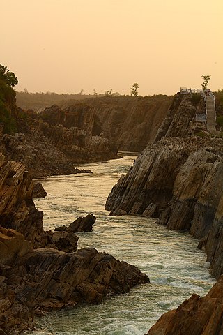
The Narmada River, also called the Reva and previously also known as Narbada or anglicised as Nerbudda, is the 5th longest river and overall longest west-flowing river in India. It is also the largest flowing river in the state of Madhya Pradesh. This river flows through the states of Madhya Pradesh and Gujarat in India. It is also known as the "Life Line of Madhya Pradesh and Gujarat" due to its huge contribution to the two states in many ways. The Narmada River rises from the Amarkantak Plateau in Anuppur district Madhya Pradesh. It forms the traditional boundary between North India and South India and flows westwards over a length of 1,312 km (815.2 mi) before draining through the Gulf of Khambhat into the Arabian Sea, 30 km (18.6 mi) west of Bharuch city of Gujarat.

The Tapti River is a river in central India located to the south of the Narmada river that flows westwards before draining into the Arabian Sea. The river has a length of around 724 km (450 mi) and flows through the states of Maharashtra, Gujarat and Madhya Pradesh. It flows through Surat, and is crossed by the Magdalla, ONGC Bridge.

The Sabarmati river is one of the major west-flowing rivers in India. It originates in the Aravalli Range of the Udaipur District of Rajasthan and meets the Gulf of Khambhat of Arabian Sea after travelling 371 km (231 mi) in a south-westerly direction across Rajasthan and Gujarat. 48 km (30 mi) of the river length is in Rajasthan, while 323 km (201 mi) is in Gujarat.

The Narmada Canal is a contour canal in Western India that brings water from the Sardar Sarovar Dam to the state of Gujarat and then into Rajasthan state. The main canal has a length of 532 kilometres (331 mi). It is the second longest canal in India and the largest canal by water carrying capacity. The main canal is connected with 42 branch canals providing irrigation to 2,129,000 hectares farmland. The canal is designed to transfer 9.5 million acre-feet water annually from the Narmada Basin to areas under other river basins in Gujarat and Rajasthan..
Chok River is a river in western India in Gujarat whose origin is Near Kalarvadh. Its basin has a maximum length of 20 km. The total catchment area of the basin is 63 km2.
Kayla River is a river in western India in Gujarat whose origin is near Sumarasar village. Its basin has a maximum length of 25 km. The total catchment area of the basin is 168 km2.
Keri River is a river in western India in Gujarat whose origin is in the Hindod hills. Its basin has a maximum length of 183 km. The total catchment area of the basin is 560 km2.
Kolak River is a river in Gujarat in western India whose origin is Kaprada taluka. . Its basin has a maximum length of 50 km. The total catchment area of the basin is 584 km2.
Malan River is a river in western India in Gujarat whose origin is Gir forest. Its basin has a maximum length of 55 km. The total catchment area of the basin is 158 km2.

Mindhola River is a river in western India in Gujarat whose origin is near Doswada, Songadh. Its basin has a maximum length of 105 km (65 mi). The total catchment area of the basin is 1,518 km2 (586 sq mi).
Nayra River is a river in western India in Gujarat whose origin is near Mothada. Its basin has a maximum length of 32 km. The total catchment area of the basin is 279 km2.
Rangmati River is a river in western India in Gujarat whose origin is Near Rampar. Its basin has a maximum length of 50 km. The total catchment area of the basin is 518 km2. The city of Jamnagar lies on the banks of this river.
Rav River is a river in western India in Gujarat whose origin is Near Lilpar village. Its drainage basin has a maximum length of 25 km. The total catchment area of the basin is 126 km2.
Rupen River is a river in Gujarat in western India whose origin is the Taranga hills near Kheralu taluka of Mehsana district in Gujarat at an elevation of 180 m above Mean Sea Level and descends in South Western direction. Its drainage basin has a maximum length of 156 km. The total catchment area of the basin is 2,500 square kilometres (970 sq mi).
Rupen River is a river in western India in Gujarat whose origin is Gir Forest. Its basin has a maximum length of 156 km. The total catchment area of the basin is 2500 sq. km.

Saraswati River is a river in western India in Gujarat whose origin is aravali hill. Its basin has a maximum length of 360 km. The total catchment area of the basin is 370 square kilometres (140 sq mi). The Mokeshwar or Mukteshwar dam is on the Saraswati River.
Shahi River is a river in western India in Gujarat whose origin is Near Bhervi village. Its basin has a maximum length of 38 km. The total catchment area of the basin is 163 km2.
Sukhbhadar River is a river in western India in Gujarat whose origin is Vadi hills. Its basin has a maximum length of 194 km. The total catchment area of the basin is 2118 km2.
Utavali River is a river in western India in Gujarat whose origin is Kaniad hills. Its basin has a maximum length of 125 km. The total catchment area of the basin is 388 km2.
Vegdi River is a river in western India in Gujarat whose origin is Near Bhervi village. Its basin has a maximum length of 26 km. The total catchment area of the basin is 119 km2.
References
- ↑ "Bhurud River". guj-nwrws.gujarat.gov.in, Government of Gujarat . Retrieved 13 March 2012.