
Vadodara, also known as Baroda, is the second largest city in the Indian state of Gujarat. It serves as the administrative headquarters of the Vadodara district and is situated on the banks of the Vishwamitri River, 141 kilometres (88 mi) from the state capital of Gandhinagar. The railway line and National Highway 8, which connect Delhi with Mumbai, pass through Vadodara. The city is named for its abundance of the Banyan (Vad) tree. Vadodara is also locally referred to as the Sanskari Nagari and Kala Nagari of India.
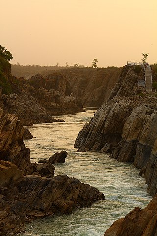
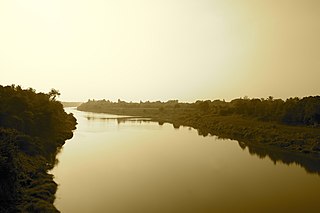
The Narmada River, also called the Reva and previously also known as Narbada or anglicised as Nerbudda, is the 5th longest river and overall longest west-flowing river in India. It is also the largest flowing river in the state of Madhya Pradesh. This river flows through the states of Madhya Pradesh and Gujarat in India. It is also known as the "Life Line of Madhya Pradesh and Gujarat" due to its huge contribution to the two states in many ways. The Narmada River rises from the Amarkantak Plateau in Anuppur district Madhya Pradesh. It forms the traditional boundary between North India and South India and flows westwards over a length of 1,312 km (815.2 mi) before draining through the Gulf of Khambhat into the Arabian Sea, 30 km (18.6 mi) west of Bharuch city of Gujarat.

The Sardar Sarovar Dam is a concrete gravity dam built on the Narmada River in Navagam near the town of Kevadiya, Narmada District, in the state of Gujarat, India. The dam was constructed to provide water and electricity to four Indian states: Gujarat, Madhya Pradesh, Maharashtra, and Rajasthan.

The Mahi is a river in western India. It rises in Madhya Pradesh and, after flowing through the Vagad region of Rajasthan, enters Gujarat and flows into the Arabian Sea. It is one of the relatively few west-flowing rivers in India, alongside the endorheic Luni River, the Sabarmati River, the Tapi River and the Narmada River. Most peninsular rivers in India flow eastward into the Bay of Bengal or northward into the Ganges River.

The Daman Ganga also called Dawan River is a river in western India. The river's headwaters are on the western slope of the Western Ghats range, and it flows west into the Arabian Sea. The river flows through Maharashtra and Gujarat states, as well as the Union territory of Dadra and Nagar Haveli and Daman and Diu. The industrial towns of Vapi, Dadra and Silvassa lie on the north bank of the river, and the town of Daman occupies both banks of the river's estuary.

Sabarmati Riverfront is a waterfront being developed along the banks of Sabarmati river in Ahmedabad, India. Proposed in the 1960s, the construction began in 2005. Since 2012, the waterfront is gradually opened to public as and when facilities are constructed and various facilities are actively under construction. The major objectives of project are environment improvement, social infrastructure and sustainable development.

The Kalpasar Project or the Gulf of Khambhat Development Project envisages building a 30 km dam across the Gulf of Khambat in India for establishing a huge fresh water coastal reservoir for irrigation, drinking and industrial purposes. The project with 30 km sea dam will have the capacity to store 10,000 million cubic meters fresh water, equating to 25% of Gujarat’s average annual rainwater flow, from the rivers like Narmada, Mahi, Dhadhar, Sabarmati, Limbdi-Bhagovo, and two other minor rivers. A 10 lane road link will also be set up over the dam, greatly reducing the distance between Saurashtra and South Gujarat. The project, which will create world's largest freshwater lake in marine environment, will cost INR90,000 crore or US$12.75 billion excluding the cost of tidal power plant. Project entails construction of the main "Kalpasar dam" across Gulf of Khambat and another Bhadbhut barrage on Narmada river, as well as a canal connecting the two.

Dholi Dhaja Dam across the Bhogavo River is located near Surendranagar city and in the urban area of Surendranagar Dudhrej Municipality in the state of Gujarat, India.
Ambika is one of the major rivers in the Indian state of Gujarat. The river has its origins in Saputara Hill ranges in the Nasik district of Maharashtra. Ambika has a drainage area of 2715 km2 and travels 136 km before joining with the Arabian sea. Gira WaterfallArchived 25 December 2015 at the Wayback Machine is on the Ambika River, 2 km from Waghai check post.

The Narmada Canal is a contour canal in Western India that brings water from the Sardar Sarovar Dam to the state of Gujarat and then into Rajasthan state. The main canal has a length of 532 kilometres (331 mi). It is the second longest canal in India and the largest canal by water carrying capacity. The main canal is connected with 42 branch canals providing irrigation to 2,129,000 hectares farmland. The canal is designed to transfer 9.5 million acre-feet water annually from the Narmada Basin to areas under other river basins in Gujarat and Rajasthan..

Machchhu River is a river in Gujarat, India, with its origin in the Madla hills. Its basin has a maximum length of 130 km (81 mi). The total catchment area of the basin is 2,515 km2 (971 sq mi). The river is also occasionally transliterated as Machhu River.

Saraswati River is a river in western India in Gujarat whose origin is aravali hill. Its basin has a maximum length of 360 km. The total catchment area of the basin is 370 square kilometres (140 sq mi). The Mokeshwar or Mukteshwar dam is on the Saraswati River.
The Khodiyar Dam is a dam built on Shetrunji River in Gujarat in western India. The primary purpose of the dam is to provide water for irrigation. It was completed in 1967 and a canal off the reservoir's right bank was completed the next year. The 36.27 m (119 ft) tall earthen dam has a concrete gravity section which serves as the service spillway and an emergency spillway is located on its right bank.

Dharoi Dam is a gravity dam on the Sabarmati river near Dharoi, Satlasana Taluka, Mehsana district of northern Gujarat in India. Constructed in 1978, the dam is meant for irrigation, power generation and flood control.
The Dantiwada Dam is a mud and masonry dam on the West Banas River near Dantiwada, Banaskantha district of northern Gujarat in India. The dam was constructed in 1965 mainly for irrigation and flood control.
Sukhi Dam is an embankment dam on the Sukhi River near the village of Dungarvat in Vadodara district of Gujarat, India. The primary purpose of the dam is the irrigation of a 31,532 ha area with nearly 350 km (220 mi) of canals. It was built between 1978 and 1987. The dam is an earth-fill type with a masonry spillway section.
Bhogavo River is a river in Gujarat, India. It is a major right tributary of the Sabarmati River. The city of Surendranagar is on the banks of the Bhogavo. Dholidhaja Dam is located on the river. The film Guide's climax was shot in the town of Limbdi, 90 km from Ahmedabad on the Bhogavo River. The Harappan port city Lothal is located along Bhogava River.
The Panam Dam is constructed over the Panam River in India. It is located at Santrampur Taluka of Mahisagar district in Gujarat state. Panam is a tributary of the Mahi River, it originates from Devgadh Baria Taluka of Dahod district. The Panam river merges with the Mahi river 25 kilometres (16 mi) downstream of the Panam Dam.
The Bhadbhut barrage or Bhadbhut dam is an under construction barrage on Narmada river near Bhadbhut village in Bharuch district, Gujarat, India. The construction started on 7 August 2020 and will be completed by 2025.
