
The Bhima River is a major river in Western India and South India. It flows southeast for 861 kilometres (535 mi) through Maharashtra, Karnataka, and Telangana states, before joining the Krishna River. After the first sixty-five kilometers in a narrow valley through rugged terrain, the banks open up and form a fertile agricultural area which is densely populated.
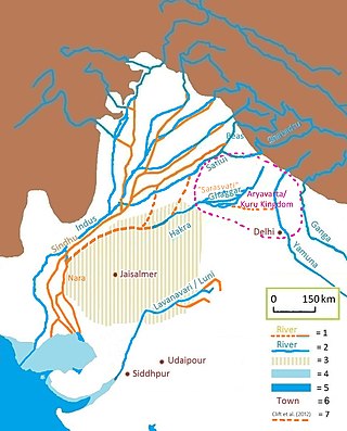
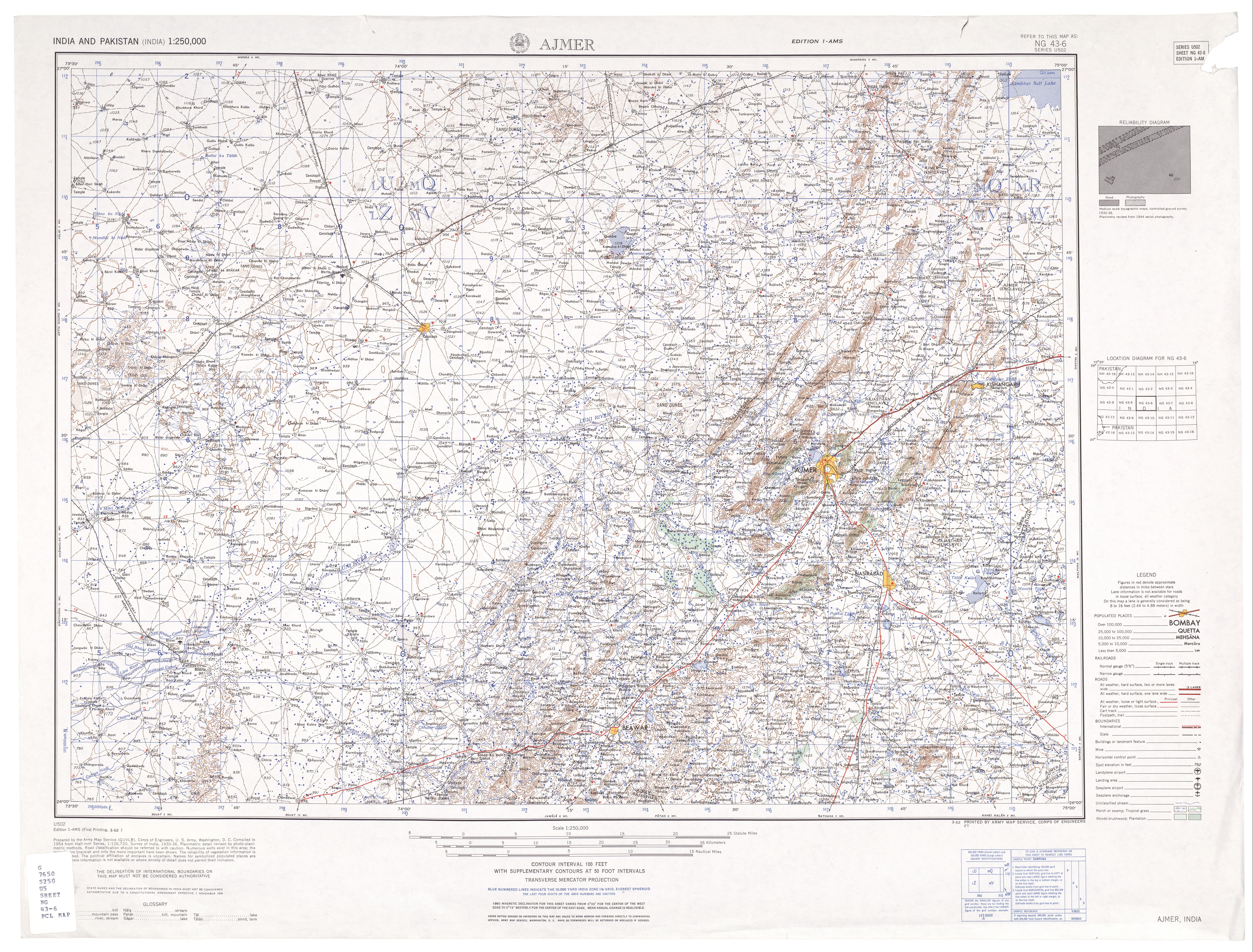
The Luni is the largest river in the Thar Desert of northwest India. It originates in the Pushkar valley of the Aravalli Range, near Ajmer, passes through the southeastern portion of the Thar Desert, and ends in the marshy lands of Rann of Kutch in Gujarat, after travelling a distance of 495 km (308 mi). It is first known as Sagarmati, then after passing Govindgarh, it meets its tributary Sarasvati, which originates from Pushkar Lake and from then on it is called Luni.

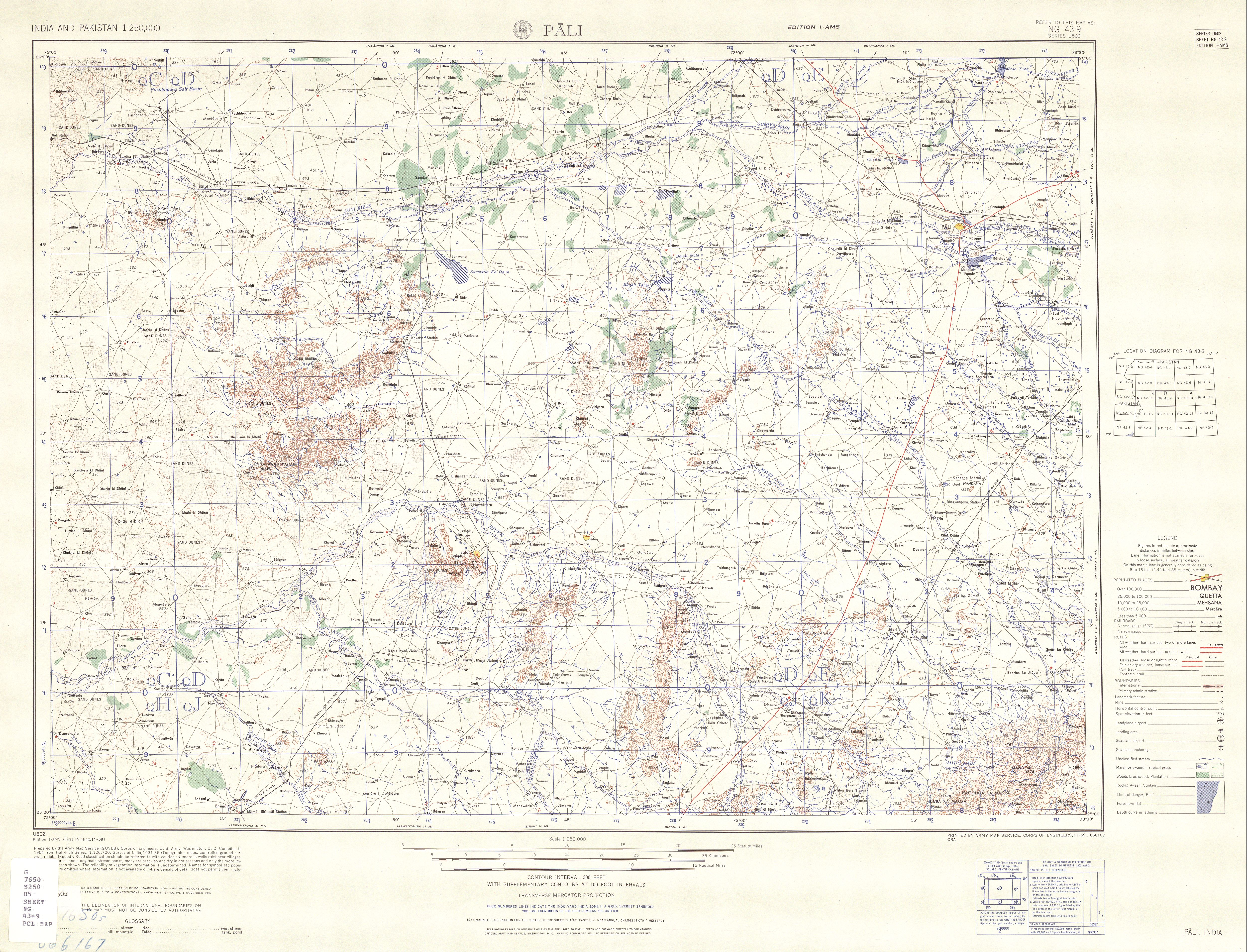
Pali district is a district in Rajasthan, India. The city of Pali is its administrative headquarters. Pali is also known as the Industrial/Textile City and has been a hub for merchant activities for centuries. It has a rich heritage and culture, including beautiful Jain temples and other elaborate monuments.

Jawai Bandh is a dam built across the Jawai River, a tributary of Luni River, in Rajasthan.
Sumerpur is a city in the south part of Pali District of Rajasthan state in India. Named after Maharaja Sumer Singh of Jodhpur, it came into existence in 1912 on the northern bank of Jawai river. The town is headquarters of the Sumerpur revenue subdivision and Sumerpur Tahsil. Sumerpur is an important agricultural mandi for Pali, Sirohi and Jalore districts.
Birami is a panchayat village in Rajasthan, India, on the right (north) bank of the Luni River. Administratively, it is under Luni Taluka, Jodhpur district, Rajasthan.
Mithari is a river in Pali district originates from confluence of many small nallahs from south-western slopes of Aravalli Range in Pali district. It vanishes in Jalore district near Sankhwali village. Bali and Falna comes in its basin. Its catchment area is about 1,644 km2, in Pali and Jalore districts.
The Bandi River, also known as the Hemawas River, is a significant river in the Pali District of Rajasthan, India. It is formed by the confluence of the Khari and Mithari Rivers near the Bombadra pickup weir. The river flows for approximately 45 km before merging with the Luni River near the village of Lakhar.
Jaliwara Khurd or Jaliwada is a village in Rajasthan, India. Administratively, it is under Nanan gram panchayat, Pipar city tehsil, Jodhpur district, Rajastha.
Balesar Durgawatan is a panchayat village in the state of Rajasthan, India, Administratively, Balesar Durgawatan is under Balesar tehsil of Jodhpur District in Rajasthan.
Baori is a panchayat village in the state of Rajasthan, India, Baori is the headquarters town for Bawadi tehsil of Jodhpur District in Rajasthan. Baori is the only village in the gram panchayat.
Malar is a panchayat village in the state of Rajasthan, India. Administratively, it is under Bap tehsil of Jodhpur District of Rajasthan.
Kasti also known as Kaasti is a panchayat village in the state of Rajasthan, India. Administratively, Kasti is under Bawadi tehsil of Jodhpur District in Rajasthan. Kasti is 8 km by gravel road east of the village of Netran (Netra) and National Highway 65. It is 8 km by hard-surfaced road southeast of the town of Baori.
Netra is a panchayat village in the state of Rajasthan, India. Administratively, Netra is under Bawadi tehsil of Jodhpur District in Rajasthan. Netra is the only village in its gram panchayat. The village is located on National Highway 65, 8 km by road southwest of the town of Baori, and 37 km by road north-northeast of the city of Jodhpur.
The Mausam River is a river in Nashik District in Maharashtra, India. It is a left tributary of the Girna River.
Netra is a panchayat village in the state of Rajasthan, India. Administratively, Netra is under Sumerpur Tahsil of Pali District in Rajasthan. The village of Netra is located on National Highway 14, 8 km by road northeast of the town of Sumerpur, and 65 km by road south-southwest of the city of Pali.
Dumara is a panchayat village in Gujarat, India. Administratively it is under Abdasa Taluka, Kutch District, Gujarat. The village of Dumara sits on the left (west) bank of the Chok River, an intermittent stream. It is 20 km (12 mi) by road southeast of the village of Kothara along National Highway 8A, and 38 km (24 mi) along the same road northwest of the town of Mandvi.
The Mitti Dam is a concrete and earthen dam built on the Mitti River in Abdasa Taluka, Kutch District, Gujarat, India. The Mitti River is an intermittent stream and provides a catchment area of 468.78 square kilometres for the reservoir. The dam is located near the village of Trambau and was completed in 1983. The dam is 4405 m long, and has 17.40 million cubic metres (MCM) of gross storage, 2.68 MCM of dead storage, and 14.72 MCM of live storage capacity.
Chorachiwadi is a panchayat village in Maharashtra, India. Administratively, Chorachiwadi is in the Shrigonda taluka of Ahmadnagar District in Maharashtra.
