
The Indus is a transboundary river of Asia and a trans-Himalayan river of South and Central Asia. The 3,120 km (1,940 mi) river rises in mountain springs northeast of Mount Kailash in Western Tibet, flows northwest through the disputed region of Kashmir, bends sharply to the left after the Nanga Parbat massif, and flows south-by-southwest through Pakistan, before emptying into the Arabian Sea near the port city of Karachi.

Ahmedabad is the most populous city in the Indian state of Gujarat. It is the administrative headquarters of the Ahmedabad district and the seat of the Gujarat High Court. Ahmedabad's population of 5,570,585 makes it the fifth-most populous city in India, and the encompassing urban agglomeration population estimated at 6,357,693 is the seventh-most populous in India. Ahmedabad is located near the banks of the Sabarmati River, 25 km (16 mi) from the capital of Gujarat, Gandhinagar, also known as its twin city.

The Sabarmati river is one of the major west-flowing rivers in India. It originates in the Aravalli Range of the Udaipur District of Rajasthan and meets the Gulf of Khambhat of Arabian Sea after travelling 371 km (231 mi) in a south-westerly direction across Rajasthan and Gujarat. 48 km (30 mi) of the river length is in Rajasthan, while 323 km (201 mi) is in Gujarat.

The Daman Ganga also called Dawan River is a river in western India. The river's headwaters are on the western slope of the Western Ghats range, and it flows west into the Arabian Sea. The river flows through Maharashtra and Gujarat states, as well as the Union territory of Dadra and Nagar Haveli and Daman and Diu. The industrial towns of Vapi, Dadra and Silvassa lie on the north bank of the river, and the town of Daman occupies both banks of the river's estuary.

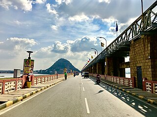
Motera is a neighbourhood in the northwestern part of the metropolis of Ahmedabad in Gujarat, India. It lies west of the Sabarmati River. It falls under the West Zone of Ahmedabad Municipal Corporation and under the Gandhinagar South constituency of Gujarat Legislative Assembly and under the Gandhinagar constituency of the Lok Sabha. The chief attraction in Motera is the world's largest sports stadium, Narendra Modi Stadium. The stadium is the venue for the international cricket matches held in Ahmedabad. In 2015, old stadium was demolished and new stadium was built which got the honour of world's largest stadium.

The Sriram Sagar Project is also known as the Pochampadu Project is an Indian flood-flow project on the Godavari. The Project is located in Nizamabad district, 3 km away from National Highway 44. It has been described by The Hindu as a "lifeline for a large part of Telangana".

The Kosi or Koshi is a transboundary river which flows through China, Nepal and India. It drains the northern slopes of the Himalayas in Tibet and the southern slopes in Nepal. From a major confluence of tributaries north of the Chatra Gorge onwards, the Kosi River is also known as Saptakoshi for its seven upper tributaries. These include the Tamur River originating from the Kanchenjunga area in the east and Arun River and Sun Kosi from Tibet. The Sun Koshi's tributaries from east to west are Dudh Koshi, Likhu Khola, Tamakoshi River, Bhote Koshi, and Indravati. The Saptakoshi crosses into northern Bihar, India where it branches into distributaries before joining the Ganges near Kursela in Katihar district. Kosi is the 3rd largest tributary of the Ganges by water discharge after Ghaghra and Yamuna.
The Indus Water Treaty (IWT) is a water-distribution treaty between India and Pakistan, arranged and negotiated by the World Bank, to use the water available in the Indus River and its tributaries. It was signed in Karachi on 19 September 1960 by then Indian Prime Minister Jawaharlal Nehru and then Pakistani president Ayub Khan.

The Indian Rivers Inter-link is a proposed large-scale civil engineering project that aims to effectively manage water resources in India by linking Indian rivers by a network of reservoirs and canals to enhance irrigation and groundwater recharge, reduce persistent floods in some parts and water shortages in other parts of India. India accounts for 18% of the world population and about 4% of the world’s water resources. One of the solutions to solve the country’s water woes is to link rivers and lakes.

Sabarmati Riverfront is a waterfront being developed along the banks of Sabarmati river in Ahmedabad, India. Proposed in the 1960s, the construction began in 2005. Since 2012, under Phase 1, the waterfront is gradually opened to public as and when facilities are constructed and various facilities are actively under construction. The major objectives of project are environment improvement, social infrastructure and sustainable development. Phase 2 was approved in 2020.

Damodar Valley Corporation (DVC) is a public sector power generator which operates in the Damodar River area of West Bengal and Jharkhand states of India to handle the Damodar Valley Project, the first multipurpose river valley project of independent India. Indian Astrophysicist Meghnad Saha, the former chief architect of river planning in India, prepared the original plan for the Damodar Valley Project. The statutory corporation operates both thermal power stations and hydel power stations under the ownership of Ministry of Power, Government of India. DVC is headquartered in the Kolkata city of West Bengal, India.
The Prakasam Barrage stretches 1223.5 m across the Krishna River connecting Vijayawada, NTR and Mangalagiri Tadepalle Municipal Corporation, Guntur districts in Andhra Pradesh, India. The barrage serves also as a road bridge and spans over a lake. The three canals associated with the barrage run through the city of Vijayawada, crossing it and giving it a Venetian appearance.

The Kalpasar Project or the Gulf of Khambhat Development Project envisages building a 30 km dam across the Gulf of Khambat in India for establishing a huge fresh water coastal reservoir for irrigation, drinking and industrial purposes. The project with 30 km sea dam will have the capacity to store 10 billion cubic meters fresh water, equating to 25% of Gujarat’s average annual rainwater flow, from the rivers like Narmada, Mahi, Dhadhar, Sabarmati, Limbdi-Bhagovo, and two other minor rivers. A 10 lane road link will also be set up over the dam, greatly reducing the distance between Saurashtra and South Gujarat. The project, which will create world's largest freshwater lake in marine environment, will cost INR90,000 crore or US$12.75 billion excluding the cost of tidal power plant. Project entails construction of the main "Kalpasar dam" across Gulf of Khambat and another Bhadbhut barrage on Narmada river, as well as a canal connecting the two.

Durgapur Barrage is built across the Damodar River at Durgapur in Paschim Bardhaman district and partly in Paschim Bardhaman district, in the Indian state of West Bengal. It was constructed by Damodar Valley Corporation mainly for the purpose of irrigation and also to supply water to Industrial township of Durgapur. The irrigation and canal system was transferred to the Government of West Bengal in 1964.

The Pazhassi Dam also called Kulur Barrage is a stone masonry diversion structure in Kannur district, Kerala, India. It is named after king Pazhassi Raja, a patriot who died a heroic death in the war. The dam is constructed across the west flowing Bavali river near Veliyambra. It was commissioned by Prime Minister Morarji Desai in 1979. It mainly functions as an irrigation dam, serving a command area of 11,525 hectares in Iritty taluk of the Kannur District. The water from this dam also meets the drinking water requirement of Kannur district. The dam site and the reservoir are known for their scenery.

Irrigation in India includes a network of major and minor canals from Indian rivers, groundwater well based systems, tanks, and other rainwater harvesting projects for agricultural activities. Of these groundwater system is the largest. In 2013–14, only about 36.7% of total agricultural land in India was reliably irrigated, and remaining 2/3 cultivated land in India is dependent on monsoons. 65% of the irrigation in India is from groundwater. Currently about 51% of the agricultural area cultivating food grains is covered by irrigation. The rest of the area is dependent on rainfall which is most of the times unreliable and unpredictable.

Dharoi Dam is a gravity dam on the Sabarmati river near Dharoi, Satlasana Taluka, Mehsana district of northern Gujarat in India. Completed in 1978, the dam is meant for irrigation, power generation and flood control.

The Hathamati River is a river of western India, in Gujarat, whose origin is in the Aravali Range hills. It is one of the left-bank tributaries of the Sabarmati River. The Hathmati river system includes the Hathamati Dam near Himatnagar. The Guhai River is a tributary of the Hathmati River.
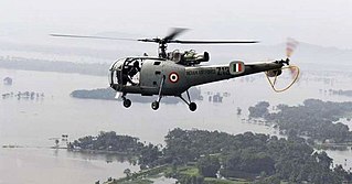
Following heavy rain in July 2017, the Indian state of Gujarat was affected by severe flooding. The floods were reported to have caused total 224 deaths between 1 June and 31 July 2017. 16 people had died in neighbouring Rajasthan state by 31 July.

Meshwo or Meshwa is a river flowing in north and central parts Gujarat, state of India. Meshwo is the tributary river of the Sabarmati and subtribunary of the Vatrak River. It rises in the Panchara hills of Aravalli range, in the Dungarpur district of Rajasthan and enters in Gujarat at Shamlaji.
