
Madhya Pradesh is a state in central India. Its capital is Bhopal, and its largest city is Indore. Other major cities of the state are Jabalpur and Gwalior. Madhya Pradesh is the second largest Indian state by area and the fifth largest state by population with over 72 million residents. It borders the states of Uttar Pradesh to the northeast, Chhattisgarh to the east, Maharashtra to the south, Gujarat to the west, and Rajasthan to the northwest.

Jabalpur, formerly Jubbulpore, is a city situated on the banks of Narmada River in the state of Madhya Pradesh, India. It is the 3rd-largest urban agglomeration of the state and the 38th-largest of the country. Jabalpur is the administrative headquarters of the Jabalpur district and the Jabalpur division. It is the judicial capital of Madhya Pradesh with Madhya Pradesh High Court being located in the city. It is generally accepted that the game of snooker originated in Jabalpur. Jabalpur is also the railway headquarters of the West Central Railway. Jabalpur Cantonment is one of the largest cantonments in India and houses the army headquarters of five states. The city is known for the marble rocks on the river Narmada at Bhedaghat. It is also known as 'Sanskardhani' meaning 'The Cultural Capital' highlighting the city's rich cultural and historical heritage. The city of Jabalpur was among the first 7 smart cities selected for the Smart Cities Mission.

The United Provinces of Agra and Oudh was a province of India under the British Raj, which existed from 22 March 1902 to 1937; the official name was shortened by the Government of India Act 1935 to United Provinces (UP), by which the province had been commonly known, and by which name it was also a province of independent India until 1950.

The Central Provinces and Berar was a province of British India and later the Dominion of India which existed from 1903 to 1950. It was formed by the merger of the Central Provinces with the province of Berar, which was territory leased by the British from the Hyderabad State. Through an agreement signed on 5 November 1902, 6th Nizam Mahbub Ali Khan, Asaf Jah VI leased Berar permanently to the British for an annual payment of 25 lakhs rupees. Lord Curzon decided to merge Berar with the Central Provinces, and this was proclaimed on 17 September 1903.

Sagar, formerly Saugor, is a city, municipal corporation and administrative headquarter in Sagar district of the state of Madhya Pradesh in central India. It's Madhya Pradesh's 6th largest city of by Population. The city is situated on a spur of the Vindhya Range, 1,758 feet (536 m) above sea-level around 172 kilometres (107 mi) northeast of the state capital, Bhopal.

Mandla is a city with municipality in Mandla district in the Indian state of Madhya Pradesh. It is the administrative headquarters of Mandla District. The city is situated in a loop of the Narmada River, which surrounds it on three sides, and for 15 miles between Mandla and Ramnagar, Madhya Pradesh the river flows in a deep bed unbroken by rocks. The Narmada is worshiped here, and many ghats have been constructed on the banks of the river. It was a capital of the Gondwana Kingdom who built a palace and a fort, which in the absence of proper care have gone to ruins.

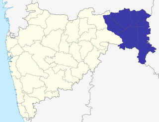
Jabalpur Division is an administrative geographical unit of Madhya Pradesh state of India. Jabalpur is the administrative headquarters of the division. As of 2023, the division consists of districts of Balaghat, Chhindwara, Jabalpur, Katni, Mandla, Narsinghpur, Dindori, Seoni and Pandhurna.

Balaghat district is a district of Madhya Pradesh state in Central India. Its belongs to Jabalpur Division. Balaghat city is Administrative Headquarter of Balaghat District.

Sagar district is a district of Madhya Pradesh state in central India. The town of Sagar serves as its administrative center. Sagar district is called the heart district of India. Tropic of Cancer (23°3') passes through Rangir Tiraha on NH26 present NH44 in Sagar district.
The Nagpur Division is one of six administrative divisions of the state of Maharashtra in India. Nagpur is the easternmost division in the state, with an administrative headquarters in the city of Nagpur. It covers 51,336 km² (19,821 mi²). The Amravati and Nagpur divisions make up the Vidarbha region.
Nagpur Province was a province of British India that covered parts of the present-day states of Madhya Pradesh, Maharashtra, and Chhattisgarh. The city of Nagpur was the capital of the province.
The Central Provinces was a province of British India. It comprised British conquests from the Mughals and Marathas in central India, and covered parts of present-day Madhya Pradesh, Chhattisgarh and Maharashtra states. Nagpur was the primary winter capital while Pachmarhi served as the regular summer retreat. It became the Central Provinces and Berar in 1903.
Chhattisgarh Division was an administrative division of the Central Provinces of British India. It was located in the east of the Central Provinces and encompassed the upper Mahanadi River basin, in the central part of present-day Chhattisgarh state of India.

Ravishankar Shukla was a leader of the Indian National Congress, Indian independence movement activist, the Premier of the Central Provinces and Berar from 27 April 1946 to 25 January 1950, first Chief Minister of the reorganised Madhya Pradesh state from 1 November 1956 until his death on 31 December 1956, he was elected from Saraipali in Madhya Pradesh. He also served as Member of Constituent Assembly of India from Central Provinces and Berar.

The history of Madhya Pradesh can be divided into three periods - the ancient period, the medieval period and modern period.

The history of Nagpur, in central India, spans over 5,000 years, including the Kingdom of Nagpur in the 18th and 19th century. Human existence around present-day Nagpur city can be traced back 3,000 years to the 8th century BC. Menhir burial sites at Drugdhamna indicate megalithic culture existed around Nagpur and is still followed in present times.

Saugor is a railway station in Sagar city in Madhya Pradesh. It is operated by the West Central Railway, with its headquarters at Jabalpur. Saugor is a 'A' Category railway station of West Central Railway zone of Indian Railways. Saugor is a major railway station of Bina–Katni line. The station consists of two platforms. Passenger, Express and Superfast trains halt here.
The Jubbulpore Division, named after its capital Jabalpur (Jubbulpore), was one of the four former administrative divisions of the Central Provinces of British India. It was located in the Mahakoshal region of present-day Madhya Pradesh state of India. The Jubbulpore Division had an area of 48,401 km² with a population of 2,201,633 in 1881.

The Garha kingdom, also called Garha-Mandla or Garha Katanga, was an early-modern-era kingdom in India. It was the first large kingdom to be founded by the Gond tribe kings and was based in Central India. The kingdom was founded in the 15th century and lasted until conquest by the Maratha Confederacy in 1781.
The Saugor subha was a province of the Maratha Empire comprising the central Indian territories of the Peshwa or prime minister. It was ruled by hereditary Maratha Pandit governors who had their headquarters at the city of Sagar.
