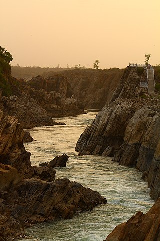
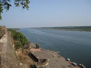
The Narmada River, also called the Reva and previously also known as Narbada or anglicised as Nerbudda, is the 5th longest river and overall longest west-flowing river in India. It is also the largest flowing river in the state of Madhya Pradesh. This river flows through the states of Madhya Pradesh and Gujarat in India. It is also known as the "Life Line of Madhya Pradesh and Gujarat" due to its huge contribution to the two states in many ways. The Narmada River rises from the Amarkantak Plateau in Anuppur district Madhya Pradesh. It forms the traditional boundary between North India and South India and flows westwards over a length of 1,312 km (815.2 mi) before draining through the Gulf of Khambhat into the Arabian Sea, 30 km (18.6 mi) west of Bharuch city of Gujarat.

Pachmarhi is a hill station in Narmadapuram district of Madhya Pradesh state of central India. It has been the location of a cantonment since British Raj.

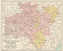
The Central Provinces and Berar was a province of British India and later the Dominion of India which existed from 1903 to 1950. It was formed by the merger of the Central Provinces with the province of Berar, which was territory leased by the British from the Hyderabad State. Through an agreement signed on 5 November 1902, 6th Nizam Mahbub Ali Khan, Asaf Jah VI leased Berar permanently to the British for an annual payment of 25 lakhs rupees. Lord Curzon decided to merge Berar with the Central Provinces, and this was proclaimed on 17 September 1903.
The Satpura Range is a range of hills in central India. The range rises in eastern Gujarat running east through the border of Maharashtra and Madhya Pradesh and ends in Chhattisgarh. The range parallels the Vindhya Range to the north, and these two east-west ranges divide Indian Subcontinent into the Indo-Gangetic plain of northern India and the Deccan Plateau of the south. The Narmada River originates from north-eastern end of Satpura in Amarkantak, and runs in the depression between the Satpura and Vindhya ranges, draining the northern slope of the Satpura range, running west towards the Arabian Sea. The Tapti River originates in the eastern-central part of Satpura, crossing the range in the center and running west at the range's southern slopes before meeting the Arabian Sea at Surat, draining the central and southern slopes of the range. Multai, the place of Tapi river origin is located about 465 kilometer far, south-westerly to Amarkantak, separated across by the hill range. The Godavari River and its tributaries drain the Deccan plateau, which lies south of the range, and the Mahanadi River drains the easternmost portion of the range. The Godavari and Mahanadi rivers flow into the Bay of Bengal. At its eastern end, the Satpura range meets the hills of the Chotanagpur Plateau. The Satpura Range is a horst mountain and is flanked by Narmada Graben in the north and much smaller but parallel Tapi Graben in the south.
Nimar is the southwestern region of Madhya Pradesh state in west-central India. This region has sub-regions which include Nimad, Khandya and Bhuwana.
Barwani or Badwani is a municipal town in Barwani district of Madhya Pradesh, India, that is situated near the left bank of the Narmada River. It is the administrative headquarters of Barwani district and has also served as the capital of the former princely state of Barwani. Barwani is only accessible by road.

Hoshangabad is a city and municipality in the Indian state of Madhya Pradesh. It serves as the headquarters of both Hoshangabad district and Narmadapuram division. It is located in central India, on the south bank of the Narmada River. Hoshangabad is 76.7 km (47.7 mi) from the state capital and the nearest airport Bhopal.

Mahakoshal or Mahakaushal is a region of central India. Mahakoshal lies in the upper or eastern reaches of the Narmada River valley in the Indian state of Madhya Pradesh. Jabalpur is the largest city in the region. Nimar region lies to the west, in the lower reaches of the Narmada valley.

Jabalpur Division is an administrative geographical unit of Madhya Pradesh state of India. Jabalpur is the administrative headquarters of the division. As of 2005, the division consists of districts of Balaghat, Chhindwara, Jabalpur, Katni, Mandla, Narsinghpur, Dindori and Seoni.

Chhindwara district is one of the major districts of Madhya Pradesh state of India, and Chhindwara town is the district headquarters. Chhindwara is the largest district in Madhya Pradesh with an area of 11,815 square km. The district is part of Jabalpur division.

Narsinghpur district is a district of Madhya Pradesh state in central India. The city of Narsinghpur is administrative headquarters of the district. As of 2001 Narsinghpur is the most literate district of MP. Village Singhpur bada in Narsinghpur is also considered as bahubali's and goon's village
Khargone district, formerly known as West Nimar district, is a district of Madhya Pradesh state in central India. The district lies in the Nimar region and is part of the Indore Division. The district headquarters is the city of Khargone, which lies south of the Indore metropolis, the headquarters of Indore district.

Narmadapuram district is one of the districts of Madhya Pradesh state of India, and Narmadapuram city is the district headquarters.

Khandwa district, formerly known as the East Nimar district, is a district of the Madhya Pradesh state in central India. The city of Khandwa is the administrative headquarters of the district. Other notable towns in the district include Mundi, Harsud, Pandhana and Omkareshwar.
The Saugor and Nerbudda Territories, was a region of British India, located in the central part of present-day Madhya Pradesh state in central India. It included the present-day districts of Sagar (Saugor), Damoh, Jabalpur, and Narsinghpur.
The Central Provinces was a province of British India. It comprised British conquests from the Mughals and Marathas in central India, and covered parts of present-day Madhya Pradesh, Chhattisgarh and Maharashtra states. Its capital was Nagpur. Its summer capital was Pachmarhi. It became the Central Provinces and Berar in 1903.
Barwaha is a municipality and tehsil in Khargone district in the state of Madhya Pradesh, India. Barwaha is second biggest city of District after Khargone city. The Barwaha city is divided into 18 wards for which elections are held every 5 years. The Barwaha Municipality has population of 39,973 of which 20,940 are males while 19,033 are females as per report released by Census India 2011. Literacy rate of Barwaha is 87.27% higher than state average of 69.32%. In Barwaha, Male literacy is around 92.73% while female literacy rate is 81.23%.
Kareli is a city and a Municipality in the Indian state of Madhya Pradesh. Kareli is financial capital of the district Narsinghpur. It is well connected by transportation. Near Kareli, an ancient fair called Barman Mela is organised every year in the month of January on the bank of the river Narmada. There are many historic and religious places in Kareli like Deepeshwar Temple Barman, Chougan Fort. India's longest Road NH-44 passes through Kareli and also connected to almost every part of the country by rail network. Before the construction of the Bina-Katni branch of the Indian Midland Railway, the metaled road from Saugor crossing the Nerbudda at Barmhan brought the bulk of the produce of the Sagar District to Kareli station. A mail cart ran from Kareli to Sagar, a distance of 122 km (76 mi). The trade of Kareli has now considerably declined, but it is still the exporting station for the southern parts of the Rehli tahsil of Sagar and the north of Narsinghpur. A cotton-ginning factory, the property of Raja Gokul Das, was opened in 1904. This is the nearest rail station and market for towns of Sagar district.

Indore Junction is one of the Railway junctions in Madhya Pradesh and serves Indore, the commercial capital of Central India. The railway station of Indore Junction BG falls under the administrative control of Western Railway zone of Indian Railways. It consists of six main railway platforms. The Ujjain–Indore route and Indore Junction was electrified in 2011. The Station is located 1 km away from the city centre. It is one of the ISO Certified Railway Stations of India.
Kenud is a village of the Punasa tehsil of Khandwa district, in Madhya Pradesh state, India. The village is almost three hundred years old. Which was founded around 1700 AD by Joraji Singh Badal. Most of the people of the village depend on agriculture, workers and youth are dependent on the nearby city of Mundi and Shree Singaji Thermal Power Project for employment.