Betul district | |
|---|---|
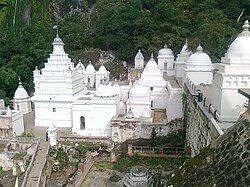  Top: Muktagiri temples Bottom: Kukru Khamla | |
 Location of Betul district in Madhya Pradesh | |
| Coordinates(Betul, Madhya Pradesh): 21°50′N77°50′E / 21.833°N 77.833°E | |
| Country | India |
| State | Madhya Pradesh |
| Division | Narmadapuram |
| Headquarters | Betul |
| Tehsils | |
| Area | |
| • Total | 10,043 km2 (3,878 sq mi) |
| Population (2011) [1] | |
| • Total | 1,575,362 |
| • Density | 160/km2 (410/sq mi) |
| Demographics | |
| • Literacy | 72.1% [2] |
| • Sex ratio | 970 [1] |
| Time zone | UTC+05:30 (IST) |
| Major highways | National Highway 47 |
| Average annual precipitation | 100-125cm mm |
| Website | betul |
Betul district is a district of Madhya Pradesh state in central India. The city of Betul serves as its administrative headquarters. The district is a part of Narmadapuram Division.
Contents
It lies almost wholly on the Satpura range and occupies nearly the whole width of the range between the Narmada Valley on the north and the Berar plains on the south.
History of Betul traces its origin to Satyug according to Skand puran river Tapi in Satyug came to earth for protecting world from excessive heat therefore Tapi is also known as Adi Ganga. Moreover Lord Ram also passed through Betul during his pathway to south, Pandavas passed through Betul during the Agyaat vaas in Vidharbha and built a temple of Shiva in Barahling . Between 161 BC and 130 BC, Betul was the kingdom of the Kundala. From 9th to 12th century, the history of Jains is found in Betul, and its historical evidence can be seen in Muktagiri group of temples. Founder of Sikhism Guru Nanak also visited the holy city and meditated for 15 days in Multai at the origin of holy river Tapi. According to the Persian historian Farishta, there was a Gondwana kingdom, which included Khedla, Devgadh, Gadhmandla, Chandasirpur, etc. during the 13th-14th century. The most popular of the Gond kings was Eel. During 16th and 17th century. Khedla fort of Betul was continuously invaded by the Mughals
In the 18th century, the area of Betul was under the control of Maratha ruler of Berar Raghavji Bhosale, In 1818 AD in Sitavardi, the British Maratha war was fought. In the Treaty, the entire area of Betul was given to the British. During British period, the headquarters of Betul was at Betul Bazar. In 1822, the British shifted the district headquarters to Baddnoor dhana and made Betul the district headquarters. In the older times, Betul was called Badnoor Badd means bad and noor means eye and so Badnoor means evil eye. It is said that in the old times, criminals were kept at this place after mutilation. Hence the name of this place came to be known as Badnoor during the reign of be known as the Gond kings. Initially, Betul was divided into four administrative regions Bhaggudhana, Chunnidhana, Baddnoordhana and Tikari.
Betul is called by the British as the area with a wonderful supernatural environment and Betul's natural beauty and high mountain peaks of Satpura range has mesmerized the crown hence Betul was described as a destination of vacations for British officials. Betul is going to complete the 200 golden years of its establishment in 2022. It was the same year in Shimla the capital of Himachal Pradesh when British officer Ross constructed the first British residence, a mere wood cottage. His successor Lt. Charles Patt Kennedy' erected the first pucca house in 1822 named after Lt. Kennedy as 'Kennedy House' of Shimla . Officer from northern command visited Betul and mentioned Betul and Shimla as the two faces of one coin in his dairy. Since then the unbroken relationship between Shimla and Betul which was established by the British in the pages of history continues till today.
Once a freedom fighter was hanged in Faasi mines and since the area around named as Fassikhadan. The historic Kamani Gate was part of the Victoria Hostel built in the year 1902, where the children of British officers/employees and merchants were sent to stay for education. The Hindi meaning of Betul in cottonless, Cotton was not grown in this region of Berar. For this reason, it was named Betul,
Betul district situated in the heart of India has the distinction of being the place of origin of the holy river Tapti. Situated at the focal point of Akhand Bharat, this district shelters the tribal culture. This tribal-dominated district is situated between the Satpurs hills and Berar plains in the south.