Agar Malwa district

Last updated

Agar Malwa district
Mata Baglamukhi Temple.jpg
Baglamukhi Temple in Nalkheda
MP Agar Malwa district map.svg
Location of Agar-Malwa district in Madhya Pradesh
CountryFlag of India.svg  India
State Madhya Pradesh
Division Ujjain
Headquarters Agar
Tehsils 4
Government
   District Magistrate Awadhesh Sharma IAS
Area
  Total2,785 km2 (1,075 sq mi)
Population
 (2011)
  Total571,278
  Density210/km2 (530/sq mi)
Demographics
   Literacy 51%
Time zone UTC+05:30 (IST)
Vehicle registration MP-70
Website agarmalwa.nic.in

Agar Malwa District is a district in the state of Madhya Pradesh in India. It was carved out of Shajapur district. Its administrative headquarters are situated in the town of Agar.

Contents

History

It was a division during the Sindhia state (some of their palaces are still presently used for city court and for other government offices). It was formerly a cantonment region at the time of India's independence because of the favourable weather and the availability of water. It was a district under the state of Madhya Bharat after the independence of India until 1956. Since 16 August 2013 Agar Malwa has been the 51st district of Madhya Pradesh. The district was formed by removing Agar, Badod, Susner and Nalkheda tehsils from Shajapur District, decreasing its size. [1] It was formerly a cantonment region at the time of India's independence because of the favourable weather and the availability of water. It was a district under the state of Madhya Bharat after the independence of India until 1956. Since 16 August 2013 Agar Malwa has been the 51st district of Madhya Pradesh.

Geography

The western part of the district is marked by the Agar Plateau that covers the major areas of Agar Malwa district. There is a hill tract to the west of the town of Badod, showing scattered hillocks in a north–south direction. The presence of hills in the center has affected the drainage pattern. The height of this tract varies between 500 metres (1,600 ft) and 545 metres (1,788 ft) above the mean sea level and it slopes towards the north.

Dudhaliya and Kachhol are the main streams in the west, originating from the hill tract and draining towards the west. Chhoti Kali Sindh, which is the main perennial stream of the region, flows northwards on the western border of the region.

Demographics

Religions in Agar Malwa district (2011) [2]
ReligionPercent
Hinduism
90.83%
Islam
7.58%
Jainism
1.48%
Other or not stated
0.11%

At the time of the 2011 census, Agar Malwa district had a population of 571,278, of which 117,329 (20.54%) lived in urban areas. Agar Malwa had a sex ratio of 949 females per 1000 males. Scheduled Castes and Scheduled Tribes make up 135,898 (23.79%) and 13,941 (2.44%) of the population respectively. [3]

90.83% of the population were Hindu, 7.58% Muslim, and 1.48% Jain. [2]

Languages of Agar Malwa district (2011) [4]

   Malvi (53.24%)
   Hindi (41.38%)
  Sondwari (4.80%)
  Others (0.58%)

At the time of the 2011 census, 53.24% of the population spoke Malvi, 41.31% Hindi and 4.80% Sondwari as their first language. [4]

Government and politics

Administrative divisions

Agar Malwa District has two sub-divisions, Agar Malwa division and Susner Division. [5] There are four tehsils:

Banking facilities

The list of banks functioning in Agar Malwa:

Places to interest

Related Research Articles

<span class="mw-page-title-main">Rajgarh, Madhya Pradesh</span> City in Madhya Pradesh, India

Rajgarh is a city and a municipality in the state of Madhya Pradesh in India. It is the administrative headquarters of Rajgarh District, and was a princely state under the British Raj, named Rajgarh State. The old city belongs to the Malwa region and is surrounded by a battlemented wall. Rajgarh is now known for NTPC solar power plant and dam projects running over here, as a result companies like Tata and Reliance power have shown interest.Rajgarh is also famous for Jalpama temple

<span class="mw-page-title-main">Shajapur district</span> District of Madhya Pradesh in India

Shajapur District is a district of Madhya Pradesh state of central India. The town of Shajapur is the district headquarters.

Malvi or Malwi is an Indo-Aryan language spoken in the Malwa region of India. It is a dialect of Rajasthani language.

<span class="mw-page-title-main">Kali Sindh River</span> River in India

The Kali Sindh (Krashna Sindhu), is a river in Madhya Pradesh and Rajasthan in northern India. It is a tributary of the Chambal River in the Ganges Basin. The main tributaries of the Kali Sindh are the Parwan, Niwaj and Ahu rivers. The Kali Sindh River drains a major portion of the Malwa region, and is the biggest river flowing in the Malwa region of Madhya Pradesh.

Kanad is a town and a nagar parishad in Agar Malwa district in the Indian state of Madhya Pradesh. It comes under Kanad Parishad. It belongs to Ujjain Division. It is situated along the Agar–Sarangpur SH-41 highway. It is located 18 km (11 mi) towards east from the district headquarters of Agar Malwa, 83 km (52 mi) from Ujjain, 186 km (116 mi) from the state capital of Bhopal.

<span class="mw-page-title-main">Dewas district</span> District of Madhya Pradesh in India

Dewas District is a district in the Indian state of Madhya Pradesh. The town of Dewas is the district headquarters. It belongs to Ujjain Division.

<span class="mw-page-title-main">Ujjain district</span> District of Madhya Pradesh in India

Ujjain district is a district of Madhya Pradesh state in central India. The historic city of Ujjain is the district headquarters. The district has an area of 6,091 km2, and a population of 19,86,864, a 16.12% increase from its 2001 population of 17,10,982.

<span class="mw-page-title-main">Indore district</span> District of Madhya Pradesh, India

The Indore District is a district of Madhya Pradesh state in central India. It is believed that the city is named after its Indreshwar Mahadev Temple, Where Indra is the presiding deity. The Gupta inscriptions name Indore as "Indrapura". It is also called the administrative capital. This district forms part of the Indore Division.

Badod is a city situated in Agar Malwa district in the state of Madhya Pradesh, India. Badod has tehsil headquarters as well as nagar parishad in Agar Malwa District. Both the Choti Kalisindh and Kachal rivers flow nearby the town.

Nalkheda is a town (Tehsil) and a nagar Parishad in Agar Malwa district in the Indian state of Madhya Pradesh. Nalkheda is situated on the bank of river Lakhunder.

Sarangpur is a city and tehsil in Rajgarh district in the Indian state of Madhya Pradesh. It is situated at the bank of the river Kali Sindh.

Soyat Kalan or Soyat is a town and a Nagar Parishad in Agar Malwa district in the Indian state of Madhya Pradesh.

Susner is a town and a Nagar panchayat and Sub division in Agar Malwa district in the Madhya pradesh state of India. Its also a tehsil and a assembly.

Agar is a town with a municipal government in the state of Madhya Pradesh, India. It is the administrative headquarters for the Agar Malwa District which was formed in 2013 from a part of Shajapur District. The town is situated along the Ujjain—Kota SH-27 highway.

Soyat Khurd is a village in the Shajapur district of Madhya Pradesh. Soyat Khurd village with population of 8608 members is located in Agar Malwa district of Madhya Pradesh state. The village is about 26.33 square kilometer in total area. It is located near the town of Soyat Kalan.

Dongargaon, Agar Malwa is a town and a gram panchayat in the Agar Malwa district of Madhya Pradesh. It is located on the Indore–Kota National Highway on the bank of Kali Sindh River.

Dongargaon is the name of several towns or villages within India, and may refer to:

National Highway 552G, commonly referred to as NH 552G is a national highway in India. It is a secondary route of National Highway 52. NH-552G runs in the states of Rajasthan and Madhya Pradesh in India.

<span class="mw-page-title-main">Bagalamukhi Temple, Nalkheda</span> Hindu temple in Madhya Pradesh, India

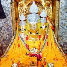
The Bagalamukhi Temple, Nalkheda is located on the banks of the Lakhundar River, a tributary of the Narmada River, in Nalkheda, a town in the Agar Malwa district of Madhya Pradesh, India. It is dedicated to the goddess Bagalamukhi, a devi of the Hindu religion and one of the ten Mahavidyas. She is associated with the colour yellow.

References

  1. "History of Agar Malwa district" . Retrieved 7 October 2019.
  2. 1 2 "Table C-01 Population By Religion: Madhya Pradesh". census.gov.in. Registrar General and Census Commissioner of India.
  3. "District Census Handbook: Shajapur" (PDF). Census of India . Registrar General and Census Commissioner of India. 2011.
  4. 1 2 "Table C-16 Population by Mother Tongue: Madhya Pradesh". censusindia.gov.in. Registrar General and Census Commissioner of India.
  5. "Agar-Malwa becomes MP's 51st district". 14 August 2013. Archived from the original on 6 November 2013.
  6. "Collectorate".
  7. "Canara Bank Limited Agar Malwa Branch".
  8. "Au Small Finance Bank Limited Agar Malwa Branch".
  9. "Bank Of Baroda, Agar Malwa, Branch".
  10. "Bank Of India Agar Malwa Branch".
  11. "Bank Of India Collectorate, Agar Malwa Branch".
  12. "DCB Bank Limited Pal Branch".
  13. "IDFC First Bank Ltd Agar Malwa Branch".
  14. "Indian Bank Agar Malwa Branch".
  15. "Indian Bank Dongargaon Branch".
  16. "UNION BANK OF INDIA Agar Malwa Branch".
  17. 1 2 3 4 5 6 7 8 9 "पर्यटक स्थल". जिला आगर मालवा, मध्य प्रदेश शासन - भारत (in Hindi). Retrieved 2 August 2024.

23°42′54″N76°00′47″E / 23.715°N 76.013°E / 23.715; 76.013