Khargone district

Last updated

Khargone district
Maheshwar fort as seen from the Narmada river.jpg
0102221 Mahakaleswar temple 1, Un, Khargone district, Madhya Pradesh 009.jpg
Nagarpalika.jpg
Gogawan, Madhya Pradesh 451335, India - panoramio.jpg
Clockwise from top-left: Maheshwar Fort from Narmada,, Nagar Palika building of Sanawad, hills near Gogawan, Mahalakeshwar Temple, Un
MP Khargone district map.svg
Location of Khargone district in Madhya Pradesh
CountryFlag of India.svg  India
State Madhya Pradesh
Division Indore
Headquarters Khargone
Government
   Lok Sabha constituencies Khargone (Lok Sabha constituency)
Area
  Total8,030 km2 (3,100 sq mi)
Population
 (2011)
  Total1,873,046
  Density230/km2 (600/sq mi)
Demographics
   Literacy 63.98%
  Sex ratio965
Time zone UTC+05:30 (IST)
Major highways Chittaurgarh - Bhusawal Highway, Khandwa - Vadodara Highway, Agra-Mumbai Highway, Indore-Icchapur Highway, Madhya Pradesh
Website khargone.nic.in

Khargone district, formerly known as West Nimar district, is a district of Madhya Pradesh state in central India. The district lies in the Nimar region and is part of the Indore Division. The district headquarters is the city of Khargone, which lies south of the Indore metropolis, the headquarters of Indore district.

Contents

History

In ancient times, the Haihayas of Mahishmati (present-day Maheshwar) ruled the region. In the early medieval ages, the area was under the Paramaras of Malwa and the Ahirs of Asirgarh. In the late medieval ages, the area was under the Malwa Sultanate of Mandu.

In 1531, Gujarat sultan Bahadur Shah brought this area under his control. In 1562, Akbar annexed this territory along with the whole Malwa to Mughal empire. In 1740, Marathas under the Peshwa brought the area under their control. In 1778, the Peshwa distributed this territory to the Maratha rulers: Holkars of Indore, Shinde (Scindia)11 of Gwalior, and Ponwars of Dhar.

After the independence and merging of the Princely states into the Union of India in 1948, this territory became West Nimar district of Madhya Bharat. Khargone district had been part of the Nerbudda (Narmada) Division of the Central Provinces and Berar, which became the state of Madhya Bharat (later Madhya Pradesh) after India's independence in 1947. [1] On 1 November 1956, this district became part of the newly formed state of Madhya Pradesh. On 25 May 1998, West Nimar district was bifurcated into two districts: Khargone and Barwani.

Geography

The area of the Khargone district is 8,030 km2 (3,100 sq mi). The district is situated between 21°22' and 22°35' north latitudes and 74°25' and 76°14' east longitudes. The district is surrounded by the districts of Dhar, Indore, and Dewas to the north; Jalgaon district of Maharashtra state to the south; Khandwa and Burhanpur districts to the east; and Barwani district to the west.

Economy

Khargone's economy is dependent on agriculture, with several other industries in the cities of Nimrani and Barwaha. The major cash crops of the Khargone district are cotton, soybean, and chilli pepper.

The district is India's biggest cotton-producing region. There are various cotton processing units (spinning) in the cooperative sector and private sector. One of the major spinning units is the cooperative Jawaharlal Nehru Sahakari Soot Mill, situated on Julwania Road.[ citation needed ] The famous Sendhwa cotton hub is just 70 km from Khargone city.

The red chilli pepper is exported abroad. A famous mandi[ clarification needed ] of chilli at Bedia is located about 50 km from Khargone city.

Divisions

The district is divided into two sub-divisions, Barwaha and Khargone, which are further divided into 9 tehsils. The Barwaha sub-division has 3 big tehsils (Barwaha, Maheshwar, and Kasrawad) which cover 50% of the area of the Khargone district, while the Khargone sub-division has 6 small tehsils (Khargone, Gogawan, Segaon, Bhagwanpura, Bhikangaon, and Jhirnya) which cover the remaining 50% of the area. [2]

Khargone city is the administrative headquarters of the district. Other towns include Maheshwar, Kasrawad, Segaon, Bhagwanpura, Jhirnya, Bhikangaon, Gogawan, and Barwaha. Maheshwar is a tourist destination due to it being the former capital of the Haihayas and the Holkars of Indore.

The district consists of six Vidhan Sabha constituencies: Bhikangaon, Barwaha, Maheshwar, Kasrawad, Khargone, and Bhagwanpura. Bhikangaon and Barwaha are a part of the Khandwa Lok Sabha constituency, while the rest are part of the Khargone Lok Sabha constituency.

Demographics

Religions in Khargone district (2011) [4]
ReligionPercent
Hinduism
92.12%
Islam
7.21%
Other or not stated
0.67%

According to the 2011 census, Khargone district has a population of 1,873,046, [5] roughly equal to the population of Kosovo [6] or the US state of West Virginia. [7] It ranks 252nd out of the 640 districts in India in terms of population. [5] The district has a population density of 233 inhabitants per square kilometre (600/sq mi). [5] Its population growth rate over the decade 2001–2011 was 22.81%. [5] West Nimar has a sex ratio of 963 females for every 1000 males, [5] and a literacy rate of 63.98%. 15.96% of the population lives in urban areas. Scheduled Castes and Scheduled Tribes make up 11.16% and 38.98% of the population, respectively. [5]

Languages

Languages of Khargone district (2011) [8]

   Nimadi (51.80%)
   Hindi (17.38%)
   Bareli (11.10%)
   Bhilali (6.74%)
   Bhili (6.43%)
   Urdu (1.98%)
   Banjari (1.81%)
  Others (2.76%)

At the time of the 2011 census, 51.80% of the population in the district spoke Nimadi, 17.38% Hindi, 11.10% Bareli, 6.74% Bhilali, 6.43% Bhili, 1.98% Urdu, 1.81% Banjari, 0.61% Gujarati, and 0.43% Marathi as their first language. [8]

Nimadi is the most spoken language in west Nimar. Bareli Palya, a Bhil language, has approximately 10,000 speakers, centered in Madhya Pradesh; [9] Bareli Rathwi, another Bhil language, has approximately 64,000 speakers, written in the Devanagari script; [10] and Bhilali has 1,150,000 speakers. [11]

Villages

Related Research Articles

<span class="mw-page-title-main">Malwa</span> Place in India

Malwa is a historical region of west-central India occupying a plateau of volcanic origin. Geologically, the Malwa Plateau generally refers to the volcanic upland north of the Vindhya Range. Politically and administratively, it is also synonymous with the former state of Madhya Bharat which was later merged with Madhya Pradesh. At present the historical Malwa region includes districts of western Madhya Pradesh and parts of south-eastern Rajasthan. Sometimes the definition of Malwa is extended to include the Nimar region south of the Vindhyas.

Nimar is the southwestern region of Madhya Pradesh state in west-central India. This region has sub-regions which include Nimad, Khandwa and Harda.

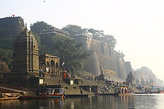
Barwani or Badwani is a municipal town in Barwani district of Madhya Pradesh, India, that is situated near the left bank of the Narmada River. It is the administrative headquarters of Barwani district and has also served as the capital of the former princely state of Barwani. Barwani is only accessible by road.

<span class="mw-page-title-main">Maheshwar</span> Town in Madhya Pradesh, India

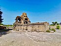
Maheshwar is a town, near Khargone city in Khargone district of Madhya Pradesh state, in central India. It is located on State Highway-38 ,13.5 km east of National Highway 3 and 91 km from Indore, the commercial capital of the state. The Town lies on the north bank of the Narmada River. It was the kingdom of Chaktavartin Samrat Sahastraarjun, Kartavirya Arjuna a Heheya king. Lately, after many years, it was the capital of the Malwa during the Maratha Holkar reign till 6 January 1818, when the capital was shifted to Indore by Malhar Rao Holkar III.

<span class="mw-page-title-main">Bhil languages</span> Indo-Aryan language group of India

The Bhil languages are a group of Indo-Aryan languages spoken by around 10.4 million Bhils in western and central India as of 2011. They constitute the primary languages of the southern Aravalli Range in Rajasthan and the western Satpura Range in Madhya Pradesh, northwestern Maharashtra, and southern Gujarat. According to the 52nd report of the commissioner for linguistic minorities in India, Ministry of Minority Affairs, Bhili is the most commonly spoken language of the district of Dadra and Nagar Haveli constituting 40.42% of its total population. Bhili speakers are also significant in the states of Gujarat (4.75%), Madhya Pradesh (4.93%) and Rajasthan (4.60%).

Mandleshwar is a town and nagar panchayat in the Khargone district of the India state of Madhya Pradesh. It is on the banks of Narmada River, 8 kilometres (5.0 mi) east of Maheshwar and 99 kilometres (62 mi) south of Indore. It is a "Pavitra nagri" as termed by the government of Madhya Pradesh, as it is an ancient town. It is the education centre of Maheshwar block, the location of the district court and district jail of Khargone, and is also the political centre of Maheshwar block.

<span class="mw-page-title-main">Dewas district</span> District of Madhya Pradesh in India

Dewas District is a district in the Indian state of Madhya Pradesh. The town of Dewas is the district headquarters.

<span class="mw-page-title-main">Jhabua district</span> District of Madhya Pradesh in India

Jhabua is a district of Madhya Pradesh state in central India. The town of Jhabua is the administrative headquarters of the district.

<span class="mw-page-title-main">Barwani district</span> District of Madhya Pradesh in India

Barwani district is one of the districts of Madhya Pradesh state of India. The administrative headquarters of the district is at Barwani. Barwani district has an area of 5,427 km² and a population 1,385,881. The district lies in the southwestern corner of Madhya Pradesh; the Narmada River forms its northern boundary. The Satpura Range lies to its south. The district is bordered by Maharashtra state to the south, Gujarat state to the west, Dhar District to the north and Khargone District to the east.

<span class="mw-page-title-main">Burhanpur district</span> District of Madhya Pradesh in India

Burhanpur District is a district of Madhya Pradesh state in central India. The city of Burhanpur is the district headquarters.

<span class="mw-page-title-main">Dhar district, India</span> District of Madhya Pradesh in India

Dhar district is a district of Madhya Pradesh state in central India. The historic town of Dhar is administrative headquarters of the district.

<span class="mw-page-title-main">Indore district</span> District of Madhya Pradesh, India

The Indore District is a district of Madhya Pradesh state in central India. It is believed that the city is named after its Indreshwar Mahadev Temple, Where Indra is the presiding deity. The Gupta inscriptions name Indore as "Indrapura". It is also called the administrative capital. This district forms part of the Indore Division.

<span class="mw-page-title-main">Khandwa district</span> District of Madhya Pradesh in India

Khandwa district, formerly known as the East Nimar district, is a district of the Madhya Pradesh state in central India. The city of Khandwa is the administrative headquarters of the district. Other notable towns in the district include Mundi, Harsud, Pandhana and Omkareshwar.

<span class="mw-page-title-main">Khargone</span> City in Madhya Pradesh, India

Khargone is a city and administrative headquarters of an Khargone district in the Indian state of Madhya Pradesh. The city is located on the bank of the Kunda river and is known for its cotton and chilly production. It is also known for Navgraha Mandir, a temple devoted to the nav grahas. Khargone topped the nation in municipality and received a national award for 'India's Fastest Moving City' under a population of two lakh. Khargone ranked 10th Cleanest city in India in Swachh Survekshan 2020 City ranked the 15th cleanest city in India in Swachh Survekshan 2018 and ranked 17th cleanest city in India in Swachh Survekshan 2017.

Barwaha is a municipality and sub district in Khargone district in the state of Madhya Pradesh, India situated on the banks of Narmada river. Barwaha is second biggest city of District after Khargone city. The Barwaha city is divided into 28 wards for which elections are held every 5 years. The Barwaha Municipality has population of 61,973 of which 32,940 are males while 29,033 are females as per report released by Census India 2011. Literacy rate of Barwaha is 87.27% higher than state average of 69.32%. In Barwaha, Male literacy is around 92.73% while female literacy rate is 81.23%.

Kasrawad is a tehsil and nagar panchayat in Khargone district in the Indian state of Madhya Pradesh.

Sanawad is an Indian town in Khargone district in the Indian state of Madhya Pradesh. It is a popular center for the trade of cotton and wheat. Nearby cities include Khargone, Khandwa, Barwaha and Indore.

Nimadi is a Western Indo-Aryan language spoken in the Nimar region of west-central India within the state of Madhya Pradesh. This region lies adjacent to Maharashtra and south of Malwa. The districts where Nimadi is spoken are: Barwani, Khandwa, Barwaha, Khargone, Burhanpur, Bedia, Sanawad and parts of Dhar, Harda and South Dewas districts. The famous writers of Nimari were Gaurishankar Sharma, Ramnarayan Upadhyay, surendra khede etc.

Mardana is a village in the state of Madhya Pradesh located on the banks of the river Narmada in India. The village falls under the Nimar region. The region predominantly speaks the local dialect "Nimadi" and Hindi. Nearest airport is Indore and nearest railway station is Khandwa.

<span class="mw-page-title-main">Bakawan</span> Village in Madhya Pradesh, India

Bakawan is a village in the state of Madhya Pradesh located on the banks of the river Narmada in India. The village falls under the Nimar region in Malwa. The region predominantly speaks the local dialect "Nimadi" and Hindi. Nearest airport is Indore and nearest railway station is Khandwa.

References

  1. Hunter, William Wilson, Sir, et al. (1908). Imperial Gazetteer of India, Volume 6. 1908-1931; Clarendon Press, Oxford
  2. "Man helps cops arrest rape accused, gets beaten up in Chenpur jail". Hindustan Times. HT Media Limited. 26 July 2014. Archived from the original on 2 April 2015. Retrieved 26 March 2015.
  3. "Table A-02 Decadal Variation in Population Since 1901: Madhya Pradesh" (PDF). census.gov.in. Registrar General and Census Commissioner of India.
  4. "Table C-01 Population By Religion: Madhya Pradesh". census.gov.in. Registrar General and Census Commissioner of India.
  5. 1 2 3 4 5 6 "District Census Handbook: Khargone" (PDF). Census of India . Registrar General and Census Commissioner of India. 2011.
  6. US Directorate of Intelligence. "Country Comparison:Population". Archived from the original on 13 June 2007. Retrieved 1 October 2011. Kosovo 1,825,632 July 2011 est.
  7. "2010 Resident Population Data". U. S. Census Bureau. Archived from the original on 19 October 2013. Retrieved 30 September 2011. West Virginia 1,852,994
  8. 1 2 "Table C-16 Population by Mother Tongue: Madhya Pradesh". censusindia.gov.in. Registrar General and Census Commissioner of India.
  9. M. Paul Lewis, ed. (2009). "Bareli, Palya: A language of India". Ethnologue: Languages of the World (16th ed.). Dallas, Texas: SIL International. Retrieved 28 September 2011.
  10. M. Paul Lewis, ed. (2009). "Bareli, Rathwi: A language of India". Ethnologue: Languages of the World (16th ed.). Dallas, Texas: SIL International. Retrieved 28 September 2011.
  11. M. Paul Lewis, ed. (2009). "Bhilali: A language of India". Ethnologue: Languages of the World (16th ed.). Dallas, Texas: SIL International. Retrieved 30 September 2011.

21°49′23″N75°36′37″E / 21.82306°N 75.61028°E / 21.82306; 75.61028