Jabalpur district

Last updated

Jabalpur district
Rani Durgavati Fort.jpg
0010322 Chausath Yogini Temple and Gowri Shankar Temple, Bhedaghat Madhya Pradesh 054.jpg
Bhedaghat Water Fall.jpg
Path of the cycling track at the Dumna Nature Reserve.jpg
Sunrise gwarighat.jpg
Clockwise from top-left: Madan Mahal in Jabalpur, Chausath Yogini Temple, Bhedaghat, Dumna Nature Reserve Park, sunrise at Gwarighat, Dhuandhar Falls
MP Jabalpur district map.svg
Location of Jabalpur district in Madhya Pradesh
CountryFlag of India.svg  India
State Madhya Pradesh
Division Jabalpur
Headquarters Jabalpur
Government
   Lok Sabha constituencies Jabalpur
Area
  Total5,198 km2 (2,007 sq mi)
Population
 (2011)
  Total2,463,289
  Density470/km2 (1,200/sq mi)
Demographics
   Literacy 82.47%
  Sex ratio925 females/1000 males
Time zone UTC+05:30 (IST)
Website jabalpur.nic.in

Jabalpur district is a district of Madhya Pradesh state in central India. The city of Jabalpur is the administrative headquarters of the district.

Contents

The area of the district is 5,198 km2 [1] with population of 2,463,289 (2011 census). As of 2011 it is the second most populous district of Madhya Pradesh (out of 50), after Indore. [2]

Jabalpur district is located in the Mahakoshal region of Madhya Pradesh, on the divide between the watersheds of Narmada and the Son, but mostly within the valley of the Narmada, which here runs through the famous gorge known as the Marble rocks, and falls 30 ft. over a rocky ledge (the Dhuan Dhar, or misty shoot ). It consists of a long narrow plain running north-east and south-west and shut in on all sides by highlands. This plain, which forms an offshoot from the great valley of the Narmada, is covered in its western and southern portions by a rich alluvial deposit of black cotton soil. At Jabalpur city, the soil is black cotton soil, and water plentiful near the surface. The north and east belong to the basin of the Son River, a tributary of the Ganges and Yamuna, the south and west to the Narmada basin. The district is traversed by the main railway from Mumbai to Kolkata, and by branches of two other lines which meet at Katni junction. [3]

Geography

The district is part of Jabalpur Division. It has an average elevation of 411 metres (1348 ft).

Sub Divisions

  1. Jabalpur
  2. Panagar
  3. Shahpura
  4. Patan
  5. Kundam
  6. Majholi
  7. Sihora

Climate

Climate data for Jabalpur Airport (1981–2010, extremes 1901–2011)
MonthJanFebMarAprMayJunJulAugSepOctNovDecYear
Record high °C (°F)33.4
(92.1)
37.6
(99.7)
41.1
(106.0)
45.4
(113.7)
46.7
(116.1)
46.1
(115.0)
41.7
(107.1)
38.4
(101.1)
35.8
(96.4)
37.9
(100.2)
35.8
(96.4)
33.2
(91.8)
46.7
(116.1)
Mean daily maximum °C (°F)24.6
(76.3)
27.8
(82.0)
33.4
(92.1)
38.5
(101.3)
41.1
(106.0)
37.7
(99.9)
31.3
(88.3)
29.8
(85.6)
31.1
(88.0)
31.7
(89.1)
28.9
(84.0)
25.7
(78.3)
31.8
(89.2)
Mean daily minimum °C (°F)10.6
(51.1)
13.2
(55.8)
17.8
(64.0)
22.9
(73.2)
27.1
(80.8)
26.8
(80.2)
24.6
(76.3)
24.0
(75.2)
23.5
(74.3)
20.0
(68.0)
14.5
(58.1)
10.8
(51.4)
19.6
(67.3)
Record low °C (°F)1.1
(34.0)
0.0
(32.0)
3.3
(37.9)
10.6
(51.1)
17.2
(63.0)
19.0
(66.2)
20.6
(69.1)
18.3
(64.9)
16.7
(62.1)
6.8
(44.2)
3.9
(39.0)
0.6
(33.1)
0.0
(32.0)
Average rainfall mm (inches)21.9
(0.86)
24.6
(0.97)
14.9
(0.59)
4.8
(0.19)
11.4
(0.45)
168.0
(6.61)
376.6
(14.83)
401.9
(15.82)
220.9
(8.70)
30.2
(1.19)
10.1
(0.40)
6.0
(0.24)
1,291.4
(50.84)
Average rainy days1.81.61.20.51.27.414.314.99.02.00.70.655.2
Average relative humidity (%) (at 17:30 IST)49372519214773797053515148
Source: India Meteorological Department [4] [5]

Demographics

Historical population
YearPop.±% p.a.
1901430,810    
1911472,102+0.92%
1921471,951−0.00%
1931489,583+0.37%
1941576,167+1.64%
1951662,569+1.41%
1961821,579+2.17%
19711,119,885+3.15%
19811,484,235+2.86%
19911,768,037+1.77%
20012,151,203+1.98%
20112,463,289+1.36%
source: [6]

According to the 2011 census Jabalpur district has a population of 2,463,289 [2] roughly equal to the nation of Kuwait [7] or the US state of Nevada. [8] This gives it a ranking of 180th in India (out of a total of 640). [2] The district has a population density of 472 inhabitants per square kilometre (1,220/sq mi). [2] Its population growth rate over the decade 2001-2011 was 14.39%. [2] Jabalpur has a sex ratio of 925 females for every 1000 males, [2] and a literacy rate of 82.47%. 58.46% of the population lives in urban areas. Scheduled Castes and Tribes made up 14.13% and 15.23% of the population respectively. [2]

Religions in Jabalpur district (2011) [9]
ReligionPercent
Hinduism
87.65%
Islam
8.27%
Jainism
1.37%
Christianity
0.94%
Other religions (tribal)
0.85%
Sikhism
0.54%
Other or not stated
0.38%

Hindus are majority religion in Jabalpur district with 87.65%, Muslims with 8.27% and rest of Jains, Sikhs and Christians. [9]

Languages

Languages of Jabalpur district (2011) [10]

   Hindi (94.21%)
   Urdu (1.93%)
  Others (3.86%)

At the time of the 2011 Census of India, 94.21% of the population in the district spoke Hindi and 1.93% Urdu as their first language. [10]

The dialect of the region is Baghelkhandi. Other languages spoken in the district by a significant number of people in the district include Marathi, Punjabi, Sindhi and Bengali, almost exclusively in Jabalpur city.

Education

Jabalpur is an important educational centre of the Madhya Pradesh state. Jabalpur has Rani Durgavati University, Jawahar Lal Nehru Krishi University, Madhya Pradesh Pashu Chikitsa University, Netaji Subhash Chandra Bose Medical College, Dharmashastra National Law University Madhya Pradesh Ayurvigyan University and Maharshi Mahesh Yogi Vedic University. Good educational institutes in Jabalpur include Govt. Engineering College, Medical College, Government M.H. College of Home Science and Science, Law Colleges, Post Graduate and under-Graduate Colleges. The Indian Institute of Information Technology, Design & Manufacturing (IIITDM) Jabalpur was established in January 2005. Institute would serve as an inter-disciplinary institution for education and research by keeping the concept of Product Lifecycle Management (PLM) in mind.

It has some very reputed and old schools. Some of the schools like Pandit Lajja shankar jha government modal higher secondary excellence school are more than a century old. Apart from these educational institutions there a number of institutes offering various professional courses in Computers, Fashion Designing, Fine Arts etc.

Tourist places

Related Research Articles

<span class="mw-page-title-main">Madhya Pradesh</span> State in central India

Madhya Pradesh is a state in central India. Its capital is Bhopal, and the largest city is Indore, with Gwalior, Jabalpur, Ujjain, Dewas, Sagar, Satna, and Rewa being the other major cities. Madhya Pradesh is the second largest Indian state by area and the fifth largest state by population with over 72 million residents. It borders the states of Uttar Pradesh to the northeast, Chhattisgarh to the east, Maharashtra to the south, Gujarat to the west, and Rajasthan to the northwest.

<span class="mw-page-title-main">Jabalpur</span> City in Madhya Pradesh, India

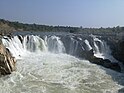
Jabalpur, formerly Jubbulpore, is a city situated on the banks of Narmada River in the state of Madhya Pradesh, India. According to the 2011 census, it is the third-largest urban agglomeration in Madhya Pradesh and the country's 38th-largest urban agglomeration. Jabalpur is an important administrative, industrial and business center of Madhya Pradesh. It is the judicial capital of Madhya Pradesh as The Madhya Pradesh High Court along with other important administrative headquarters of India and Madhya Pradesh are located in Jabalpur. It is generally accepted that the game of snooker originated in Jabalpur. Jabalpur is the administrative headquarters of Jabalpur district and the Jabalpur division. It also is a major education centre in India. The city is known for the marble rocks on the river Narmada at Bhedaghat.

<span class="mw-page-title-main">Khandwa</span> City in Madhya Pradesh, India

Khandwa is a city and a nagar nigam in the Nimar region of Madhya Pradesh, India. It is the administrative headquarters of the Khandwa district, formerly known as East Nimar District.

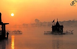
Mandla is a city with municipality in Mandla district in the Indian state of Madhya Pradesh. It is the administrative headquarters of Mandla District. The city is situated in a loop of the Narmada River, which surrounds it on three sides, and for 15 miles between Mandla and Ramnagar, Madhya Pradesh the river flows in a deep bed unbroken by rocks. The Narmada is worshiped here, and many ghats have been constructed on the banks of the river. It was a capital of the Gondwana Kingdom who built a palace and a fort, which in the absence of proper care have gone to ruins.

<span class="mw-page-title-main">Betul district</span> District of Madhya Pradesh in India

Betul district is a district of Madhya Pradesh state in central India. The city of Betul serves as its administrative headquarters. The district is a part of Narmadapuram Division.

<span class="mw-page-title-main">Harda district</span> District of Madhya Pradesh in India

Harda District is a district of Madhya Pradesh state of central India. The town of Harda is the district headquarters. The district is part of Narmadapuram Division. Harda district was organized in 1998.Harda is also known as 'Hridaynagari'.

<span class="mw-page-title-main">Rewa district</span> City and district of Madhya Pradesh in India

Rewa district is a district of the Madhya Pradesh state in central India. The city of Rewa is the district headquarter. Rewa is sometimes called – 'Land of White Tigers' as the first White Tiger was discovered here in 1951 by Maharaja of the province, Martand Singh in the nearby jungle of Govindgarh. Rewa was the capital city of once a state – Vindhya Pradesh.

<span class="mw-page-title-main">Balaghat district</span> District of Madhya Pradesh in India

Balaghat district is a district of Madhya Pradesh state in Central India.

<span class="mw-page-title-main">Chhindwara district</span> District of Madhya Pradesh, India

Chhindwara district is one of the major districts of Madhya Pradesh state of India, and Chhindwara town is the district headquarters. Chhindwara was the largest district in Madhya Pradesh with an area of 10,293 square km before the bifurcation of Pandhurna district. The district is part of Jabalpur division.

<span class="mw-page-title-main">Dindori district</span> District of Madhya Pradesh in India

Dindori District, formerly known as Ramgarh District, is a district of Madhya Pradesh state of central India. The town of Dindori is the district headquarters. The district is part of Jabalpur Division. Total area of the district is 6,128 km2 (2,366 sq mi). It is located on the eastern part of Madhya Pradesh, bordering the state of Chhattisgarh. It is surrounded by Anuppur district to the northeast, Umaria district to the north, Jabalpur district to the west, Mandla district to the southwest and Mungeli and Kabirdham districts of Chhattisgarh to the south.

<span class="mw-page-title-main">Katni district</span> District of Madhya Pradesh in India

Katni District, also known as Murwara District, is one of the 55 districts of Madhya Pradesh state in central India. The town of Katni (Murwara) is the District headquarters. The District is part of Jabalpur Division. The District occupies an area of 4949.59 km2.

<span class="mw-page-title-main">Mandla district</span> District of Madhya Pradesh in India

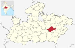
Mandla District is a district of Madhya Pradesh in central India. The town of Mandla is the administrative headquarters of the district. It is part of Jabalpur Division.

<span class="mw-page-title-main">Narsinghpur district</span> District of Madhya Pradesh in India

Narsinghpur district is a district of Madhya Pradesh state in central India. Vindhyachal is on its northern border and the Satpura range extends along its entire length on the southern border. In the northern part, the Narmada river flows from east to west. Latitude 22º.45N 23º.15N, Longitude 78º.38E 79º.38E, Area 5125.55 Square Kilometers, 359.8 meters above sea level. The city of Narsinghpur is administrative headquarters of the district. As of 2001 Narsinghpur is the most literate district of MP.

<span class="mw-page-title-main">Seoni district</span> District of Madhya Pradesh in India

Seoni District is a district of Madhya Pradesh state in central India. The town of Seoni is the district headquarters.

<span class="mw-page-title-main">Sagar district</span> District of Madhya Pradesh in India

Sagar district is a district of Madhya Pradesh state in central India. The town of Sagar serves as its administrative center.

<span class="mw-page-title-main">Anuppur district</span> District of Madhya Pradesh in India

Anuppur District (अनूपपुर) is an administrative district in Shahdol Division of Madhya Pradesh state in central India.

<span class="mw-page-title-main">Dhar district, India</span> District of Madhya Pradesh in India

Dhar district is a district of Madhya Pradesh state in central India. The historic town of Dhar is administrative headquarters of the district.

<span class="mw-page-title-main">Damoh district</span> District of Madhya Pradesh in India

Damoh District is a district of Madhya Pradesh state in central India. The town of Damoh is the district headquarters. The district is part of the Sagar Division.

<span class="mw-page-title-main">Khandwa district</span> District of Madhya Pradesh in India

Khandwa district, formerly known as the East Nimar district, is a district of the Madhya Pradesh state in central India. The city of Khandwa is the administrative headquarters of the district. Other notable towns in the district include Mundi, Harsud, Pandhana and Omkareshwar.

<span class="mw-page-title-main">Khargone</span> City in Madhya Pradesh, India

Khargone is a city and administrative headquarters of an Khargone district in the Indian state of Madhya Pradesh. The city is located on the bank of the Kunda river and is known for its cotton and chilly production. It is also known for Navgraha Mandir, a temple devoted to the nav grahas. Khargone topped the nation in municipality and received a national award for 'India's Fastest Moving City' under a population of two lakh. Khargone ranked 10th Cleanest city in India in Swachh Survekshan 2020 City ranked the 15th cleanest city in India in Swachh Survekshan 2018 and ranked 17th cleanest city in India in Swachh Survekshan 2017.

References

  1. Krishi Vigyan Kendra, Jabalpur
  2. 1 2 3 4 5 6 7 "District Census Handbook: Jabalpur" (PDF). Census of India . Registrar General and Census Commissioner of India. 2011.
  3. Wikisource-logo.svg One or more of the preceding sentences incorporates text from a publication now in the public domain :  Chisholm, Hugh, ed. (1911). "Jubbulpore". Encyclopædia Britannica . Vol. 15 (11th ed.). Cambridge University Press. p. 532.
  4. "Station: Jabalpur Climatological Table 1981–2010" (PDF). Climatological Normals 1981–2010. India Meteorological Department. January 2015. pp. 339–340. Archived from the original (PDF) on 5 February 2020. Retrieved 28 December 2020.
  5. "Extremes of Temperature & Rainfall for Indian Stations (Up to 2012)" (PDF). India Meteorological Department. December 2016. p. M120. Archived from the original (PDF) on 5 February 2020. Retrieved 28 December 2020.
  6. "Table A-02 Decadal Variation in Population Since 1901: Madhya Pradesh" (PDF). census.gov.in. Registrar General and Census Commissioner of India.
  7. US Directorate of Intelligence. "Country Comparison:Population". Archived from the original on 13 June 2007. Retrieved 1 October 2011. Kuwait 2,595,62
  8. "2010 Resident Population Data". U. S. Census Bureau. Archived from the original on 19 October 2013. Retrieved 30 September 2011. Nevada 2,700,551
  9. 1 2 "Table C-01 Population By Religion: Madhya Pradesh". census.gov.in. Registrar General and Census Commissioner of India.
  10. 1 2 "Table C-16 Population by Mother Tongue: Madhya Pradesh". censusindia.gov.in. Registrar General and Census Commissioner of India.

23°09′36″N79°56′24″E / 23.16000°N 79.94000°E / 23.16000; 79.94000