Sehore district

Last updated

Sehore District
012092021 3rd century BCE Saru Maru Panguraria Buddhist site, Madhya Pradesh 020.jpg
Natural beauty of salkanpur.jpg
Top: Stupas in Saru Maru, Panguraria
Bottom: View from Salkanpur Hill
MP Sehore district map.svg
Location of Sehore district in Madhya Pradesh
Coordinates(Sehore): 23°12′N77°05′E / 23.200°N 77.083°E / 23.200; 77.083
CountryIndia
State Madhya Pradesh
Division Bhopal
Headquarters Sehore
Tehsils 8:
  1. Sehore
  2. Ashta
  3. Budhni
  4. Bhairunda
  5. Rehti,
  6. Ichhawar
  7. Shyampur
  8. Jawar
Government
   Lok Sabha constituencies Bhopal
Area
  Total6,578 km2 (2,540 sq mi)
Population
 (2011)
  Total1,311,332
  Density200/km2 (520/sq mi)
Demographics
   Literacy 70.06%
  Sex ratio918
Time zone UTC+05:30 (IST)
Major highways Bhopal-Indore Highway
Website sehore.nic.in

Sehore District is a district of Madhya Pradesh state in central India. The town of Sehore is the district headquarters. The district is part of Bhopal Division.

Contents

Geography

Sehore is 37 km from the state capital,Sehore is situated on the Western Railway line from Bhopal to Ratlam. It is surrounded by 7 districts: Bhopal, Raisen, Harda, Hoshangabad, Dewas, Shajapur and Rajgarh.The Major rivers passing through the Sehore district is the Seevan River Kolar River and Parvati River.

Demographics

Historical population
YearPop.±% p.a.
1901234,308    
1911254,693+0.84%
1921242,362−0.50%
1931262,560+0.80%
1941278,270+0.58%
1951283,968+0.20%
1961381,286+2.99%
1971510,894+2.97%
1981657,381+2.55%
1991841,358+2.50%
20011,078,912+2.52%
20111,311,332+1.97%
source: [1]
Religions in Sehore district (2011) [2]
ReligionPercent
Hinduism
88.73%
Islam
10.52%
Jainism
0.48%
Other or not stated
0.27%

According to the 2011 census, Sehore District has a population of 1,311,332. [3] [4] [5] This gives it a ranking of 373 in India (out of a total of 640). [3] The district has a population density of 199 inhabitants per square kilometre (520/sq mi). [3] Its population growth rate over the decade 2001-2011 was 21.51%. [3] Sehore has a sex ratio of 918 females for every 1,000 males [3] and a literacy rate of 71.11%. 18.95% of the population lives in urban areas. Scheduled Castes and Scheduled Tribes make up 20.69% and 11.10% of the population respectively. [3]

Languages of Sehore district (2011) [6]

   Hindi (95.38%)
   Urdu (2.31%)
   Malvi (1.46%)
  Others (0.85%)

According to the 2011 Census of India, 95.38% of the population in the district spoke Hindi, 2.31% Urdu and 1.46% Malvi as their first language. [6]

Administration

There are 4 Assembly of Sehore districts that are governed by MLAs: [7]

There are 9 tehsils in Sehore district: Sehore Urban, Sehore Rural, Shyampur, Ashta, Jawar, Ichhawar, Bhairunda (otherwise Nasrullaganj), Budni and Rehti. [8]

Tourist places


Bijasan Mata Temple, Salkanpur

This sacred Siddhpeeth of Vindhyavasni Bijasan Devi is a very ancient temple of Goddess “Durga” situated on an 800 feet high hill in Salkanpur village of Rehti tehsil. To reach the temple, devotees have to climb 1400 stairs. [9]

Transportation

Sehore is located on Ujjain–Bhopal section it own Railway Station which connects it major city of madhya Pradesh

It's 37 km away from state capital Bhopal and welll connected with roads,

Nearby airport is Bhopal Airport ,

Notable people

Related Research Articles

<span class="mw-page-title-main">Shajapur district</span> District of Madhya Pradesh in India

Shajapur District is a district of Madhya Pradesh state of central India. The town of Shajapur is the district headquarters.

<span class="mw-page-title-main">Raisen district</span> District of Madhya Pradesh in India

Raisen District is a district of Madhya Pradesh state of India. The town of Raisen is the district headquarters. The district is part of Bhopal Division. Sanchi University of Buddhist-Indic Studies is the first international university located at Sanchi Town.

<span class="mw-page-title-main">Bhind district</span> District of Madhya Pradesh in India

Bhind district is a district in the Chambal division of the Indian state of Madhya Pradesh. The town of Bhind is the district headquarters.Bhind District is situated in Chambal region in the northwest of the state. It is surrounded by Agra, Etawah, Jalaun and Jhansi districts of Uttar Pradesh state to the north and the east, and the Madhya Pradesh districts of Datia to the south, Gwalior to the southwest, and Morena to the west. The geography of the district is characterised by uneven ravines, plain fertile fields and scanty forests. The total area of the district is 4,459 km2 (1,722 sq mi).

<span class="mw-page-title-main">Dewas district</span> District of Madhya Pradesh in India

Dewas District is a district in the Indian state of Madhya Pradesh. The town of Dewas is the district headquarters.

<span class="mw-page-title-main">Rewa district</span> City and district of Madhya Pradesh in India

Rewa district is a district of the Madhya Pradesh state in central India. The city of Rewa is the district headquarter. Rewa is sometimes called – 'Land of White Tigers' as the first White Tiger was discovered here in 1951 by Maharaja of the province, Martand Singh in the nearby jungle of Govindgarh. Rewa was the capital city of once a state – Vindhya Pradesh.

<span class="mw-page-title-main">Sidhi district</span> District of Madhya Pradesh in India

Sidhi District is one of the tribal districts of Madhya Pradesh state of India. The town of Sidhi is the district headquarters. The district is part of Rewa Division.

<span class="mw-page-title-main">Umaria district</span> District of Madhya Pradesh in India

Umaria district is a district of Madhya Pradesh. The town of Umaria is the district headquarters. The district is part of Shahdol Division.

<span class="mw-page-title-main">Guna district</span> District in Madhya Pradesh, India

Guna district is one of the 52 districts of Madhya Pradesh in central India. Its administrative headquarters is Guna. The district has a population of 1,241,519. It has an area of 6390 km², and is bounded on the northeast by Shivpuri District, on the east by Ashoknagar District, on the southeast by Vidisha District, on the southwest by Rajgarh District, on the west and northwest by Jhalawar and Baran districts of Rajasthan state. The Sindh River flows northward along the eastern edge of the district, forming part of the boundary with Ashoknagar District, and the Parvati River flows northwestward through the southern portion of the district, forming part of the boundary with Baran District before flowing into Rajasthan.

<span class="mw-page-title-main">Barwani district</span> District of Madhya Pradesh in India

Barwani district is one of the districts of Madhya Pradesh state of India. The administrative headquarters of the district is at Barwani. Barwani district has an area of 5,427 km² and a population 1,385,881. The district lies in the southwestern corner of Madhya Pradesh; the Narmada River forms its northern boundary. The Satpura Range lies to its south. The district is bordered by Maharashtra state to the south, Gujarat state to the west, Dhar District to the north and Khargone District to the east.

<span class="mw-page-title-main">Ratlam district</span> District of Madhya Pradesh in India

Ratlam District is a district of Madhya Pradesh state in central India. The town of Ratlam is administrative headquarters of the district.

<span class="mw-page-title-main">Indore district</span> District of Madhya Pradesh, India

The Indore District is a district of Madhya Pradesh state in central India. It is believed that the city is named after its Indreshwar Mahadev Temple, Where Indra is the presiding deity. The Gupta inscriptions name Indore as "Indrapura". It is also called the administrative capital. This district forms part of the Indore Division.

<span class="mw-page-title-main">Vidisha district</span> District of Madhya Pradesh in India

Vidisha District (विदिशा) is in Madhya Pradesh state, in central India. The city of Vidisha is the administrative headquarters of the district.

<span class="mw-page-title-main">Bhopal district</span> District of Madhya Pradesh in India

Bhopal District is a district of Madhya Pradesh state in central India. The city of Bhopal serves as its administrative headquarters. The district is part of Bhopal Division.

<span class="mw-page-title-main">Morena district</span> District of Madhya Pradesh in India

Morena district is one of the 52 districts of the central Indian state of Madhya Pradesh, located in the Chambal division.

<span class="mw-page-title-main">Budhni</span> Town in Madhya Pradesh, India

Budhni, also spelled Budni or Budhani, is a town and a Nagar Palika in Sehore district in the state of Madhya Pradesh, India. It is situated on Bhopal to Narmadapuram road at a distance of 7 km from Narmadapuram in north direction on the banks of Narmada River.It is also famous for Tractor testing i.e. CFMTTI (Institute under central government or Tractor Nagar.

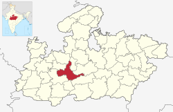
Ashta is a city and a municipality in Sehore district in the state of Madhya Pradesh, India. The nearest airport is in the city of Bhopal.

Ichhawar is a town, and a Municipal Council in Sehore district in the Indian state of Madhya Pradesh. Ichhawar is near Bhopal state capital. Nearest railway station sehore. Nearest airport Bhopal.

Nasrullaganj, also known as Bherunda or Bhairunda, is a nagar panchayat in Sehore district in the Indian state of Madhya Pradesh. The nearest airport is in Bhopal.

<span class="mw-page-title-main">Surajpur district</span> District In Chhattisgarh, India

Surajpur district is a district in the state of Chhattisgarh in central India, with its administrative headquarters at Surajpur. National Highway 43 passes through Surajpur district. Surajpur was declared a district on 15 August 2011 along with eight other new districts. Surajpur is the first district to receive National Satyan Maitra Literacy Award. The district is known for its market and other major tourist places of Chhattisgarh with Tamor Pingla Wildlife Sanctuary.

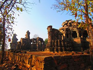
Vindhyawasini Mata Temple Salkanpur is a sacred Siddhpeeth of Vindhyavasni Beejasan Devi, located on an 800-foot summit in the village of Salkanpur, near Rehti, India. The stairs of the summit feature are around 1400.

References

  1. "Table A-02 Decadal Variation in Population Since 1901: Madhya Pradesh" (PDF). census.gov.in. Registrar General and Census Commissioner of India.
  2. "Table C-01 Population By Religion: Madhya Pradesh". census.gov.in. Registrar General and Census Commissioner of India.
  3. 1 2 3 4 5 6 "District Census Handbook: Sehore" (PDF). Census of India . Registrar General and Census Commissioner of India. 2011.
  4. US Directorate of Intelligence. "Country Comparison:Population". Archived from the original on 13 June 2007. Retrieved 1 October 2011. Mauritius 1,303,717 July 2011 est.
  5. "2010 Resident Population Data". U. S. Census Bureau. Retrieved 30 September 2011. New Hampshire 1,316,470
  6. 1 2 "Table C-16 Population by Mother Tongue: Madhya Pradesh". censusindia.gov.in. Registrar General and Census Commissioner of India.
  7. Sehore District official website: constituencies
  8. Sehore District official website: list of tehsils
  9. "'Shila Puja' for Devi Lok at Salkanpur". The Times of India. 1 June 2023.