Rajnandgaon district

Last updated

Rajnandgaon
Arieal View from Maa Bamleshwari Devi Temple on a hilltop.JPG
View of Dongargarh from Maa Bamleshwari Devi Temple on a hilltop
Rajnandgaon in Chhattisgarh (India).svg
Location in Chhattisgarh
Coordinates(Rajnandgaon): 21.10°N 81.03°E
CountryFlag of India.svg  India
State Chhattisgarh
DivisionDurg
Headquarters Rajnandgaon
Tehsils 4
Government
   Lok Sabha constituencies 1
   Vidhan Sabha constituencies 6
Area
  Total8,070 km2 (3,120 sq mi)
Population
 (2011)
  Total887,742
  Density110/km2 (280/sq mi)
   Urban
219,688
Demographics
   Literacy 77.2 per cent
  Sex ratio1023
Time zone UTC+05:30 (IST)
Average annual precipitation1274 mm
Website rajnandgaon.nic.in

Rajnandgaon is a district of the state of Chhattisgarh in central India. The administrative headquarters the district is Rajnandgaon town.

Contents

History

In ancient times Rajnandgaon, like the rest of the Chhattisgarh plain, was part of Dakshina Kosala. The region was part of the Mauryan empire during Ashoka's time. Coins of the Indo-Sassanians have been found near Rajnandgaon dating from the 3rd century CE, implying the region had indirect contact with the rest of the world. In the 4th century CE, Dakshina Kosala was one of the regions which was subdued by Samudra Gupta on his southern expedition. However it was unlikely the Guptas ever directly controlled this territory south of the Mahanadi, rather the local rulers acknowledged Gupta overlordship. Gupta coins have been found in Dakshina Kosala. Parts of the region were controlled by the Nalas of Bastar at times, while others areas were controlled by the Vakatakas for periods in the 5th century CE. [1]

In the 6th century CE, the area was under the control of the Somavamshis. In the 7th century however, the territory fell back into Nala hands. [1]

In the 10th century CE, the Somavamshis returned to power. They were soon overthrown by the Kalachuris, who claimed Haihaiya origin. In the 12th and 13th centuries CE, the southern part of the district fell into the control of chieftains from Kanker. The Kalachuris or Haihaiyavansis continued ruling the district until the 18th century CE. Khairagarh and the northern part of the district was ruled by the Raj Gonds of Garha-Mandla. After the struggle of Rani Durgavati, these rulers, as well as the Kalachuris of Raipur who ruled the southern part of the district, became vassals of the Mughals. [1]

In 1742, the Marathas under the Bhonsles of Napur invaded Chhattisgarh. The Maratha general, Bhaskar Pant, quickly overthrew the last king of the Haihaiyavansis and took over what is now Rajnandagaon district. In 1753, the Bhonsles of Nagpur confiscated all the territory that is now Chhattisgarh, and Raghoji gave the area to his son, Bimbaji, who ruled it virtually independently. [1]

The territory continued to be controlled by the Marathas until the Third Anglo-Maratha War, when it fell into British hands. In 1818, Dongargarh revolted against the British, but was quickly crushed. The British balanced the accounts of the Marathas and then returned the territory to Maratha hands. Until 1836 it was administered by a series of subadars obedient to the Nagpur state. In 1853, Nagpur was annexed by the British under the Doctrine of Lapse and Rajnandgaon fell under direct British administration under the Central Provinces and Berar. [1]

In 1906, Thakur Pyarelal Singh promoted the Swadeshi movement in the district. Later he helped organize mill workers in Rajnandgaon in a successful 34-day strike after the passage of the Rowlatt Act. For this he was punished by the authorities of Rajnandgaon state, but later wrote to the British agent to get the order cancelled. The people of the princely states participated in all the major events of the Independence movement, including the Civil Disobedience Movement that saw the British officials pass orders to quell the movement. In 1939, the people of Rajnandgaon state launched a Forest Satyagraha, in which the police fired on protestors, killing one. [1]

The Rajnandgaon remained a Princely State in independent India. In 1948, the princely state and the capital city Rajnandgaon was merged into the Durg District of Madhya Bharat, later Madhya Pradesh. Rajnandgaon district was carved out from the erstwhile Durg district on 26 January 1973. Later, Kabirdham district was carved out from this district on 1 July 1998. [2] [3]

It is a part of the Red Corridor. [4]

The collector of Rajnandgaon is Shri Doman Singh. [2]

Geography

The district covers an area of 8222 km2. The district borders Kabirdham district in the north, Bemetara, Durg and Balod districts in the east, Kanker district in the south, Balaghat district of Madhya Pradesh and Gondia and Gadchiroli districts of Maharashtra in the west.

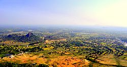
Most of the district is in the Chhattisgarh plain. This plain comprises two watersheds: that of the Wainganga in the west, and that of the Mahanadi in the east. The Shivnath, main tributary of the Mahanadi, has its source in the district, and flows through the central plain into Durg district. In the northwest, bordering Balaghat and Kabirdham districts, is the Maikal Hills, the eastern extension of the Satpuras. In the far south is the northernmost extension of the Bastar Plateau. Both the hills and plateau are sparsely populated with a majority-tribal population and retain thick forest cover, which has generally been lost in the rest of the district. [2]

Demographics

Religions in Rajnandgaon district (2011) [5]
ReligionPercent
Hinduism
93.80%
Buddhism
2.06%
Islam
1.89%
Other (tribal religion)
0.73%
Other or not stated
0.52%
Distribution of religions

According to the 2011 census Rajnandgaon district has a population of 1,537,133, [6] roughly equal to the nation of Gabon [7] or the US state of Hawaii. [8] This gives it a ranking of 325th in India (out of a total of 640). [6] The district has a population density of 191 inhabitants per square kilometre (490/sq mi) . [6] Its population growth rate over the decade 2001-2011 was 19.82%. [6] Rajnandgaon has a sex ratio of 1017 females for every 1000 males, [6] and a literacy rate of 76.97%. After bifurcation the district had a population of 884,742, of which 219,688 (24.83%) live in urban areas. The residual district has a sex ratio of 1010 females per 1000 males. Scheduled Castes and Scheduled Tribes make up 95,782 (10.83%) and 174,731 (19.75%) of the population respectively. [6]

The main Scheduled Castes are Chamar and Mahar, which make up 91% of the Scheduled Castes population. The main Scheduled Tribes are the Gonds, other major tribes are the Kawar and Halba. These three tribes make up 97% of the total Scheduled Tribes population.

Languages of Rajnandgaon district (2011) [9]

   Chhattisgarhi (82.37%)
   Hindi (13.26%)
   Marathi (1.73%)
  Others (2.64%)

At the time of the 2011 Census of India, 82.37% of the population in the district spoke Chhattisgarhi, 13.26% Hindi and 1.73% Marathi as their first language. [9]

Tourist destinations

A tehsil headquarters, Dongargarh, is the main tourist as well as pilgrimage site of the district. The famous temple of Goddess Bamleshwari, on a hilltop of 1,600 feet (490 m) in the town of Dongargarh, is referred to as Badi Bamleshwari. [10] Another temple, at ground level, is situated about 1/2 km from the main temple complex. This temple is known as Chhoti Bamleshwari. Many hundreds of thousands of people from in and around Chhattisgarh flock to the shrine during the navratris of Kavar (during Dussera) and Chaitra (during Ramnavmi). During these navratris, melas (fairs) which run 24 hours are organised in the premises of the temple.

Another site of interest is the ancient place of Mata Sheetala Devi Shakti Peetha. This temple, which dates from 2200 years ago, lies 1.5 km from the railway station. The Mandir Trust has organised the Mela of Maa Bamleshwari and a lot of devotees visit during Mela period. Chotti mata mandir reconstruction in famous pink sandstone and marble stone. Pragyagiri, a famous Buddhist Vihara is another attraction of this district. Barfani dham at Rajnandgaon town is another place of pilgrims widely visited. Other places are: Ambagarh Chowki, Ambagarh Devi Mandir, Mongara Dem, Sankar Dahara Tipagarh Pahadi.

Notable People

Villages

Related Research Articles

<span class="mw-page-title-main">Chhattisgarh</span> State in central India

Chhattisgarh is a landlocked state in Central India. It is the ninth largest state by area, and with a population of roughly 30 million, the seventeenth most populous. It borders seven states – Uttar Pradesh to the north, Madhya Pradesh to the northwest, Maharashtra to the southwest, Jharkhand to the northeast, Odisha to the east, Telangana and Andhra Pradesh to the south. Formerly a part of Madhya Pradesh, it was granted statehood on 1 November 2000 with Raipur as the designated state capital.

<span class="mw-page-title-main">Raipur district</span> District of Chhattisgarh in India

Raipur district is a district in the Chhattisgarh state of India. Its administrative headquarters is the city of Raipur. The district is rich in mineral resources and there are many wildlife sanctuaries. With a population of 2 million, it is the most populous district of Chhattisgarh.

Rajnandgaon is a city in Rajnandgaon District, in the state of Chhattisgarh, India. As of the 2011 census the population of the city was 163,122. Rajnandgaon district came into existence on 26 January 1973, as a result of the division of Durg district.

<span class="mw-page-title-main">Sambalpur district</span> District of Odisha in India

Sambalpur District is a district in the western part of state of Odisha, India. The historic city of Sambalpur is the district headquarters.

<span class="mw-page-title-main">Durg district</span> District of Chhattisgarh in India

Durg district is a district situated in Chhattisgarh, India. The district headquarters is Durg. The district covers an area of 2,238 km². As of 2011 it is the second most populous district of Chhattisgarh, after Raipur.

<span class="mw-page-title-main">Dakshina Kosala</span> Historical region of central India

Dakshina Kosala is a historical region of central India. It was located in what is now Madhya Pradesh and Chhattisgarh along with some parts of Western Odisha. At its greatest extent, it may have also included a part of the Vidarbha region in present-day Maharashtra.

<span class="mw-page-title-main">Bargarh district</span> District of Odisha in India

Bargarh District is an administrative district of Odisha state in eastern India. The city of Bargarh is its district headquarters. The district was carved out of the erstwhile district of Sambalpur on 1 April 1993.

Chhuikhadan is a city in Khairagarh-Chhuikhadan-Gandai district. Formerly, it was the part of Rajnandgaon district.

<span class="mw-page-title-main">Dongargarh</span> Town in Chhattisgarh, India

Dongargarh is a Major town of india and municipality in Rajnandgaon District in the state of Chhattisgarh, India and the site of the Bambleshwari Temple and Chandragiri Jain Temple. A prominent pilgrim destination in Rajnandgaon District, the city lies about 35 kilometres (22 mi) west from Rajnandgaon, 67 kilometres (42 mi) west from Durg and 132 kilometres (82 mi) east from Bhandara which are situated on National Highway 6. Featuring majestic mountains and ponds, Dongargarh is derived from the words: Dongarh meaning 'mountains' and garh meaning 'fort'. It is also a best tourism place in Chhattisgarh

<span class="mw-page-title-main">Kabirdham district</span> District of Chhattisgarh in India

Kabirdham district is one of the 33 administrative districts of Chhattisgarh state in central India. The district was earlier known as Kawardha district. The district is located between 21.32' to 22.28' north latitude and 80.48' to 81.48' east longitude. The district covers an area of 4,447.5 km2 (1,717.2 sq mi). The city of Kawardha is its administrative headquarters. This district is known for the Bhoramdeo temple located at a distance of 18 km from the district headquarters, Kawardha.

<span class="mw-page-title-main">Bambleshwari Temple</span>

Bambleshwari Temple is at Dongargarh in Rajnandgaon district, Chhattisgarh, India. It is on a hilltop of 1600 feet. This temple is referred as Badi Bambleshwari. Another temple at ground level, the Chhotti Bambleshwari is situated about 1/2 km from the main temple complex. These temples are revered by lakhs of people of Chhattisgarh who flock around the shrine during the Navratris of Kavar and Chaitra. There is tradition of lighting Jyoti Kalash during Navaratris here.

<span class="mw-page-title-main">Gariaband district</span> District of Chhattisgarh in India

Gariaband District is one of the 33 districts of Chhattisgarh. It has its headquarters at Gariaband town. The district was carved out of Raipur district in 2012.

<span class="mw-page-title-main">Surajpur district</span> District In Chhattisgarh, India

Surajpur district is a district in the state of Chhattisgarh in central India, with its administrative headquarters at Surajpur. National Highway 43 passes through Surajpur district. Surajpur was declared a district on 15 August 2011 by the state former Chief Minister Dr. Raman Singh along with eight other new districts. Surajpur is the first district to receive National Satyan Maitra Literacy Award. The district is known for its market and other major tourist places of Chhattisgarh with Tamor Pingla Wildlife Sanctuary.

<span class="mw-page-title-main">Barfani Dham</span> Temple in Chhattisgarh, India

Barfani Dham is a temple in the town of Rajnandgaon in the Indian state of Chhattisgarh. It is 40 kilometres (25 mi) from Durg towards Nagpur. A large Shiva Linga can be seen at the top of the temple while a large Nandi statue stands in front of it.

The Somavamshi or Keshari dynasty ruled parts of present-day Odisha in eastern India between the 9th and the 12th centuries. Their capitals included Yayatinagara and Abhinava-Yayatinagara.

<span class="mw-page-title-main">Sirpur Group of Monuments</span> Archaeological site in Chhattisgarh, India

Sirpur Group of Monuments are an archaeological and tourism site containing Hindu, Jain and Buddhist monuments from the 5th to 12th centuries in Mahasamund district of the state of Chhattisgarh, India. Located near an eponymous village, it is 78 kilometres (48 mi) east of Raipur, the capital of the state. The site is spread near the banks of the river Mahanadi.

<span class="mw-page-title-main">Dongargarh railway station</span> Railway station Chhattisgarh

Dongargarh railway station(DGG) is a busy railway station in Mumbai–Howrah rail zone in SECR. It is situated in Dongargarh town in Rajnandgaon district of Chhattisgarh state. It is a very important railway junction near Rajnandgaon railway station. It is midway between Jatkanhar railway station and Paniyajob railway station. DGG is main station to reach Bambleshwari Temple.

<span class="mw-page-title-main">Chindaka Naga</span>

The Chindaka Nagas were a dynasty that ruled over parts of modern-day Odisha and Chhattisgarh. Their kingdom was known as Chakrakota mandala and included the present-day districts of Bastar, Koraput and Kalahandi. They were constantly at war with their neighbours- the Somavamshi dynasty, the Kalachuris of Ratnapura, the Mana dynasty and the Western Chalukya Empire.

Trikalinga is a region of central-east India, mentioned in several historical sources. Its identification and its relation to the term "Kalinga" is debated among modern historians, who variously identify it as a distinct region to the west of Kalinga, a larger region comprising Kalinga and two other regions, a constituent of the greater Kalinga, or the three divisions of Kalinga proper.

<span class="mw-page-title-main">Mohla-Manpur-Ambagarh Chowki district</span> District of Chhattisgarh in India

Mohla-Manpur-Ambagarh Chowki district is one of the four new district in the state of Chhattisgarh, India announced by Bhupesh Baghel on 15th August 2021. It is carved out from existing Rajnandgaon district.

References

  1. 1 2 3 4 5 6 "District Gazetteer (Pages 1-40) | District DURG, Government of Chhattisgarh | India" . Retrieved 2 May 2021.
  2. 1 2 3 Official website of Rajnandgaon District
  3. "About District | District Rajnandgaon, Govt of Chhattisgarh, India | India" . Retrieved 30 November 2021.
  4. "83 districts under the Security Related Expenditure Scheme". IntelliBriefs. 11 December 2009. Retrieved 17 September 2011.
  5. "Table C-01 Population by Religion: Chhattisgarh". censusindia.gov.in. Registrar General and Census Commissioner of India. 2011.
  6. 1 2 3 4 5 6 "District Census Handbook: Rajnandgaon" (PDF). censusindia.gov.in. Registrar General and Census Commissioner of India. 2011.
  7. US Directorate of Intelligence. "Country Comparison:Population". Archived from the original on 13 June 2007. Retrieved 1 October 2011. Gabon 1,576,665
  8. "2010 Resident Population Data". U. S. Census Bureau. Retrieved 30 September 2011. Hawaii 1,360,301
  9. 1 2 "Table C-16 Population by Mother Tongue: Chhattisgarh". www.censusindia.gov.in. Registrar General and Census Commissioner of India.
  10. "Official Website of District Rajnandgaon tourism".

Coordinates: 21°06′N81°02′E / 21.100°N 81.033°E / 21.100; 81.033