Raigarh is a city in northern Chhattisgarh known as the 'Cultural capital of Chhattisgarh'; Raigarh is famous for its dance form “SUWA” (as Raigarh Gharana) and classical music; Raigarh is also known as Sanskritidhani. [3]
It is also known for its coal reserves and power generation for the state and the country. With a population of just about 1,50,019 (2011) it is a rapidly growing industrial city. Raigarh is one of the major rice-producing districts in India.
Rich in culture and tradition, Raigarh City is the administrative headquarters of Raigarh district. Apart from its cultural heritage, the city of Raigarh is also known for its Kosa (a fine silk) and rich deposits of coal.
Raigarh is home to one of the oldest jute mills in India and is major producer of steel, iron ore and electricity in the country. The most spoken language of the people living here are Odia, Chattisgarhi and Hindi. It is rapidly emerging as industrial city on the map of Chhattisgarh and India. [4]
Raigarh railway station is a station on the Tatanagar–Bilaspur section of Howrah-Nagpur-Mumbai line the broad gauge line. All express and some superfast trains stop here, while Gondwana express and Janshatabdi express originate at Raigarh. It is well connected with many major cities. While for other destinations, it has to depend upon Bilaspur railway station, which is a regional rail hub connected to every part of the country and 132 km from Raigarh district headquarter. Kirodimal Nagar railway station is another suburb small station of Raigarh city. Raigarh railway station serving to the people of the nearby area lie Surguja, Dharamjaigarh, Lailunga, Sarangarh. The Raigarh railway station has a good Vehicle parking facility even overnight parking can be done on need.
The nearest airport is Bilasa Devi Kevat Airport (Bilaspur Airport), just 156 km from Raigarh City.
Raigarh Airport, a private airport owned by the Jindal Steel and Power Limited is located 10 kilometres (6.2 mi) north-west of the city.
The tradition preserved by the ruling family of the erstwhile state of Raigarh maintains that the Raj Gond family migrated to this region from Bairagarh/Wariagarh of Chanda district of Maharashtra state about the beginning of the eighteenth century and first stayed at Phuljhar in Raipur district. From there Madan Singh, head of the family, migrated to Banda of the present-day Raigarh. The successor kings of Raigarh state after Maharaja Madan Singh were Maharaja Takhat Singh, Maharaha Beth Singh, Maharaja Dilip Singh, Maharaja Jujhar Singh, Maharaja Devnath Singh, Maharaja Ghansyam Singh, Maharaja Bhupdev Singh, Maharaja Natwar Singh, and Maharaja Chakradhar Singh. Truly speaking music, dance, and literature got fillip during the reign of Maharaja Bhupdev Singh and developed further during the rule of Maharaja Chakradhar Singh. [5] Prior to Indian Independence, Raigarh was capital of Princely State of Raigarh. [6]
Raigarh is located at 21°54′N83°24′E / 21.9°N 83.4°E . [7] It has an average elevation of 215 metres (705 feet). The Kelo river flows through the city, which is one of its main water sources. [8]
The minimum-maximum temperature range is 29.5 - 49 °C in summer, and 8 - 25 °C in winter.
Climate data for Raigarh (1981–2010, extremes 1951–2008) | |||||||||||||
---|---|---|---|---|---|---|---|---|---|---|---|---|---|
Month | Jan | Feb | Mar | Apr | May | Jun | Jul | Aug | Sep | Oct | Nov | Dec | Year |
Record high °C (°F) | 33.4 (92.1) | 39.4 (102.9) | 43.0 (109.4) | 46.0 (114.8) | 48.3 (118.9) | 47.2 (117.0) | 41.8 (107.2) | 39.0 (102.2) | 38.0 (100.4) | 38.6 (101.5) | 36.6 (97.9) | 34.4 (93.9) | 48.3 (118.9) |
Mean daily maximum °C (°F) | 27.9 (82.2) | 30.8 (87.4) | 35.5 (95.9) | 39.8 (103.6) | 41.4 (106.5) | 37.4 (99.3) | 32.2 (90.0) | 31.2 (88.2) | 32.2 (90.0) | 32.4 (90.3) | 30.3 (86.5) | 28.2 (82.8) | 33.3 (91.9) |
Mean daily minimum °C (°F) | 13.3 (55.9) | 16.2 (61.2) | 20.5 (68.9) | 24.8 (76.6) | 27.5 (81.5) | 26.8 (80.2) | 25.1 (77.2) | 25.0 (77.0) | 24.6 (76.3) | 22.2 (72.0) | 17.5 (63.5) | 13.1 (55.6) | 21.4 (70.5) |
Record low °C (°F) | 6.8 (44.2) | 7.8 (46.0) | 12.2 (54.0) | 14.4 (57.9) | 18.7 (65.7) | 19.5 (67.1) | 18.6 (65.5) | 18.4 (65.1) | 20.2 (68.4) | 13.4 (56.1) | 9.3 (48.7) | 6.4 (43.5) | 6.4 (43.5) |
Average rainfall mm (inches) | 16.7 (0.66) | 16.0 (0.63) | 14.3 (0.56) | 14.7 (0.58) | 34.5 (1.36) | 202.0 (7.95) | 403.5 (15.89) | 401.9 (15.82) | 230.7 (9.08) | 46.6 (1.83) | 11.3 (0.44) | 2.4 (0.09) | 1,394.7 (54.91) |
Average rainy days | 1.3 | 1.2 | 1.3 | 1.3 | 2.1 | 8.5 | 15.8 | 16.2 | 11.0 | 2.8 | 0.6 | 0.2 | 62.4 |
Average relative humidity (%) (at 17:30 IST) | 49 | 40 | 31 | 26 | 30 | 53 | 75 | 79 | 75 | 62 | 53 | 51 | 52 |
Source: India Meteorological Department [9] [10] |
Languages spoken are Chhattisgarhi, Hindi, and Odia. The demographics of the city consist mainly of people from Chhattisgarh, Odisha, Haryana and Bihar. A sizeable community of Bengali, Telugu and Marathi speaking people also live here.
As of 2011 [update] India census [11] Raigarh district had a population of 1,493,984, and the city of Raigarh a population of 137,126. Males constitute 51% of the population and females 49%. Raigarh has an average literacy rate of 87.02%, male literacy is 93.18%, and female literacy is 80.60%.
Religion in Raigarh (2011)
Average literacy rate in Raigarh district as per census 2011 is 85.22% of which males and females are 92.01% and 78.09% literates respectively. As of the 2011 Census of India, Raigarh had 55 primary schools, 37 middle schools, 9 secondary schools and 16 senior-secondary school, Shaheed Nandkumar Patel University, along with 2 arts and commerce colleges (including Kirodimal Govt. Arts and Science College ), 1 law college, 1 Medical College(Late Shri Lakhiram Agrawal Medical College ), 1 polytechnic college. [13] O.P. Jindal University and Kirodimal Institute of Technology are newer institutions in the city.[ citation needed ]
Chhattisgarh is a landlocked state in Central India. It is the ninth largest state by area, and with a population of roughly 30 million, the seventeenth most populous. It borders seven states – Uttar Pradesh to the north, Madhya Pradesh to the northwest, Maharashtra to the southwest, Jharkhand to the northeast, Odisha to the east, Andhra Pradesh and Telangana to the south. Formerly a part of Madhya Pradesh, it was granted statehood on 1 November 2000 with Raipur as the designated state capital.
Raipur ( ) is the capital city of the Indian state of Chhattisgarh. Raipur is also the administrative headquarters of Raipur district and Raipur division, and the largest city of the state. It was a part of Madhya Pradesh before the state of Chhattisgarh was formed on 1 November 2000. It is a major commercial hub for trade and commerce in the region. It has exponential industrial growth and has become a major business hub in Central India. It has been ranked as India's 6th cleanest city as per the Swachh Survekshan for the year 2021.. Raipur is ranked 7th in the Ease of Living Index 2022 and 7th in the Municipal Performance Index 2020, both by the Ministry of Housing and Urban Affairs (MoHUA).
Sakti is a city and a district in the state of Chhattisgarh. The assembly constituency number of District Sakti is 33, Earlier it was the only Education District of Chhattisgarh. There are 245 panchayats and 458 villages under Sakti district. Sakti district was formed on 15 August 2021 And came into complete district existence on 9 September 2022 by then Chief Minister Bhupesh Baghel.
Ambikapur is a city and headquarters of Surguja district in the Indian state of Chhattisgarh. It is one of the oldest cities in the state, in east-central India. Ambikapur is also the divisional headquarters of Surguja Division which consists of the six districts of Surguja, Korea, Manendragarh, Balrampur, Surajpur and Jashpur.
Rajnandgaon is a city in Rajnandgaon District, in the state of Chhattisgarh, India. As of the 2011 census the population of the city was 163,122. Rajnandgaon district came into existence on 26 January 1973, as a result of the division of Durg district.
Raigarh district is a district of the central Indian state of Chhattisgarh. Raigarh is the district headquarters.
Bilaspur is a city located in Bilaspur District in the Indian state of Chhattisgarh. Bilaspur is the Administrative headquarters of the Bilaspur District and Bilaspur Division. The Chhattisgarh High Court, located at Bodri, District Bilaspur has privileged it with the title Nyayadhani of the State. This city is the commercial center and business hub of North East Chhattisgarh region. It is also an important city for the Indian Railways, as it is the headquarters for South East Central Railway Zone (SECR) and the Bilaspur Railway Division. Bilaspur is also the headquarters of South Eastern Coalfields Limited. Chhattisgarh's biggest power plant operated by NTPC is in Sipat. PowerGrid in Sipat pools electricity from other power plants in region and transmits electricity to Delhi via one of longest HVDC line.
Bilaspur district is a district of the Chhattisgarh state of India. Bilaspur city is the headquarters of the district. As of 2011, it is the second most populous district of Chhattisgarh, after Raipur.
Korba is a city and an industrial area in Korba District in the Indian state of Chhattisgarh. Korba was part of Bilaspur District before 25 May 1998. It was later designated as a separate district for ease of administration, but is still under Bilaspur Division.
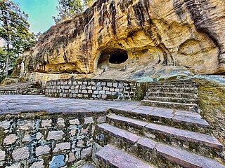
Jashpur District is a district of the central Indian state of Chhattisgarh bordering Jharkhand and Odisha. Jashpur Nagar is the administrative headquarters of the district. The district was formerly a princely state before Independence. Highly mountainous and forested, Jashpur is known for its natural environment.
Korba District is an administrative district of Chhattisgarh state in central India. The headquarter of this district is Korba. It is the Largest District in the state.
Surguja district is a district of the Indian state of Chhattisgarh. The district is one of the oldest districts of Chhattisgarh. The headquarters of the district is Ambikapur.
Dharamjaygarh is a town and a nagar panchayat in Raigarh District in the state of Chhattisgarh, India. Major languages spoken are Hindi and Chhattisgarhi, with a little Odia, Bengali and English. Laljeet Singh Rathia is a current MLA of the Dharamjaigarh constituency.
Gaurela, also known as Pendra road, is a Census town part of Gaurela-Pendra-Marwahi district in the state of Chhattisgarh, India. Gaurela and Pendra are twin cities.
Kharsia is a town and Municipality city in Raigarh District of Chhattisgarh State, India. It's also a Tehsil Headquarter.
Sarangarh is a new district in the Indian state of Chhattisgarh.
Mahasamund district is a district in Chhattisgarh state in central India. The city of Mahasamund is the district headquarters. The district is particularly famous for the historical temple town of Sirpur besides the Mahanadi river.
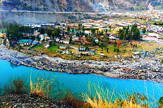
Ramban is a town in Ramban district of Jammu and Kashmir, India, which is the district headquarters of Ramban district. It lies on the banks of the Chenab river in Chenab Valley on the National Highway-1A at about 120 km from Jammu and about 130 km from Srinagar, making it almost the central point on the Jammu-Srinagar National Highway.
Raigarh was a princely state in India during the British Raj. The state was ruled by the Gond dynasty of Gond clan.