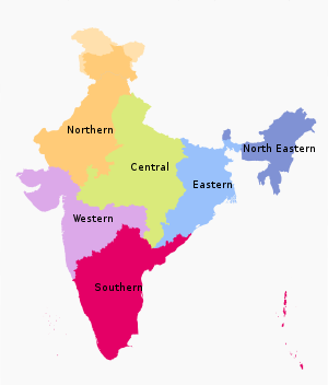
India is a federal union comprising 28 states and 8 union territories, with a total of 36 entities. The states and union territories are further subdivided into districts and smaller administrative divisions.

Vindhya Pradesh was a former state of India. It occupied an area of 23,603 sq. miles. It was created in 1948 as Union of Baghelkhand and Bundelkhand States, shortly after Indian independence, from the territories of the princely states in the eastern portion of the former Central India Agency. It was named as Vindhya Pradesh on 25 January 1950 after the Vindhya Range, which runs through the centre of the province. The capital of the state was firstly Singrauli till 1953, secondly Rewa from 1953 onwards. It lays between Uttar Pradesh to the north and Madhya Pradesh to the south, and the enclave of Datia, which lay a short distance to the west, was surrounded by the state of Madhya Bharat.
This article is about the first election held in Independent India in 1951-52.

North India is a loosely defined region consisting of the northern part of India. The dominant geographical features of North India are the Indo-Gangetic Plain and the Himalayas, which demarcate the region from the Tibetan Plateau and Central Asia.
The High Courts of India are the highest courts of appellate jurisdiction in each State and Union Territory of India. However, a high court exercises its original civil and criminal jurisdiction only if the subordinate courts are not authorized by law to try such matters for lack of pecuniary, territorial jurisdiction. High courts may also enjoy original jurisdiction in certain matters, if so designated specially by the constitution, a state or union law.

Central India is a loosely defined geographical region of India. There is no clear official definition and various ones may be used. One common definition consists of the states of Chhattisgarh and Madhya Pradesh, which are included in almost all definitions. Like some other definitions this takes the part of northern India that is "central" on an east-west axis. Thus the Central Zonal Council set up by the Indian government includes both these states, plus Uttar Pradesh and Uttarakhand to the north, the last taking the region to the border with Tibet/China in the Himalayas.
The administrative divisions of India are subnational administrative units of India; they are composed of a nested hierarchy of administrative divisions.

This is a list of proposed states and union territories in India. The constitutional power to create new states and union territories in India is solely reserved with the Parliament of India. The parliament can do so by announcing new states/union territories, separating territory from an existing state or merging two or more states/union territories or parts of them. In addition to the existing 28 states and 8 union territories, several new states and union territories have been proposed throughout India's history.
The States Reorganisation Commission (SRC) constituted by the Central Government of India in August 1953 to recommend the reorganization of state boundaries. In October 1955, after two years of study, the Commission, comprising Justice Fazal Ali, K. M. Panikkar and H. N. Kunzru, submitted its report. The commission's recommendations were accepted with some modifications and implemented in the States Reorganisation Act in November, 1956. The act provided that India's state boundaries should be reorganised to form 14 states and 6 centrally administered territories.
A union territory is a type of administrative division in the Republic of India. Unlike the states of India, which have their own governments, union territories are federal territories governed, in part or in whole, by the Union Government of India. There are currently eight union territories in India, namely Andaman and Nicobar Islands, Chandigarh, Dadra and Nagar Haveli and Daman and Diu, Delhi, Jammu and Kashmir, Ladakh, Lakshadweep and Puducherry.

The States Reorganisation Act, 1956 was a major reform of the boundaries of India's states and territories, organising them along linguistic lines.

Northern Zonal Council is a zonal council that comprises the states and union territories of Chandigarh, National Capital Territory of Delhi, Haryana, Himachal Pradesh, Jammu and Kashmir, Punjab, Rajasthan and Ladakh.

Eastern Zonal Council is a zonal council that comprises the states of Bihar, Jharkhand, Odisha, and West Bengal.

Western Zonal Council is a zonal council comprising the states of Goa, Gujarat, Maharashtra and the Union Territory of Dadra and Nagar Haveli and Daman and Diu.>

Southern Zonal Council is a zonal council that comprises the states and union territories of Andhra Pradesh, Karnataka, Kerala, Puducherry, Tamil Nadu, and Telangana

Zonal Councils are advisory councils and are made up of the states of India that have been grouped into five zones to foster cooperation among them. These were set up vide Part-III of the States Reorganisation Act, 1956.

The North-Eastern Areas (Reorganisation) Act, 1971 was a major reform of the boundaries of India's North-East region into States and union territories.


