Sarangarh

Last updated

Sarangarh
city
Sarangarh
Nickname: 
SRGH
India Chhattisgarh location map.svg
Red pog.svg
Sarangarh
Location in Chhattisgarh, India
India location map.svg
Red pog.svg
Sarangarh
Location in India
Coordinates: 21°36′N83°05′E / 21.6°N 83.08°E / 21.6; 83.08
Country Flag of India.svg  India
State Chhattisgarh
District Sarangarh-Bilaigarh
Named for Fort with Bambosa Tree
Government
  BodyNagar Palika Parishad
Elevation
217 m (712 ft)
Population
 (2014)
  Total75,000
Languages
  Official Hindi, Chhattisgarhi
Time zone UTC+5:30 (IST)
<Pin Code>
496445
Vehicle registration CG-13

Sarangarh is a New District in the Indian state of Chhattisgarh.

Contents

History

During the British Raj era, Sarangarh State was one of several princely states governed by the Raj Gond dynasty of Rajputs. It was originally a dependency of the Ratanpur Kingdom and later became one of the eighteen Garhjat states under Sambalpur State. [1]

According to legend Sarangarh state was founded in the first century AD by Gond ancestors that had migrated from Bhandara. It was originally a dependency of the Ratanpur Kingdom and later became one of the eighteen Garhjat states under Sambalpur State The Sambalpur kings favoured Sarangarh owing to its readiness to help their kingdom during military campaigns.

In 1818 Sarangarh became a British protectorate. Between 1878 and 1889 Sarangarh state was placed under the direct administration of British India owing to economic mismanagement and the infancy of the ruler Bhawani Pratap Singh. Sarangarh was a small feudatory state, part of the Chhattisgarh division.

On 1 January 1948 Sarangarh State acceded to the Indian Union.

Rulers

Sarangarh State was one of several princely states governed by the Raj Gond Dynasty of Gonds. The rulers bore the title 'Raja'. Former rulers have included:

Demographics

Dist- As of 2001 India census, [2] Sarangarh had a population of 2,14,458. Males constitute 51% of the population and females 49%. Sarangarh has an average literacy rate of 70%, higher than the national average of 59.5%: male literacy is 80%, and female literacy is 60%. In Sarangarh, 13% of the population is under 6 years of age.

Sarangarh is one of the historic and important towns of the state of Chhattisgarh. The town of Sarangarh falls within the jurisdiction of the Raigarh district of Chhattisgarh and comprises the area of the erstwhile Sarangarh Princely State. Sarangarh Town has a "Nagar Palika Parishad" comprising 15 wards. It is the headquarters of the sub-division by the same name. The town is 217 meters (711 feet) above sea level. The global location of Sarangarh falls within north latitude 21 degrees and 6 minutes to east longitude 83 degrees and eight minutes.

In accordance to the census of 2001, the population of Sarangarh is around 14,500. Sarangarh is one of the few Chhattisgarh cities and towns that have an excellent sex ratio. There are 49% females in the town and 51% males. Children under six years of age comprise almost 13% of the total population. Sarangarh has also done a considerable job in the literacy drive.[ citation needed ] The town authority and the educational department of the state have contributed in its moderate success.[ citation needed ] The town has achieved seventy percent of literacy, which is at least ten percent more than the national average. About eighty percent of males are literate while sixty percent is the female literacy rate. Some of the nearby villages are:

The Sarangarh subdivision comprises two development blocks namely Sarangarh and Baramkela. Sarangarh is located on the National Highway number 216 and is 52 km from the district HQ and rail head Raigarh, and 200 km from Raipur, the state capital and the nearest airport. The airstrip of Sarangarh is located 6 km towards Raigarh and was built during the IInd World War.

Gomarda wildlife sanctuary is located about 15 km from the town in the NH 216.

Education

Sarangarh has eight secondary level schools and two graduate and post-graduate level colleges. For technical education, there is industrial training institute.

Health

The town has a community health centre with three full-time doctors.

Members of Parliament

A new Lok Sabha constituency by the name of Sarangarh (Lok Sabha constituency) came into being after the Census of 1971. The first election for it was in 1977. However after the delimitation of political constituencies following Census 2001, this constituency ceased to exist till the time elections for Loksabha took place in 2009. The area of the Sarangarh Lok Sabha constituency was merged into Raigarh, Janjgir, and Mahasamund constituencies of Chhattisgarh.

Related Research Articles

<span class="mw-page-title-main">Sakti, Chhattisgarh</span> City in Chhattisgarh, India

Sakti is a city and a district in the state of Chhattisgarh. The assembly constituency number of District Sakti is 33, Earlier it was the only Education District of Chhattisgarh. There are 245 panchayats and 458 villages under Sakti district. Sakti district was formed on 15 August 2021 And came into complete district existence on 9 September 2022 by Chief Minister Bhupesh Baghel. The current 2018 - 2023 MLA here is Shri Charan Das Mahant, who is the Speaker of the Chhattisgarh Legislative assembly. The First Collector and District Magistrate of Sakti is Nupur Rashi Panna I.A.S, First Superintendent of Police is M.R. Ahire I.P.S and First District Education Officer is B.L. Khare, who was also the last District Education Officer of Education District Sakti.

Rajnandgaon is a city in Rajnandgaon District, in the state of Chhattisgarh, India. As of the 2011 census the population of the city was 163,122. Rajnandgaon district came into existence on 26 January 1973, as a result of the division of Durg district.

<span class="mw-page-title-main">Raigarh district</span> District of Chhattisgarh in India

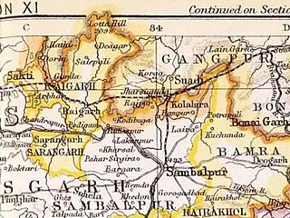
Raigarh district is a district of the central Indian state of Chhattisgarh. Raigarh is the district headquarters.

<span class="mw-page-title-main">Sambalpur district</span> District of Odisha in India

Sambalpur District is a district in the western part of state of Odisha, India. The historic city of Sambalpur is the district headquarters.

<span class="mw-page-title-main">Raigarh</span> City in Chhattisgarh, India

Raigarh is a city in northern Chhattisgarh known as the 'Cultural capital of Chhattisgarh'; Raigarh is famous for its dance form “Kathak” and classical music; Raigarh is also known as Sanskardhani.

<span class="mw-page-title-main">Bargarh district</span> District of Odisha in India

Bargarh District is an administrative district of Odisha state in eastern India. The city of Bargarh is its district headquarters. The district was carved out of the erstwhile district of Sambalpur on 1 April 1993.

<span class="mw-page-title-main">Kawardha</span> Town in Chhattisgarh, India

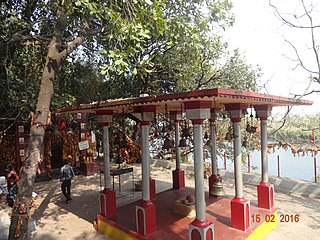
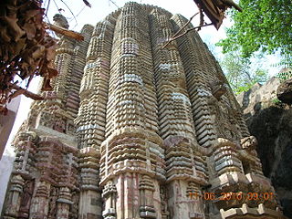
Kawardha is a town and a municipality in Kabirdham district in the Indian state of Chhattisgarh. It is the administrative headquarters of Kabirdham district. Kawardha is also known for the "Temple of Bhoramdeo."

<span class="mw-page-title-main">Mahasamund district</span> District of Chhattisgarh in India

Mahasamund district is a district in Chhattisgarh state in central India. The city of Mahasamund is the district headquarters. The district is particularly famous for the historical temple town of Sirpur besides the Mahanadi river.

Raja Nareshchandra Singh, was ruler of Sarangarh state in Raigarh District, Chhattisgarh. He also served as Chief Minister of undivided Madhya Pradesh.

Sarangarh was a Lok Sabha (parliamentary) constituency in Chhattisgarh state in central India. It was dissolved in 2009.

Pushpa Devi Singh is an Indian politician who served on the 7th Lok Sabha for the Indian National Congress party.

<span class="mw-page-title-main">Sakti State</span>

Sakti State was one of the princely states of India during the British Raj. It belonged to the Chhattisgarh States Agency, which later became the Eastern States Agency.

<span class="mw-page-title-main">Raigarh State</span> Indian princely state during the British Raj

Raigarh was a princely state in India at the time of the British Raj. The state was ruled by a Gond dynasty of Gond clan.

<span class="mw-page-title-main">Udaipur State, Chhattisgarh</span>

Udaipur State was one of the princely states of India during the period of the British Raj. The town of Dharamjaigarh was the former state's capital.

<span class="mw-page-title-main">Kawardha State</span>

Kawardha State was one of the princely states in the Central Provinces of India during the period of the British Raj. The capital of the state was Khairagarh town, in Kabirdham district of Chhattisgarh state. The Bhoramdeo Temple is located less than 20 km to the west of the main town.

<span class="mw-page-title-main">Sarangarh State</span>

Sarangarh was a princely state in India during the British Raj ruled by a Raj Gond dynasty. The emblem of the state was a turtle.

<span class="mw-page-title-main">Sambalpur State</span>

Sambalpur State, also known as Hirakhand Kingdom was a kingdom founded in 1570. It ruled over Western Odisha and Eastern Chhattisgarh in central-eastern India prior to the Maratha occupation in 1800 AD. From 1849 AD it was integrated with British Raj as a British District. Its capital was present-day Sambalpur city in Western Odisha.

<span class="mw-page-title-main">Jashpur State</span>

Jashpur State was one of the princely states of India during the period of the British Raj. The town of Jashpur was the former state's capital. The rulers were Rajputs of Chauhan Clan.

<span class="mw-page-title-main">Kanker State</span>

Kanker State was one of the princely states of India during the period of the British Raj. Its last ruler signed the accession to the Indian Union in 1947.

Paras Ram Bhardwaj was an Indian politician and a member of the 12th Lok Sabha representing Sarangarh of Madhya Pradesh State till 2000 and from Chhattisgarh State later.

References

  1. Sarangarh (Princely State)
  2. "Census of India 2001: Data from the 2001 Census, including cities, villages and towns (Provisional)". Census Commission of India. Archived from the original on 16 June 2004. Retrieved 1 November 2008.