Kondagaon district

Last updated

Kondagaon district
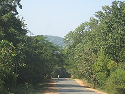
Keskal-kanker.JPG
NH-43 near Keskal
Kondagaon in Chhattisgarh (India).svg
Location in Chhattisgarh
Kondagaon district
Kondagaon district
Coordinates(Kondagaon): 19°35′N81°39′E / 19.59°N 81.65°E / 19.59; 81.65
CountryFlag of India.svg  India
State Chhattisgarh
Division Bastar
Established24 January 2012
Headquarters Kondagaon
Area
  Total7,768 km2 (2,999 sq mi)
Population
  Total578,326
  Density74/km2 (190/sq mi)
Time zone UTC+05:30 (IST)
Website https://kondagaon.gov.in/

Kondagaon district is a district of Chhattisgarh, India, and separated from Bastar district on 24 January 2012. [1] with headquarters in Kondagaon. It is mostly renowned for its bell metal craft and other art forms native to the tribal of Bastar. It is also known as the Shilp sheher (lit. craft city) of Chhattisgarh owing to the variety of indigenous crafts produced in the area.

Contents

The common name for Kondagaon is Kondanar, which means 'village of horses' in Gondi. On 15 August 2011, Chief Minister Raman Singh declared Kondagaon as a separate district.

Demographics

Religions in Kondagaon district (2011) [2]
ReligionPercent
Hinduism
83.96%
Other (Tribal religion)
14.58%
Islam
0.74%
Other or not stated
0.72%

According to the 2011 census, the population was 578,824, of which 57,983 (10.02%) live in urban areas. Kondagaon has a sex ratio of 1033 females per 1000 males and a literacy rate of 57.31%. Scheduled Castes and Scheduled Tribes make up 23,204 (4.01%) and 411,001 (71.01%) of the population respectively. [3] [4]

Languages of Kondagaon district (2011 census) [5]

   Halbi (42.41%)
   Gondi (28.04%)
   Chhattisgarhi (22.20%)
   Hindi (3.40%)
   Bhatri (1.39%)
  Others (2.56%)

At the time of the 2011 census, 42.41% of the population spoke Halbi, 28.04% Gondi, 22.20% Chhattisgarhi, 3.40% Hindi and 1.39% Bhatri as their first language. [5]

Tourism

Covered by green forest, Kondagaon is known for its natural environment and archeology.[ citation needed ] In the Keshkal block of district Kondagaon, more a dozen of waterfall and few caves have been found out a couple of years ago.[ when? ] Some of the best known waterfalls, caves, valleys and archeological sites include:[ citation needed ]

Waterfalls

Caves

Valleys

Archeological sites

Megalithic sites

Related Research Articles

<span class="mw-page-title-main">Gadchiroli district</span> District of Maharashtra in India

Gadchiroli district is an administrative district in Maharashtra, India. The city of Gadchiroli is the administrative headquarters of the district.

<span class="mw-page-title-main">Bastar district</span> District of Chhattisgarh in India

Bastar is a district in the state of Chhattisgarh in Central India. Jagdalpur is the district headquarters. Bastar is bounded on the northwest by Narayanpur District, on the north by Kondagaon district, on the east by Nabarangpur and Koraput Districts of Odisha State, on the south and southwest by Dantewada and Sukma. The district possesses a unique blend of tribal and Odia culture.

<span class="mw-page-title-main">Dantewada district</span> District of Chhattisgarh in India

Dantewada District, also known as Dantewara District or Dakshin Bastar District, is a district in the Indian state of Chhattisgarh. Dantewada is the district headquarters. The district is part of Bastar Division. Until 1998, Dantewada District was a tehsil of the larger Bastar District.

<span class="mw-page-title-main">Rajnandgaon district</span> District of Chhattisgarh in India

Rajnandgaon is a district of the state of Chhattisgarh in central India. The administrative headquarters the district is Rajnandgaon town.

<span class="mw-page-title-main">Koriya district</span> District of Chhattisgarh in India

Koriya district, officially known as Korea district, is a district in the north-western part of the Chhattisgarh state in Central India. The administrative headquarters of the district is Baikunthpur.

<span class="mw-page-title-main">Jagdalpur</span> City in Chhattisgarh, India

Jagdalpur is a city located in the southern part of Chhattisgarh state in India. It is the administrative headquarters of the Bastar district and Bastar division. Before the independence of India, it also served as the capital of the erstwhile princely state of Bastar.

<span class="mw-page-title-main">Bastar division</span> Administrative division of Chhattisgarh State, India

Bastar division is an administrative division of Chhattisgarh state in central India. It includes the districts of Bastar, Dantewada, Bijapur, Narayanpur, Sukma, Kondagaon and Kanker.

<span class="mw-page-title-main">Kondagaon</span> City in Chhattisgarh, India

Kondagaon a municipality about 70 kilometers from Jagdalpur city is the headquarter of Kondagaon district in the Indian state of Chhattisgarh. It is the third largest city of Bastar division. Kondagaon separated from Bastar district on 24 January 2012 and formed as 27th district of the Chhattisgarh state. It is mostly renowned for its bell metal craft and other art forms native to the tribal of Bastar. Also known as the Shilp sheher of Chhattisgarh owing to the variety of indigenous crafts produced in the area.

<span class="mw-page-title-main">Kanker district</span> District of Chhattisgarh in India

Uttar Bastar Kanker District is located in the southern region of the state of Chhattisgarh, India within the latitudes 20.6-20.24 and longitudes 80.48-81.48. The total area of the district is 6432 square kilometers. The population is 748,941.

<span class="mw-page-title-main">Dhamtari district</span> District of Chhattisgarh in India

Dhamtari is a district of the Indian state of Chhattisgarh. This district is situated at 20°42' N latitude and 81°33' E longitude. Dhamtari district was officially formed on 6 July 1998 by trifurcating Raipur district into Raipur, Dhamtari and Mahasamund districts.

<span class="mw-page-title-main">Bijapur district, Chhattisgarh</span> District of Chhattisgarh in India

Bijapur District, formerly known as Birjapur, is one of the 27 districts of the state of Chhattisgarh in central India. It is one of the two new districts created on May 11, 2007. As of 2011 it is the second least populous district of Chhattisgarh, after Narayanpur. It is the second-least literate district in India, with a literacy rate of at 41.58%, according to the 2011 census.

<span class="mw-page-title-main">Narayanpur district</span> District of Chhattisgarh in India

Narayanpur district is one of the 33 districts of Chhattisgarh State in Central India. It is one of the two districts created on May 11, 2007. It was carved out from the erstwhile Bastar district. This district occupies an area of 6640 km2 and it had a population of 110,800 in 2001. Narayanpur town is the administrative headquarters of this district. This district comprises 366 villages. It is currently a part of the Red Corridor.

Sirpur is a village in Kondagaon tehsil, Bastar district, Chhattisgarh, India.

<span class="mw-page-title-main">Sukma district</span> District of Chhattisgarh in India

Sukma district is the southernmost district in the Indian state of Chhattisgarh. It is located in the Bastar region, known for its tribal culture. Sukma district borders with Odisha, Telangana and Andhra Pradesh.

<span class="mw-page-title-main">Balrampur district, Chhattisgarh</span> District of Chhattisgarh in India

Balrampur-Ramanujganj district is a district in the Indian state of Chhattisgarh. It came into existence on 17 January 2012 and was formerly part of Surguja district. Balrampur-Ramanujganj district is the northernmost district of Chhattisgarh. Its seat is Balrampur.

<span class="mw-page-title-main">Tourism in Chhattisgarh</span>

Tourism is an important part of the economy of the Indian state of Chhattisgarh, India's tenth largest state. The state has many ancient monuments, rare wildlife, carved temples, Buddhist sites, palaces, water falls, caves, rock paintings and hill plateaus.

<span class="mw-page-title-main">Gaurela-Pendra-Marwahi district</span> District of Chhattisgarh in India

Gaurela-Pendra-Marwahi district is a district in the Indian state of Chhattisgarh. Gaurella is the headquarters of the district. It was carved out of Bilaspur district and inaugurated in February 2020.

<span class="mw-page-title-main">Mohla-Manpur-Ambagarh Chowki district</span> District of Chhattisgarh in India

Mohla-Manpur-Ambagarh Chowki district is one of the four new district in the state of Chhattisgarh, India announced by Bhupesh Baghel on 15 August 2021. It is carved out from existing Rajnandgaon district.

<span class="mw-page-title-main">Sarangarh-Bilaigarh district</span> District of Chhattisgarh in India

Sarangarh-Bilaigarh district is one of the four new district in the state of Chhattisgarh, India announced by Bhupesh Baghel on 15 August 2021. It is carved out from Raigarh and Baloda Bazar districts.

<span class="mw-page-title-main">Khairagarh-Chhuikhadan-Gandai district</span> District of Chhattisgarh in India

Khairagarh-Chhuikhadan-GandaiKCG is a district in the central Indian state of Chhattisgarh which consists of three cities, Khairagarh, Chhuikhadan and Gandai. It was carved out of Rajnandgaon in 2022. It is the 31st district of the state inaugurated by chief minister Bhupesh Baghel.

References

  1. "Blocks of Kondagaon, Chhattisgarh". National Panchayat Directory. Ministry of Panchayati Raj. Archived from the original on 4 October 2013.
  2. "Table C-01 Population by Religion: Chhattisgarh". censusindia.gov.in. Registrar General and Census Commissioner of India. 2011.
  3. "About District | District Kondagaon - Government of Chhattisgarh | India" . Retrieved 22 October 2020.
  4. "District Census Handbook: Bastar" (PDF). censusindia.gov.in. Registrar General and Census Commissioner of India. 2011.
  5. 1 2 "Table C-16 Population by Mother Tongue: Chhattisgarh". www.censusindia.gov.in. Registrar General and Census Commissioner of India.