Ziro is a town in and the district headquarters of the Lower Subansiri district in the Indian state of Arunachal Pradesh. It is included the Tentative List for UNESCO's World Heritage Site for the Apatani cultural landscape. The part of the town which is the centre of economic activities and where the administrative offices are located is called as Hapoli or locally known by the Apatanis as "Hao-Polyang".
Kagal is a town in Kolhapur district of the Indian state of Maharashtra.

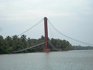
Valiyaparamba is a coastal island in Hosdurg taluk, Kasaragod district, Kerala state, India.

Zangla is a village in Zanskar tehsil of Kargil district, in the Indian union territory of Ladakh. It is located 262 km (163 mi) southeast of Kargil city, the district headquarters, and 32 km (20 mi) northeast of Padum, the headquarters of Zanskar. An ancient ruined palace, known as Zangla Fort or Zangla Khar is located on a hilltop 1 km (0.62 mi) outside the village, believed to be 11th-century. The Buddhist nunnery in Zangla contains some impressive paintings.
Chincholi is a panchayat town and a taluka in Kalaburagi district in the state of Karnataka, India.
Gurh is a town and a nagar panchayat in Rewa district in the Indian state of Madhya Pradesh. It is 23 kilometres (14 mi) from Rewa city. It is also famous for the Bhairav Baba statue.Its nearest towns are Manikwar 18 km Mangawan 25 km and Rewa District 23 km.
Jobner is a tehsil headquarter and one of the oldest municipalities in Jaipur district in the Indian state of Rajasthan.

Karnaprayag is a town and municipal board in the Chamoli District in the Indian state of Uttarakhand. Karnaprayag is one of the Panch Prayag of Alaknanda River, situated at the confluence of the Alaknanda and Pindar River.
Mangawan is a town and a nagar panchayat in Rewa district in the Indian state of Madhya Pradesh. It is 30 km (19 mi) from the District headquarters of Rewa city. NH 7 and NH 27 goes through Mangawan. Prayagraj is 96 km (60 mi) on NH 27 and Varanasi is 220 km (140 mi) on NH 7 and Manikwar is 15 km (9.3 mi)

Mauganj is the administrative headquarter of Mauganj district in Madhya Pradesh. Bagheli is the regional language of Mauganj. Mauganj is the seat of legislative assembly in Madhya Pradesh. Its nearest towns are Manikwar, Hanumana, Deotalab, Naigadhi.
Nurpur is a city and a municipal council in Kangra district in the Indian state of Himachal Pradesh. It was formerly part of the Nurpur State since the 11th century AD. The capital of the state was at Pathankot formerly known as Paithan, now in Punjab.It got its name from wife of Mughal emperor Jahangir, Nur Jahan, when they visited Kangra (Nagarkot) after Jahangir's successful conquest of the Kangra Fort.
Boungbale is a town in the Bassar Prefecture in the Kara Region of Togo. Nearby towns and villages include Bongbon, Lidialabo (1.6 km [1.0 mi]), Demon (3.2 km [2.0 mi]), Diabirdo (3.2 km [2.0 mi]), and Tipakpane (3.5 km [2.2 mi]).

The Rue Pastourelle is a street in the 3rd arrondissement of Paris.
Ampani is a town in the Kalahandi district of the state of Odisha, in India. It is a gram panchayat that comes under Kokasara tehsil. It is 15 km from its main town and blocks Kokasara.
Sosanpal is a town in Bastar district, Chhattisgarh, India.

Buttar Sivia, also known as Buttar Siviya, is a village in the Amritsar district of Punjab, India. It is predominantly inhabited by people of the Buttar, Siviya, and Randhawa Jat clans.

Wolcottsburg is a hamlet in the town of Clarence in Erie County, New York, United States.
Charoun is a village of Munger district in the Indian state of Bihar. It is situated 7 km (4.3 mi) from Munger city centre. Charoun is a part of the Munger-Jamalpur twin cities.
Turan is a small village in Phillaur tehsil of Jalandhar District of Punjab State, India. It is located 1 km (0.62 mi) away from the Apra-Banga road and 11 km (6.8 mi) away from the postal head office at Dosanjh Kalan. The village is 3 km (1.9 mi) away from the census town Apra, 16 km (9.9 mi) from Phillaur, 42 km (26 mi) from Jalandhar, and 120 km (75 mi) from the state capital Chandigarh. The village is administrated by Sarpanch who is elected representative of village.
Karanampettai is a town located in the Tiruppur district of Tamil Nadu, India. It is a suburb of Coimbatore.It lies on the National Highway 81. It is a part of Palladam taluk and Palladam which comes under the Coimbatore Parliament Constituency.


