Balaghat is known for its tile factories, rice mills and forests.[1] In MP Balaghat district has significant mineral deposits and a number of forests.[2] Balaghat comes under the Bhandara dist. Raghuji is the first Maratha who came to this place from Kirnapur Side.
History
At the beginning of the 18th century, the district was divided among two Gond kingdoms; the portion of the district west of the Wainganga was part of the Gond kingdom of Deogarh, while the eastern portion was part of the Garha-Mandla kingdom.[3]
The Deogarh kingdom was annexed by the BhonsleMarathas of Nagpur in 1743, and shortly thereafter conquered all but the northern section of the district. This section, together with the rest of the Garha-Mandla kingdom, was annexed in 1781 to the Maratha province of Saugor, then under control of the Maratha Peshwa. In 1798, the Bhonsles also obtained the former Garha-Mandla territories.[3]
In 1818, at the conclusion of the Third Anglo-Maratha War, The Nagpur kingdom became a princely state of British India. In 1853, the Nagpur kingdom, including Balaghat District, was annexed by the British, and became the new province of Nagpur. Balaghat District was then divided among the British districts of Seoni and Bhandara. Nagpur Province was reorganized into the Central Provinces in 1861.[3]
Balaghat District was constituted during the years 1867 - 1873 by amalgamation of parts of the Bhandara, Mandla and Seoni districts. The headquarters of the district was originally called "Burha" or "बूढ़ा". Later, however, this name fell into disuse and was replaced by "Balaghat", which was originally the name of the district only. Administratively, the district was divided into only two tehsils, Baihar tehsil in the north, which included the plateau region, and Balaghat tehsil in south, which included the more settled lowlands in the south. The new district was part of the Central Provinces Nagpur Division.[3]
After Indian Independence in 1947, the Central Provinces became the Indian state of Madhya Pradesh. In 1956, Balaghat District became part of the Jabalpur Division of Madhya Pradesh, when the districts to the south of Balaghat, including Old Bhandara (current Bhandara and Gondia), and Nagpur districts, were transferred to Bombay State.[citation needed]
Balaghat name signifies “above the ghats” and is due to the fact that the original purpose of Government in constituting the District was to effect the colonization of the tracts above the ghats.
In the middle of the 19th century, the upper part of the district was a lightly settled, and an ancient Buddhist temple of cut stone is suggestive of a civilization which had disappeared before historic times.[4] The first Deputy-Commissioner of the district, Colonel Bloomfield is believed as the pioneer or the creator of Balaghat District whom encouraged the settlement of Baihar tehsil with Powar from the Wainganga Valley. About that time one Lachhman Powar established the first villages on the Paraswada plateau. Malanjkhand is a copper mine in the region.[3]
In 1868-1869 the rains ceased a month before time, causing the failure of the lowland rice crop and a famine.[3] The district suffered very severely from the famine of 1896-1897,[4] when the output of all crops fell to only 17 percent of normal. The district suffered again in 1899-1900, when the rice crop failed again, falling to only 23 percent of normal. The population in 1901 was 326,521, having decreased 15% in the decade 1891-1901, due to the effects of famine.[3]
At the beginning of the 20th century, the district had only 15 miles (24km) of paved roads, together with 208 miles (335km) of unpaved roads. The Jabalpur-Gondia railway line through the district was completed in 1904, with six stations in the district.[3]
Balaghat District is currently a part of the Red Corridor.[5]
In 1845, Lord Dalhousie started the tradition of adoption (गोद लेने की प्रथा ). Through this tradition states of the Gond rulers were added to the British states, at that time the actual name of this place was BARAHGHAT. For the fixing of this name the name a proposal was sent to the capital of that time Calcutta before 1911. The name Barahghat drives because all the names of hills contain the word ghat, In which Masen Ghat, Kanjai Ghat, Ranrama Ghat, Basa Ghat, Dongri Ghat, Selan Ghat, Bhaisana Ghat, Saletekri Ghat, Dongaria Ghat, Kavahrgarh ghat, Ahmadpur ghat, Teepagarh Ghat are important. When this word was sent to Calcutta it merged with ANGL word and the name was Baraghat. When this was returned from there the name changed "L" as Balaghat means in the position of "R" which was permitted and the District got its name as Balaghat. On 1 November 1956 it was declared as Independent District of newly created State of Madhya Pradesh.
The Wainganga and its tributaries are the most important rivers in the district. The town of Balaghat is situated on the Bank of River Wainganga, which flows north to south through the district and Enters in Balaghat District by Merging with Thanwar river near Nainpur of Mandla District. The Bagh, Nahra and Uskal rivers are tributaries of the Wainganga.[4] The Bawanthadi and Bagh rivers define the boundary with Maharashtra.[citation needed]
The southern part of the Vindhyan Range up to Katangi is called Lower Bhander Range. Beyond this point the escarpment enclosing the land-locked valley of Sirampur and the hill range in continuation is called the Kaimur Range.[6]
Geographically the district is divided into three parts:
The southern lowlands, a slightly undulating plain, cultivated and drained by the Wainganga, Bagh, Deo, Ghisri and Son rivers.[4]
The long narrow valley known as the Mau Taluka, lying between the hills and the Wainganga river, and comprising a long, narrow, irregular-shaped lowland tract, intersected by hill ranges and peaks covered with dense jungle, and running generally from north to south.[4]
The plateau, in which is situated the Raigarh Bichhia tract, comprising irregular ranges of hills, broken into numerous valleys, and generally running from east to west. The highest points in the hills of the district are as follows: - Peaks above Lanji, 2300 or 2,500 feet (760m); Tepagarh hill, about 2,600ft (790m).; and Bhainsaghat range, about 3,000ft (910m). above the sea. The Banjar, Halon and Jamunia rivers, tributaries of the Narmada, drain a portion of the upper plateau.[4]
Economy
In 2006 the Ministry of Panchayati Raj named Balaghat one of the country's 250 most backward districts (out of a total of 640).[7] It is one of the 24 districts in Madhya Pradesh currently receiving funds from the Backward Regions Grant Fund Programme (BRGF).[7]
The Jabalpur-Balaghat section of South East Central Railway runs north to south through the district, along the valley of the Satpura Mountains and Wainganga River valley . The line was formerly narrow gauge (2ft6in (762mm)) for its entire length, but the section between Balaghat to Gondia was converted to broad gauge in 2005–06, connecting Balaghat to India's national broad gauge network for the first time. Work is underway to convert the Balaghat-Jabalpur section to broad gauge as well which is complete now and trains run from Vidisha to Gondia. A Broad gauge line runs to west from Balaghat to Katangi. And there is a line to Bharveli for manganese transport
According to the 2011 census Balaghat District has a population of 1,701,698,[9] roughly equal to the nation of The Gambia[10] or the US state of Nebraska.[11] This gives it a ranking of 288th in India (out of a total of 640).[9] The district has a population density of 184 inhabitants per square kilometre (480/sqmi).[9] Its population growth rate over the decade 2001–11 was 13.56%.[9] Balaghat has a sex ratio of 1021 females for every 1000 males,[9] and a literacy rate of 78.29%. 14.39% of the population lives in urban areas.
At the time of the 2011 Census of India, 40.85% of the population in the district spoke Hindi, 16.41% Marathi, 9.64% Powari, 9.35% Gondi, 5.33% Chhattisgarhi, 5.22% Lodhi and 1.18% Kalari as their first language. 9.55% of the population spoke another variety classed under Hindi.[13]
As per the 2001 Census, the total population of the district is 1,497,968, of which 1,236,083 is rural population and 129,787 is urban. Out of the total population, 113,105 are Scheduled Caste and 298,665 are Scheduled Tribes. The no. of males was 682,260 and the no. of females was 683,610. According to the District website the total area of the district is 9245km2, making the population density 162 persons per km2.[citation needed]
In the 1991 Census, the total population of the district was 1,365,870.[citation needed]
About 80% of the district's area is covered with forest. it is also the District of Madhya Pradesh which has maximum Forest Density. Teak(Tectona grandis), sal(Shorea robusta), bamboo and saja are the main trees. Fauna includes tiger, leopard, bear, nilgai, deer, and gaur, and birds like peacock, Red Bulbul and Koyal. Kanha National Park (Mukki) lies in the district.
Jabalpur, formerly Jubbulpore, is a city situated on the banks of Narmada River in the state of Madhya Pradesh, India. It is the 3rd-largest urban agglomeration of the state and the 38th-largest of the country. Jabalpur is the administrative headquarters of the Jabalpur district and the Jabalpur division. It is the judicial capital of Madhya Pradesh with Madhya Pradesh High Court being located in the city. It is generally accepted that the game of snooker originated in Jabalpur. Jabalpur is also the railway headquarters of the West Central Railway. Jabalpur Cantonment is one of the largest cantonments in India and houses the army headquarters of five states. The city is known for the marble rocks on the river Narmada at Bhedaghat. It is also known as 'Sanskardhani' meaning 'The Cultural Capital' highlighting the city's rich cultural and historical heritage. The city of Jabalpur was among the first 7 smart cities selected for the Smart Cities Mission.
The Wainganga is a river in India originating in the Mahadeo Hills in Mundara in Gondwana region near the village Gopalganj in Seoni, Madhya Pradesh. It is a key tributary of the Godavari. The river flows south in a winding course through the states of Madhya Pradesh and Maharashtra, roughly 580 km (360 mi). After joining the Wardha River, the united stream, which is known as the Pranahita River, empties into the Godavari River at Kaleshwaram, Telangana.
Mandla is a city with municipality in Mandla district in the Indian state of Madhya Pradesh. It is the administrative headquarters of Mandla District. The city is situated in a loop of the Narmada River, which surrounds it on three sides, and for 15 miles between Mandla and Ramnagar, Madhya Pradesh the river flows in a deep bed unbroken by rocks. The Narmada is worshiped here, and many ghats have been constructed on the banks of the river. It was a capital of the Gondwana Kingdom who built a palace and a fort, which in the absence of proper care have gone to ruins.
Chhindwara district is one of the major districts of Madhya Pradesh state of India, and Chhindwara town is the district headquarters. Chhindwara was the largest district in Madhya Pradesh with an area of 10,293 square km before the bifurcation of Pandhurna district. The district is part of Jabalpur division.
Seoni District is a district of Madhya Pradesh state in central India. The town of Seoni is the district headquarters.
Seoni is a city and a municipality in Seoni district in the Indian state of Madhya Pradesh. This tribal household dominated district was formed in the year 1956.
Gondia is a city and municipal council in the Indian state of Maharashtra which serves the administrative headquarters of the eponymous administrative district. Gondia is also known as Rice City due to the abundance of rice mills in the area. Gondia Airport is the only airport in the district.
Katangi is a city and a municipal council, near the city of Balaghat in Balaghat District in the Indian state of Madhya Pradesh.
Nainpur is a town and Municipal City in the Mandla district, of the Indian state of Madhya Pradesh.
Waraseoni is a tehsil and Nagar Palika Parishad (municipality) in Balaghat district in the Indian state of Madhya Pradesh. It is situated 16 km (10 mi) from the district headquarters. Waraseoni is second most populous town in Balaghat District after Balaghat.
There are 43 recognized Scheduled Tribes in Madhya Pradesh, India, three of which have been identified as "Particularly Vulnerable Tribal Groups" or "PTGs". The population of Scheduled Tribals (ST) is 21.1 per cent of the state population, according to the 2011 census. Bounded by the Narmada River to the north and the Godavari River to the southeast, tribal peoples occupy the slopes of the region's mountains.
Keolari is a town and a tehsil in Seoni district in the state of Madhya Pradesh, India. The confluence of the Wainganga and Sagar rivers is located at Keolari. The town has a District Institute of Education Training. (D.I.E.T.).
Balaghat Junction is situated on the Jabalpur–Nainpur–Gondia section of South East Central Railway, in the Indian state of Madhya Pradesh. Rail routes through the junction include routes towards Jabalpur, Gondia, Katangi on the Satpura Railway. The "10001 Satpura Express", a narrow-gauge train, was started in 1901 by the British Government and completed 100 years of service in 2001. This train used to hold the unique distinction of operating first-class service on narrow-gauge track; it was the world's fastest narrow-gauge train.
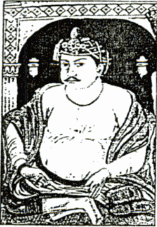
Bakht Buland Shah was a ruler of the Rajgond dynasty. He added to his kingdom, the territories of Chanda and Mandla, and portions of Nagpur, Balaghat, Seoni, Bhandara and the adjoining Rajput kingdom of Kherla/Khedla. The present districts of Chhindwara and Betul also fell under his control. A great warrior, he went on to conquer Pauni, Dongartal, Sivni, and Katangi.
Powari is an Indo-Aryan language spoken primarily in Madhya Pradesh and Eastern Maharashtra.
Lalbarra, alternatively Lalburra is a small town and serves as headquarter of Lalburra tehsil. It is a tehsil (sub-district) of Balaghat district in the state of Madhya Pradesh, India. It is located on State Highway 26, on the edge of Pench National Park. Its Postal Index Number is 481441.
The Garha Kingdom, also called Garha Mandla or Garha Katanga, was an Ancient kingdom in India. It was the first large kingdom to be founded by the RajgondsKings and was based in Central India. The kingdom was founded in the 2th century and lasted until conquest by the Maratha Confederacy in 1781.
Baihar tehsil is a fourth-order administrative and revenue division, a subdivision of third-order administrative and revenue division of Balaghat district of Madhya Pradesh.
Balaghat tehsil is a fourth-order administrative and revenue division, a subdivision of third-order administrative and revenue division of Balaghat district of Madhya Pradesh.
Chhapara or Seoni Chhapara is a town and a Nagar Panchayat in Seoni District of Madhya Pradesh.
References
Hunter, William Wilson (Sir); etal. (1908). Imperial Gazetteer of India. Vol.6. 1908-1931. Oxford: Clarendon Press. pp.??.
This page is based on this Wikipedia article Text is available under the CC BY-SA 4.0 license; additional terms may apply. Images, videos and audio are available under their respective licenses.