Kareli is a city and a Municipality in the Indianstate of Madhya Pradesh.[2] Kareli is financial capital of the district Narsinghpur. Kareli is considered as best production town for Jaggery in India . Jaggery produced in Kareli is a single kadhai Jaggery which is highly demanded in many parts of India. It is well connected by transportation. Near Kareli, an ancient fair called Barmaan Mela[3] is organised every year in the month of January on the bank of the river Narmada. There are many historic and religious places in Kareli like Chougan Quila,Deepeshwar Temple Barmaan, Deepeshwar temple is dedicated to lord Shiva. It is also taposthali (worship place) of lord Bramha. India's longest highway NH-44 (Old Name-NH-26) passes through Kareli and also connected to almost every part of the country by rail network. Before the construction of the Bina-Katni branch of the Indian Midland Railway, the metaled road from Saugor crossing the Nerbudda at Barmhan brought the bulk of the produce of the Sagar District to Kareli station. A mail cart ran from Kareli to Sagar, a distance of 122km (76mi). The trade of Kareli has now considerably declined, but it is still the exporting station for the southern parts of the Rehli tahsil of Sagar and the north of Narsinghpur. A cotton-ginning factory, the property of Raja Gokul Das, was opened in 1904. This is the nearest rail station and market for towns of Sagar district. Kareli is also educational hub for nearby area Schools like Govt. C.M.Rise School, Carmel School, Mahatma Gandhi College and many coaching institutes are situated. Agriculture based business are still doing well in the area like Kareli Sugar Mills, Dal Mills, there are many Tuar dal Mills in the city like Chacha Dal Mill, Oil plants like Shubham industries, Flour Mills like Malviya Mills, Jaggery Factories.
Kareli is a Tehsil Headquarter and a Development Block in Narsinghpur District. [4] Kareli was formerly a municipality but its municipal constitution was abolished in 1897, and the provisions of the Village Sanitation Act were introduced.
Local governance
There are 15 wards in Kareli municipality and the Nagar Palika Adhyaksha (Mayor) is the chief of the municipality.
Main villages: Dilheri, Umariya, Amgoan, Mohad, Amhenta, Jowa, Bhugwara, Pipariya, and Khiriya.
Demographics
Kareli is a Municipality city in the district of Narsimhapur, Madhya Pradesh. Kareli city is divided into 15 wards for which elections are held every five years. The Kareli Municipality has population of 29,929 of which 15,592 are males while 14,337 are females as per report released by Census India 2011.[6][7]
Population of Children with age of 0-6 is 3415 which is 11.41% of total population of Kareli (M). In Kareli Municipality, Female Sex Ratio is of 920 against state average of 931. Moreover, the child sex ratio in Kareli is around 873 compared to the Madhya Pradesh state average of 918. Literacy rate of Kareli is 86.28% higher than state average of 69.32%. In Kareli, male literacy is around 90.60% while female literacy rate is 81.62%.
Kareli Municipality has total administration over 6,490 houses to which it supplies basic amenities like water and sewerage. It is also authorized to build roads within municipality limits and impose taxes on properties coming under its jurisdiction.
Population rise of Kareli as a municipality is 18,791 in 1991, 25,043 in 2001 and 29,929 in 2011.
The sub district is home to about 1.6 lakh people, among them about 83 thousand (52%) are male and about 77 thousand (48%) are female. 72% of the whole population are from general caste, 15% are from schedule caste and 13% are schedule tribes. Child (aged under 6 years) population of Kareli tahsil is 13%, among them 52% are boys and 48% are girls. There are about 37 thousand households in the sub district and an average 4 persons live in every family. The majority of the population, nearly 76% (about 1.2 lakh) live in Kareli Sub District rural part and 24% (about 38 thousand) population live in the Kareli Sub District urban part.
Agriculture
Kareli is biggest Gur Mandi (Market of JAGGERY) of Madhya Pradesh. Sugar industry has seen a significant progress in the last decade. It is also well known for its fertile land. The black soil is suited for any kind of cultivation and there are adequate irrigation facilities. It is famous for its rich agricultural production. It is situated in the upper part of Narmada Valley, which is of much important for agriculture. The production of grains is more than the local requirement. For agriculture both old and new techniques are equally in practice. For old equipment, there are ploughs, bullock carts, bakhar, hansiya, and various types of knives and khurpi. In new methods or techniques, there are: thrashers, tractors, harvesters, electric pumps and sprinklers. Along with these better quality seeds and the best quality pesticides are used.
Crops
Mainly crops are cultivated in two seasons, Rabi and Kharif. This is based on the climate and the conditions prevails in the district by the time.
During Rabi, crops are cultivated in October–November, with cutting in April/May. The major Rabi crops are wheat, pulses, peas, alsi and masoor.
During Kharif, the farming period is June–July with cutting in October. The major Kharif crops are: paddy, jowar, bajra, makka, kondo and kutki.
The major commercial crops are soybeans and sugarcane, which is produced in large quantity and a major source of income. Soybean is used for oil extraction, and sugarcane for sugar and gur.
Industry
Being an agricultural land, large industries are rare in the area. Also most of the industrial institutions are agricultural-oriented.
Gur/sugar from sugarcane: In many places, gur has been prepared from sugarcane all over the district.
Daal Mills: Tuwar (arhar) pulses are prepared here.
Oil Mills: There are many oil mills where soybean and groundnut are extracted.
There are number of oil franchises like Madhuri, Kriti, Satyam pvt.ltd.
Other industries include cement pipes, paper mills, plastic and rubber, leather goods, earthen utensils and pots. Poultry farms, goat farming, and fish farming.
Climate
The climate is generally pleasant except in summer. Waves move slowly except during the south-west monsoon. The usual minimum temperature rests around 25–26 degrees Celsius (77–79°F), and the maximum temperature rises up to 40–45°C (104–113°F). May is the hottest month of the year. It is very excessively hot during summer, and in the end of this season dust storms come. When the monsoon arrives, the hygrometer mercury goes very low. The 90% rainfall is observed during monsoon months only; i.e., June to September. The average rainfall is of 60 days per year, and measures approximately 40 inches (1,016mm). During December–January it is cold, and the average temperature during day time is around 9°C (48°F) and 3.2°C (38°F) at night. Sometimes cold waves also occur, and heavy fog is also observed.
Tourism
Bramhan Ghat
Barman Ghat Bank of Narmada River
[8]Barman is situated at NH 44 (Srinagar-Kanyakumari Highway) and 12 kilometres (7mi) away from Kareli railway station, and the bank of river Narmada. Lord Brahma's Yagya Shala, Deepeshwar Temple, Rani Durgawati Temple, Elephant Gate and Varahas Statue are places of tourist interest there. The Narmada River flows in seven strains. It flows on the occasions of Makar Sankranti to Basant Panchami. Mela has been arranged in which District Administration also takes part. Also organized are different stalls of the district Govt. Depot. This exhibition has the display of the Agriculture Depot, co-operative, education, and health. Different beneficial schemes information and achievement have shown throes which people get benefit out of this exhibition, and also avail the district out of 20% on different sale items.[9]
Fort of Chougan/Chauragharh
The fort is 30km (19mi) from Kareli railway station. The station is of a very ancient time and not much remains of this fort which was built by Genha dynasty's King, Gond, Sangram Shah in the 15th century. One Narsinghpur district near Barheta village Nonia is also a place having archaeological importance. Here six large statues are inside Parkota, which is known as Pandav, math statue.
Literature
Kalidas Baghel (श्री प्रेम माते) is Senior Poet and well known philosopher of Kareli.
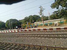
Kareli has a well connectivity with the rail network of India, located between Mumbai-Allahabad-Kolkata Rail Route, Many trains running between Mumbai, Jabalpur, Allahabad has stoppage at Kareli Railway Station.[10]
Kareli railway station is under the Jabalpur railway division of West Central Railway zone. In 1869–71, brothers Ladhha Bharmal Chawda and Ramji Bharmal Chawda of Chandiya were the main contractors for Great Indian Peninsula Railway. The railway built 153miles long railway track from Itarsi to Jabalpur. The station of Kareli along with Bagra Tawa, Sohagpur, Pipariya, Gadarwara were also built by them. With completion of this line on 7 March 1870, the Great Indian Peninsula Railway got connected with East Indian Railway network with Jubbulpore (Jabalpur) as the Junction.
Kareli has daily running trains for New Delhi, Mumbai, Kolkata, Bhopal, Indore, Jabalpur, Itarsi, Gwalior, Allahabad, Varanasi, Patna and several other places in India. The nearest junction is Itarsi (145km), one of the biggest junctions in India. Another near junction is Jabalpur (100km) which is also the zonal office of the west central rail zone.
Related Research Articles
Jabalpur, formerly Jubbulpore, is a city situated on the banks of Narmada River in the state of Madhya Pradesh, India. It is the 3rd-largest urban agglomeration of the state and the 38th-largest of the country. Jabalpur is the administrative headquarters of the Jabalpur district and the Jabalpur division. It is the judicial capital of Madhya Pradesh with Madhya Pradesh High Court being located in the city. It is generally accepted that the game of snooker originated in Jabalpur. Jabalpur is also the railway headquarters of the West Central Railway. Jabalpur Cantonment is one of the largest cantonments in India and houses the army headquarters of five states. The city is known for the marble rocks on the river Narmada at Bhedaghat. It is also known as 'Sanskardhani' meaning 'The Cultural Capital' highlighting the city's rich cultural and historical heritage. The city of Jabalpur was among the first 7 smart cities selected for the Smart Cities Mission.
Narsinghpur is a city in Madhya Pradesh in central India. It is a district under Jabalpur division. Narsinghpur has a large temple dedicated to Lord Narasimha. As of 2001, Narsinghpur is the most literate district of the state.
Itarsi is a city and municipality in Narmadapuram in Madhya Pradesh, India. Itarsi is a key hub for agricultural goods and is the biggest railway junction in Madhya Pradesh. Rail services from all 4 major metropolitan cities of India namely Mumbai to Kolkata and Delhi to Chennai pass through Itarsi. Itarsi has large number of agro-based industries and warehouses. Itarsi got its name by "eeta(eent)", and "rassi",. Bricks and ropes had been made earlier in Itarsi. It has an Ordnance Factory. The Bori Wildlife Sanctuary and Tawa Dam are nearby.
Narsinghpur district is a district of Madhya Pradesh state in central India. Vindhyachal is on its northern border and the Satpura range extends along its entire length on the southern border. In the northern part, the Narmada river flows from east to west. Latitude 22º.45N 23º.15N, Longitude 78º.38E 79º.38E, Area 5125.55 Square Kilometers, 359.8 meters above sea level. The city of Narsinghpur is administrative headquarters of the district. As of 2001 Narsinghpur is the most literate district of MP.
Hoshangabad district, officially Narmadapuram district, is one of the districts of Madhya Pradesh state of India, and Hoshangabad city is the district headquarters.
Mandi Bamora is a census town in Sagar district in the state of Madhya Pradesh, India. This place has a railway station Mandi Bamora. Mandi Bamora located as half- half way in two different district Sagar and Vidisha. Tehsil is Bina. Mandi Bamora is very famous as a name "Great country" because two different districts boundaries separated two places Bamora and Sihora.
Pipariya or Pipariya Hathwas is a town and a municipality in Hoshangabad district Indian State of Madhya Pradesh. It is also a tehsil headquarters and a Assembly Constituency.
The Economy of Madhya Pradesh refers to the economic growth with respect to the Indian state of Madhya Pradesh. It grew 12% in GDP for the year of 2011–12, for which it received an award from the President Pranab Mukherjee in January 2013 for improving its tourism, medical and infrastructural growth. The economy of Madhya Pradesh is significantly agrarian which is reflecting rapid strides towards industrial and service sectors as well. The Indore, Bhopal, chhindwara and Jabalpur districts are the top 3 districts in terms of highest output generation in the state's economy.
Banapura is a small town in the Hoshangabad District of Madhya Pradesh, India. Banapura is a twin city of Seoni Malwa.
Saugor is a railway station in Sagar city in Madhya Pradesh. It is operated by the West Central Railway, with its headquarters at Jabalpur. Saugor is a 'A' Category railway station of West Central Railway zone of Indian Railways. Saugor is a major railway station of Bina–Katni line. The station consists of two platforms. Passenger, Express and Superfast trains halt here.
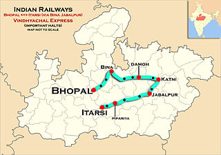
The Vindhyachal Express is an express train service offered by West Central Railways. It runs between Bhopal Junction railway station of Bhopal City, the capital of Madhya Pradesh and Itarsi Junction. The name 'Vindhyachal' signifies the Vindhyachal hill valley of Madhya Pradesh state.
The 18233 / 18234 Narmada Express is a daily express train which runs between Indore city of Madhya Pradesh and Bilaspur city of Chhattisgarh.
The 12853 / 12854 Amarkantak Express is a daily Superfast Express train which runs between the Bhopal Junction railway station in Bhopal, the capital city of Madhya Pradesh and Durg, a city in Chhattisgarh state in central India. This train replaced the 8225/8226 Bhopal–Bilaspur Mahanadi Express along with the 8291/8292 Bhopal–Raipur Express and the 1235/1236 Bhopal–Jabalpur Express.
The 12061 / 12062 Rani Kamalapati–Jabalpur Jan Shatabdi Express is a type of Jan Shatabdi Express train service offered by West Central Railway.
Adhartal - Rani Kamalapati Intercity Express is a daily Express Train of the Indian Railways, which runs between Adhartal railway station of Jabalpur, one of the important city & military cantonment hubs of Central Indian state of Madhya Pradesh and Rani Kamalapati the railway station in Bhopal, the capital city of Madhya Pradesh.
Chhindwara Junction railway station serves Chhindwara in Chhindwara district in the Indian state of Madhya Pradesh.
Gadarwara railway station is a 'B' Category railway station under West Central Railways serving Gadarwara town, in Narsinghpur district of Madhya Pradesh state of India. It is under Jabalpur railway division of West Central Railway Zone of Indian Railways.
Narsinghpur railway station is a railway station serving Narsinghpur city, in Narsinghpur district of Madhya Pradesh State of India. It is under Jabalpur railway division of West Central Railway Zone of Indian Railways. It is located on Jabalpur–Itarsi main line of the Indian Railways. Passenger, Express and Superfast trains halt here.
Lodhikheda railway station is a railway station in Lodhikheda, in the Indian state of Madhya Pradesh.It situated at the junction of Nagpur–Jabalpur and Nagpur–Chhindwara main lines.
Tendukheda is a city and a nagar panchayat in narsinghpur district, it's also a tehsil headquarter,
This page is based on this Wikipedia article Text is available under the CC BY-SA 4.0 license; additional terms may apply. Images, videos and audio are available under their respective licenses.