The name Chhindwara has been derived from the word Chhind, the local name of a tree found commonly in the district. Chhindwara district was formed on 1 November 1956.[1]
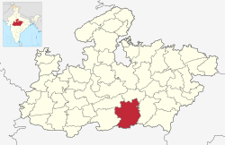
It is on the southwest region of the Satpura Range.[1] It is spread from 21.28 to 22.49 deg. North (latitude) and 78.40 to 79.24 deg. East (longitude) and spread over an area of 11,815km2. This district is bound by the plains of Pandhurna district and Nagpur district (in Maharashtra State) on the south, Narmadapuram and Narsinghpur districts on the north, Betul district on the west and Seoni district on the east.[1]
History
The early history of Chhindwara is not well-known. Based on copper-plate inscriptions found in Chhindwara and neighbouring Seoni districts, it was speculated that the Vakatakas were in power here until the 3rd century CE. By the late 7th century their power faded and the dynasty was ruled by the Gaulis. The southern part of the district, like the Nagpur plain to the south, was ruled by the Rashtrakutas for several centuries. A copper plate inscription from the 9th century CE gives a village named Mohagrama to a Kannada Brahmin, which some scholars have identified as Mohgaon in southern Chhindwara.[2]
Until the advent of the Gond dynasties in the 14th century, Chhindwara's history is scant. The western part of the district could have been part of the Kherla kingdom in nearby Betul. Deogarh on the Chhindwara plateau is believed to be the last seat of Gauli power. According to legend, founder of the Gond dynasty, Jatha slew and supplanted the Gauli chiefs Ransur and Ghamsur during a temple festival.[3] Briefly the Deogarh kingdom was the most powerful of the four Gond states, but was quickly made into a tribute-paying sarkar under the Berar subah of the Mughals. The Deogarh sarkar included parts of Chhindwara and Nagpur districts. King Bakht Bulund was most powerful in the dynasty and he has adopted Islam as his religion during the rule of Emperor Aurangzeb. By 1720, under Bakht Buland's leadership, Deogarh was largely independent from Mughal control. Bakht Buland mainly resided in Deogarh and conquered large territories from the kingdoms of Mandla and Chanda. When Aurangzeb's army was faltering, Bakht Buland took the opportunity to attack Mughal territory on both sides of the Wardha river. He and his sons encouraged the migration of many non-tribal cultivators to the Berar plains and the plateau region. After his son Chand Sultan's death, one of his illegitimate sons claimed the throne and his widow called the Marathas for aid. The Marathas conquered Deogarh and it became the territory of the Bhonsles of Nagpur.[2]
On 17 September 1803, the British East India Company had taken over this kingdom by defeating Raghoji II Bhonsle, starting the British rule. Nagpur state continued to administer the territory until in 1853 it was annexed as part of the Doctrine of Lapse. After the 1857 rebellion, Chhindwara district became part of the Nerbudda Division of the Central Provinces and Berar, which became the state of Madhya Bharat (later Madhya Pradesh) after India's independence in 1947.[4] After Independence, Nagpur was made the capital of Chhindwara District, and on 1 November 1956, when Maharashtra was formed and took Nagpur, this district was re-constituted with Chhindwara as the capital.
Geography
Geographically, Chhindwara district can be divided into three main regions:
The western region consists two major towns: Junnardeo and Parasia;
The central region consists of Chhindwara, southern part of Amarwara region, Bichhua and Mohkhed region. It is a plateau region.
The northern region is in the highest part of the Satpura Range, and covers a small portion of the plains of the Narmada valley.
The altitude of the district varies from 1,550ft (470m) to 3,820ft (1,160m) above sea level with an average elevation of 2215 feet (675 m).
The Kanhan River flows in a southern direction through the western parts of Chhindwara Tehsil and enters the Wainganga River. The Jam River flows mostly through the Sausar region and joins with the Kanhan River. The Pench River flows in the border areas of Chhindwara and Seoni districts and mixes with the Kanhan River in Nagpur District. The Kulbehra River starts at Umreth and flows through Chhindwara and Mohkhed and joins with Pench River.
Over a third of the district, around 4212.556km2 of the district is covered under forest. Bamboo, teak, harra, saalbeej, and tendu patta are the major commercially harvested forest products.
According to the 2011 census Chhindwara District has a population of 2,090,922,[7] This gives it a ranking of 218th in India (out of a total of 640).[7] The district has a population density of 177 inhabitants per square kilometre (460/sqmi).[7] Its population growth rate over the decade 2001-2011 was 13.03%.[7] Chhindwara has a sex ratio of 966 females for every 1000 males,[7] and a literacy rate of 72.21%. 24.16% of the population lives in urban areas. Scheduled Castes and Scheduled Tribes made up 11.11% and 36.82% of the population respectively.[7] The main Scheduled Tribes are Gonds and Mawasi Korkus. Gonds make up 80% of the total Scheduled Tribe population and over 30% of the district overall.
There are 1,984 villages in the district, out of which 1,903 villages are inhabited. It is divided into 19 Revenue Circles, 319 Patwari Halkas. There are 808 Panchayats in the district. Chhindwara is the Parliamentary Constituency in the district and there are eight assembly segments (Junnardeo, Chhindwara, Parasia, Damua, Amarwara, Chourai, Sausar and Pandhurna). As per Census 2001 the population of Chhindwara town was 1,22,309 and of the district is 18,48,882 with a population density of 156 people per km2. There are 953 females for every 1000 males.
The sex ratio of rural Chhindwara is more (962) than that of urban Chhindwara (926). As per Census 2001, the average literacy rate of the district was 66.03%, which is above the average of the MP state's 64.08%. The literacy rate in the rural area of the district is 60.76% and that of urban area is 81.46%.
Hindi is the primary language throughout the district . The local dialect in Chhindwara a variant of western Hindi related to Bagheli. Pawari is a name for a dialect of spoken by the Kshatriya Pawar/Bhoyar community in this region . Marathi is the dominant language in the regions of Pandhurna and Sausar. There are several known Maharashtra mandals that keep Marathis connected throughout. Gondi was formerly spoken by over 30% of the population in 1931, and over 75% of Gonds. This percentage has decreased rapidly as most Gonds have shifted to Hindi. Today, it is only spoken by shrinking minorities in Junnardeo, Mokhed, Pandhurna, Sausar and Bicchua tehsils and has vanished everywhere else. Korku, primarily the Mawasi dialect, is mainly spoken in Mokhed and Sausar tehsils and is experiencing a similar steep decline. In Patalkot, Tamia tehsil, is spoken the poorly-known Bharia language, an unclassified Indo-Aryan language. All three tribal languages are highly endangered.
Chhindwara has a subtropical climate bordering tropical wet and dry climate. Like most of north India, it has a hot, dry summer (April–June) followed by monsoon rains (July–September) and a cool and relatively dry winter. Average annual rainfall is 1,183mm. Minimum temperature during winter is 4 to 6 degrees Celsius while maximum temperature during summer is 38 to 42 degrees Celsius.
Media
Newspapers: Chhindwara has a few print publications which include Hindi newspapers such as, Dainik Bhaskar, Lokmat Samachar, Patrika, Divya Express and a recent web publication called news4india.
Hindustan Unilever Limited is a multinational company, originally from England. Earlier this company's name was Hindustan Lever Limited. Chhindwara Hindustan Unilever Limited is in village Lahgadua, 5km from Chhindwara. This company completed 75 years in 2008. There are 210 workers in Hindustan Unilever, who work in three shifts. The Chhindwara factory produces three main products: Rin washing soap, Wheel washing powder, and Surf Excel washing powder. It is the only factory of Hindustan Unilever in Madhya Pradesh. In 2007 the production was 70,000 units.[citation needed]
The Raymond Chhindwara plant, set up in 1991, is a state-of-the-art integrated manufacturing facility located 65km from Chhindwara now in Pandhurna district. Built on 100 acres (0.40km2) of land, the plant produces premium pure wool, wool blend, and polyester viscose suiting. This plant has achieved a record production capacity of 14.65 million meters, giving it the distinction of being the single largest integrated worsted suiting unit in the world.
Spices Park:—
India's first spice park was opened in Chhindwara on 25 February 2009. The first in a series of seven parks planned by the Spices Board is being set up with an investment of Rs 20 cr. The initial phase of the park consists of a Garlic Dehydration Plant set up by the Spices Board and a Steam Sterilization Unit set up by STCL Ltd., a public sector company. KITCO are the technical consultants for the project. The park has come up in an area of 18 acres (73,000m2) in Laas village, Umranala, near Chhindwara in Madhya Pradesh on Chhindwara-Nagpur Highway.
Nakoda Group:—
This group is medium scale and fast growing industrial group of Chhindwara now in Pandhurna district . Unit exist in Borgaon industrial area near Raymond Group. Led By Mr. Mayank Kothari and Mr. Ritesh Jain this group is expanding and raising job opportunity for local public and has given jobs to more than 200 people in the last three years.
Amongst other large scale industries are Super Pack (Bajaj) at Village Sawli near Sausar, district Pandhurna and Bhansali Engineering Polymers at village Satnur near Sausar, P.B.M. Polytex Ltd. at village Borgaon near Sausar and Suryawanshi Spinning Mills at village Rajna near Pandhurna.
Coal mines
Junnardeo, about 50km from Chhindwara, is the head office of the Kanhan area of WCL. It has Asia's largest coal wash plant. It has around 15 coal mines in the Kanhan area. It has a big railway coal transportation and its own importance in railways.
Parasia, about 30km from Chhindwara, is known as the "Coal Mines Belt". There were 24 mines in this area, of which 20 mines are still working. The principal mines are Eklehara Mines, Barkuhi Mines, Chandameta Mines, Newton Mines, Donger Chikhali Mines, Mahadev Puri Mines. Ravanwara Mines, Ravanwara Khash, Vishnu Puri 11 No., Vishnu Puri 12 No., Chhinda Mines, Setiya Mines, Shivpuri Mines, Shivpuri Mines, Chhury Mines, Mathani Mines, Thisgora Mines, Nahariya Mines, Pench Mines, and Urdhan Project.
Tourist places
Following Prominent Tourist Spots in the District. The unique fair of stone Gotmaar mela of Pandhurna is also attractive for the tourist all around the world.
Pataleshwara is a famous temple in Chhindwara. This is a Lord Shiva temple where the Shivratri Mela is held. In Chhindwara a shivling find out in "Ground". This shivling was seen before 250 years.
Pench National Park
The Pench National Park or Pench Tiger Reserve is named after the Pench River, which flows from north to south through the reserve in the southern reaches of the Satpura hill ranges in the Seoni and Chhindwara districts of Madhya Pradesh. The terrain is undulating, with most of the area covered by small hill ranges, steeply sloping on the sides. The reserve is in an area that holds a significant place in the natural history of Central India.
The description of its landscape, flora, and fauna has appeared in wildlife books dating back to the 17th century. Books written in the 19th and early 20th century by naturalists such as Captain J. Forsyth and Rudyard Kipling's Jungle Book explicitly present a detailed panorama of this tract.[citation needed]
Related Research Articles
The Satpura Range is a range of hills in central India. The range rises in eastern Gujarat running east through the border of Maharashtra and Madhya Pradesh and ends in Chhattisgarh. The range parallels the Vindhya Range to the north, and these two east–west ranges divide Indian Subcontinent into the Indo-Gangetic plain of northern India and the Deccan Plateau of the south. The Narmada River originates from north-eastern end of Satpura in Amarkantak, and runs in the depression between the Satpura and Vindhya ranges, draining the northern slope of the Satpura range, running west towards the Arabian Sea. The Tapti River originates in the eastern-central part of Satpura, crossing the range in the center and running west at the range's southern slopes before meeting the Arabian Sea at Surat, draining the central and southern slopes of the range. Multai, the place of Tapi river origin is located about 465 kilometer far, south-westerly to Amarkantak, separated across by the hill range. The Godavari River and its tributaries drain the Deccan plateau, which lies south of the range, and the Mahanadi River drains the easternmost portion of the range. The Godavari and Mahanadi rivers flow into the Bay of Bengal. At its eastern end, the Satpura range meets the hills of the Chotanagpur Plateau. The Satpura Range is a horst mountain and is flanked by Narmada Graben in the north and much smaller but parallel Tapi Graben in the south.
Chhindwara is a city in India and a Municipal Corporation in Chhindwara district in the Indian state of Madhya Pradesh. The city is the administrative headquarters of Chhindwara District. Chhindwara is reachable by rail or road from adjacent cities Betul, Jabalpur and Nagpur. The nearest airport is in Nagpur (130 km); however there is a small airport located in the city which is not serviceable for passenger planes.
Balaghat district is a district of Madhya Pradesh state in Central India. Its belongs to Jabalpur Division. Balaghat city is Administrative Headquarter of Balaghat District.
Seoni District is a district of Madhya Pradesh state in central India. The town of Seoni is the district headquarters.
Seoni is a city and a municipality in Seoni district in the Indian state of Madhya Pradesh. This tribal household dominated district was formed in the year 1956.
Amarwara is a tehsil and a Nagar Palika Parishad in Chhindwara district in the state of Madhya Pradesh, India.
Damua is a census town in Chhindwara district in the state of Madhya Pradesh, India.
Parasia, formerly known as Dongar Parasia, is a tehsil and a municipality in Chhindwara district in the state of Madhya Pradesh, India.
Sausar (Saunsar) is a Municipal Council in the central India in the state of Madhya Pradesh. Sausar lies in Vidharbha region, Nagpur is the center for all the economic activities in this region which is just 72 km from Sausar. More than 90 per cent of farmers produce oranges. Cotton is grown in large quantities in the local area.
Deogarh, also known as Devgarh, is a village in Mohkhed tehsil of Chhindwara District of the Indian state of Madhya Pradesh. It is located 24 miles southwest of Chhindwara, picturesquely situated on a crest of the hills. It was the centre of the Gond kingdom of Deogarh.
Barkuhi is a small township in Chhindwara District in the Indian state of Madhya Pradesh.
Pench Kanhan Coalfield is located in Chhindwara District in the Indian state of Madhya Pradesh.
Ajanbahu Jatbasha is considered by historians to be founder of the Gond dynasty of Chhindwara and Nagpur, which ruled the present days territories of Madhya Pradesh, Chhattisgarh and part of Maharashtra in the 16th-18th centuries. Documentation of his origins and rise to power have not survived, but he is the first historical leader of the mountain Gondi people.
The Pench River is an Indian tributary of the Kanhan River. It originates in the Chhindwara district of Madhya Pradesh and flows across Pench National Park, which is a reserve for the Tiger Project of India.
The Kanhan River is an important right bank tributary of the Wainganga River draining a large area lying south of Satpura range in central India. Along its 275 km run through the Indian States of Maharashtra and Madhya Pradesh, it receives its largest tributary - Pench River, a major water source for the metropolis of Nagpur.
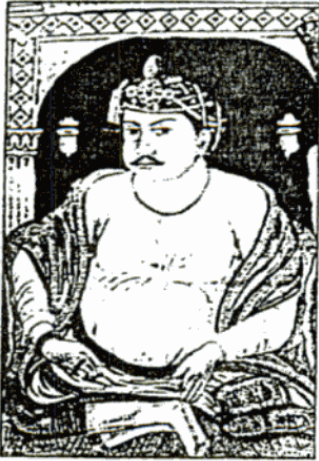
Bakht Buland Shah was a ruler of the Rajgond dynasty. He added to his kingdom, the territories of Chanda and Mandla, and portions of Nagpur, Balaghat, Seoni, Bhandara and the adjoining Rajput kingdom of Kherla/Khedla. The present districts of Chhindwara and Betul also fell under his control. A great warrior, he went on to conquer Pauni, Dongartal, Sivni, and Katangi.
Junnardeo, formerly known as Jamai, is a city and a municipality in Chhindwara district in the Indian state of Madhya Pradesh, India. Junnardeo is the head office of the Kanhan area of WCL. It has Asia's largest Coal Wash Plant.
The Gonds of Deogarh were a Gond royal house that ruled large parts of the Vidarbha region and parts of present-day southern Madhya Pradesh. Their Kingdom consisted of the area which later became the Nagpur Kingdom. They made Nagpur region a prosperous and plentiful kingdom, founding the city of Nagpur and building further infrastructure. However, internal bickering led to their decline and they were practically made state pensioneries by the Maratha general Raghoji I Bhonsle in the 1743.
The siege of Nagpur was laid by Khan-i-Dauran, a high-ranking Mughal official to the fort of Nagpur, ruled by the Gond king of Deogarh, Kok Shah.
Umranala or Ekalbihari is a small town in Mohkhed tehsil of Chhindwara District of Madhya Pradesh. It has its own railway station.
This page is based on this Wikipedia article Text is available under the CC BY-SA 4.0 license; additional terms may apply. Images, videos and audio are available under their respective licenses.