Darna River

Last updated

Darna river
Location
Country India
State Maharashtra
District Nashik
City Nashik
Physical characteristics
SourceKulang hill
  location Sahyadris, Nashik, North Maharashtra, Maharashtra, India
  coordinates 19°58′27″N73°56′12″E / 19.97417°N 73.93667°E / 19.97417; 73.93667
Mouth Godavari River
  location
Darnasangvi, Nashik, Khandesh, Maharashtra
  coordinates
19°10′46″N73°02′24″E / 19.17944°N 73.04000°E / 19.17944; 73.04000
  elevation
550 m (1,800 ft)
Length80 km (50 mi)
Basin features
Tributaries 
  leftVaki River, Aaundha River, Waldevi River
  rightKadva river

Darna is a minor right-bank tributary of Godavari in the Nashik District, Maharashtra, India. Rising north of the Kalsubai range, it drains Igatpuri, Nashik and Niphad Talukas of Nashik District. The conjunction with Godavari is situated at Darnasangvi.

Contents

Origin

The Darna rises on the northern slopes of the Kulang hill fort in the Sahyadris about 13 km. south-east of Igatpuri.

Course

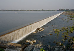
Though the straight line distance from the source to its confluence with the Darna is only about 50 km., it has a very long and winding course which measures about 80 km. [1] Its banks are like those of the Godavari below Nashik, of no great height, but broken by scores of small streams, making the passage along the banks of the river very difficult for laden carts. It is crossed by a bridge at Chehedi on the Nasik-Pune road, on the way to Sinnar. The bed is for the most part wide and sandy, though at times, the water flows over rocks. The Darna Dam is constructed across the Darna near Nandgaon village giving rise to the storage known as Lake Beale, which is visible for considerable distance while travelling by train from Mumbai to Nasik on the right hand side. This has enabled the construction of a pick-up weir on the Godavari river at Nandur-Madhmeshwar to divert the water into the Godavari canals.

On the right bank, at Belu, the river Darna receives the Kadva, not the large river of that name, but a small stream flowing north-eastwards between Mhordan-Katlia hills on the west and Kalsubai-Bitangad-Patta range on the east in the south-eastern part of Igatpuri taluka. On the left bank the Darna has only three tributaries of any size, and they hold little water during the hot season. They are the Waki, the Unduhol and the Valdevi. [2]

Tributaries

Dams

See also

Related Research Articles

<span class="mw-page-title-main">Godavari River</span> River in south-central India

The Godavari is India's second longest river after the Ganga river and drains the third largest basin in India, covering about 10% of India's total geographical area. Its source is in Trimbakeshwar, Nashik, Maharashtra. It flows east for 1,465 kilometres (910 mi), draining the states of Maharashtra (48.6%), Telangana (18.8%), Andhra Pradesh (4.5%), Chhattisgarh (10.9%) and Odisha (5.7%). The river ultimately empties into the Bay of Bengal through an extensive network of distributaries. Measuring up to 312,812 km2 (120,777 sq mi), it forms one of the largest river basins in the Indian subcontinent, with only the Ganga and Indus rivers having a larger drainage basin. In terms of length, catchment area and discharge, the Godavari is the largest in peninsular India, and had been dubbed as the Dakshina Ganga.

<span class="mw-page-title-main">Nashik</span> Metropolis in Maharashtra, India

Nashik, Marathi: [naːʃik], formerly Nasik) is a city in the northern region of the Indian state of Maharashtra. Situated on the banks of the river Godavari. The population of Nashik city is around 2.2 million and is emerging as one of the fastest-growing cities in India. Nashik is located about 165 km (103 mi) northeast of the state capital Mumbai, and about 210 km (130 mi) north of Pune. The Mumbai-Pune-Nashik region is called the "Golden Triangle of Maharashtra". With its high agricultural production, Nashik is dubbed the Napa Valley of India and the "Wine Capital of India" as more than half of India's vineyards and wineries are located here. Around 90% of all Indian wine comes from the Nashik Valley. Nashik is one of the Hindu pilgrimage sites of the Kumbh Mela, which is held every 12 years.

<span class="mw-page-title-main">Kalsubai</span> Mountain in India

Kalsubai is a mountain in the Western Ghats, located in the Indian state of Maharashtra. Kalsubai is the highest peak in Maharashtra and is located in Ahmednagar district in Akole Taluka. Its summit, situated at an elevation of 1,646 metres (5,400 ft), is the highest point in Maharashtra. Hence, known as the Everest of Maharashtra.

<span class="mw-page-title-main">Wainganga River</span> Major River in Central India, India

The Wainganga is a river in India originating in the Mahadeo Hills in Mundara in Gondwana region near the village Gopalganj in Seoni, Madhya Pradesh. It is a key tributary of the Godavari. The river flows south in a winding course through the states of Madhya Pradesh and Maharashtra, roughly 580 km (360 mi). After joining the Wardha River, the united stream, which is known as the Pranahita River, empties into the Godavari River at Kaleshwaram, Telangana.

<span class="mw-page-title-main">Nashik district</span> District of Maharashtra in India

Nashik district, also known as Nasik district, is a district in Maharashtra, India. The city of Nashik is the administrative headquarters of the district. Nashik is well known for the production of wine. Nashik is also known as Mini Maharashtra, because the climate and soil conditions of Surgana, Peth, Igatpuri resembles with Konkan. Niphad, Sinnar, Dindori, Baglan blocks are like Western Maharashtra and Yeola, Nandgaon, Chandwad blocks are like Vidarbha Region. Nashik is the biggest city in the district while Malegaon is the second biggest city. Manmad, Igatpuri, and Sinnar are some of the big cities situated in the Nashik District. Manmad is one of the biggest railway junctions in India while the city of Malegaon is famous for its powerloom.

<span class="mw-page-title-main">Bhandardara</span> Village in Maharashtra, India

Bhandardara is a holiday resort village near Igatpuri, in the western ghats of India. The village is located in the Akole tehsil, Ahmednagar district of the state of Maharashtra, about 185 kilometers (115 mi) from Mumbai, 155 kilometers (96 mi) from Ahmednagar and 73 kilometers (45 mi) from Nashik.

Vaijapur is a city and a municipal council in Aurangabad district in the Indian state of Maharashtra. It is bordered by the Nashik districts to the west, Kannad tehsil to the north, Gangapur tehsil to the east, and Ahmednagar districts to the south. Vaijapur is the headquarters of Vaijapur tehsil and also known as the Gateway of Marathwada.

Akole is a city and Taluka in Akole tehsil, Ahmednagar district in the state of Maharashtra, India. Akole is surrounded by the Sahyadri Mountains of Western Ghats. Several historical sites in the city honor Akole's connection to the history and culture of Maharashtra.

<span class="mw-page-title-main">Manjira River</span> Tributary of river Godavari

The Manjara River is a tributary of the river Godavari. It passes through the states of Maharashtra, Karnataka and Telangana. It originates in the Balaghat range of hills near the Ahmednagar district at an altitude of 823 metres (2,700 ft) and empties into the Godavari River. It has a total catchment area of 30,844 square kilometres (3,084,400 ha). This river is one of the Triveni Sangam.

<span class="mw-page-title-main">Abhona</span> Village in Maharashtra

Abhona is a village in Kalwan tehsil of Nashik district in the Indian state of Maharashtra. It belongs to the North Maharashtra region.

Nashik District, a district in Maharashtra, India, is noted for the mountains and hills occupying the north and north-east of its territory. These hill ranges are eastward spurs of the Western Ghats and form prominent landmarks in the district, some noted for the shrines they harbor while others for the trekking adventures which can be undertaken while ascending the peaks. Broadly categorized, the hills can be segregated into 3 noteworthy ranges:

<span class="mw-page-title-main">Trimbakeshwar Range</span> Mountain range in Maharashtra, India

Trimbakeshwar Range is a mountain range in the Western Ghats of Maharashtra entirely situated in Nashik District. The range lies 30 km southwest to the district headquarters Nashik. The saddle shaped depression of the Brahmagiri mountain protects Trimbak, a town considered holy by Hindus Devotees throng to this town to pay visit to the sacred Trimbakeshwar Shiva Temple. The northern face of the range is the birthplace of India's 2nd longest river Godavari.The southern face of these hills are covered with dense forests and thus form a catchment area for the Upper Vaitarna Reservoir, the most important and reliable source of potable water supply to the metropolitan city of Mumbai. Trimbakeshwar range also contain the Anjaneri hills though a minority of authors consider the latter to be a distinct range and often prefer to use the synonym Trimbak-Anjaneri to avoid disambiguation.

<span class="mw-page-title-main">Purna River (tributary of Godavari)</span> River in Maharashtra, India

The Purna River is a major left-bank tributary of Godavari River originating in the Ajanta Range of hills in Aurangabad District, Maharashtra.The river lies in the rain shadow region of Maharashtra, on the Deccan Plateau, flowing through the districts of Aurangabad, Buldana, Jalna, Hingoli and Parbhani with a large catchment area measuring about 15,579 km2. This enormous catchment area is often tagged as a sub-basin of Godavari River and along with its tributaries forms a dendritic drainage pattern. It is a prime river in the Marathwada region of Maharashtra running for about 373 km before it converges with Godavari River south of Purna city in the Parbhani district.

<span class="mw-page-title-main">Pravara River</span> River in Maharashtra, India

The Pravara is the smallest of the major tributaries of Godavari river located in Maharashtra, India. Among the 7 major tributaries, it is the only tributary which originates in the Western Ghats akin to Godavari. Also, it is the only major tributary of Godavari to have both its source and confluence located within the same district - Ahmednagar.

<span class="mw-page-title-main">Sindphana River</span> River in Maharashtra, India

Sindphana is a minor tributary of Godavari river that originates around the Chincholi hill in Patoda Taluka, Beed District, Maharashtra, in India. Crossing west to east its drainage basin covers nearly 80% of Beed District, making it the most important river within the district. The Majalgaon Dam, constructed across the river, irrigates 93885 hectares of land in Beed, Parbhani & Nanded districts.

Nandini is an insignificant tributary of the river Godavari which runs its course through the city of Nashik, Maharashtra.

Banganga is a small tributary of the Godavari River in the Nashik district, in the state of Maharashtra in western India.

Kadva river is a minor but important tributary of Godavari in Nashik district, Maharashtra, India. It originates and flows through the Dindori Taluka of Nashik District.

<span class="mw-page-title-main">Shivana River</span> River in Maharashtra, India

Shivana River is a minor but important tributary of Godavari lying entirely within Aurangabad district, Maharashtra. It rises in the Kannad taluka, from the south-western slope of the Ajanta Hills which also holds the origin to another major tributary Purna.

Bitangad Fort is a fort in Nashik district in the Igatpuri taluka in Maharashtra state of India.

References

  1. Anilkumar Pathare (2013). Geographical study of tribal population characteristics in Nashik district Maharashtra (PhD thesis). Tilak Maharashtra Vidyapeeth. hdl:10603/23522.
  2. "Official WebSite of Nashik District". Archived from the original on 3 July 2015. Retrieved 14 October 2015.