This article needs to be updated.(August 2014) |
| Oshiwara River | |
|---|---|
 Filth choking Oshiwara river in Jan 2006 | |
 The Oshiwara River is in the north face | |
| Location | |
| Country | India |
| State | Maharashtra |
| City | Mumbai |
| Physical characteristics | |
| Source | Aarey Milk Colony |
| • location | Mumbai suburban district, India |
| Mouth | |
• location | Arabian Sea, |
• coordinates | 19°09′33″N72°48′59″E / 19.15917°N 72.81639°E |
• elevation | 3 m (9.8 ft) |
| Length | 7 km (4.3 mi) |
| Basin size | 29.38 km2 (11.34 sq mi) |
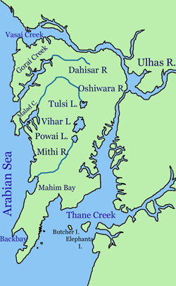
Oshiwara River is a river in Mumbai, India. It begins in the Aarey Milk Colony, [1] cuts through the Goregaon hills, across the Aarey Milk Colony before emptying into the Malad Creek. On the way it is joined by another creek near Swami Vivekanand Road, before picking up industrial effluents and sewage while crossing the Oshiwara industrial estates and slums of Andheri. Most of the call centres in Malad have been built on reclaimed ground at the mouth of the river.