Geography of Mumbai

Last updated

Rivers and lakes of the city Geographybombay.png
Rivers and lakes of the city
Terrain of the city; dark areas are swampy, medium areas are elevated regions. Bombayhills.png
Terrain of the city; dark areas are swampy, medium areas are elevated regions.
The islands of Mumbai in an 1893 map, before Salsette, Trombay, and Dharavi were merged with Mumbai Island to form Greater Mumbai IslandsofBombay1893.jpg
The islands of Mumbai in an 1893 map, before Salsette, Trombay, and Dharavi were merged with Mumbai Island to form Greater Mumbai
Mumbai skyline as seen from Marine Drive Bombay9.jpg
Mumbai skyline as seen from Marine Drive

Mumbai (Bombay) is India's most populous city with a population of 20 Million. It is located on Salsette Island off the coast of Maharashtra. The original Seven Islands of Bombay were merged by the British in the 18th century, to form one large island.

Contents

Hills

The original Seven Islands of Mumbai consisted of 22 hills. Most of them were raised to fill in the shallows to connect the islands. The hills still standing today are:

There are three hill ranges with the city limits. The Ghatkopar Hills are present near the station of Ghatkopar. The hill range runs parallel to the Central Railway track and is inhabited by slums. During the monsoon season, landslides are common. The Trombay Hills occupy a large portion of Trombay on the eastern part of the city. The highest hill is about 302 metres (991 ft) above sea level.

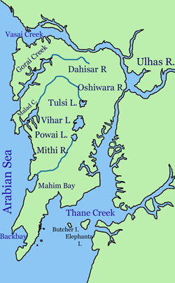
The Powai Hills are present north of the city. The Borivali National Park occupies most of the region. The Vihar and Tulsi Lakes are present within the hills. The highest point of the metropolis, at 450 metres (1,480 ft), is located in this region.

Lakes

There are three lakes in the city. The Vihar Lake and the Tulsi Lake are present within the National Park and supply part of the city's drinking water. The Powai Lake is immediately south of these two. They are located in central Mumbai.

Bays

Back Bay is the largest bay in the city. The coastline of Back Bay is an inverted C-shaped region 4 kilometres in length, and Marine Drive is located along this stretch. North of Marine Drive is Worli Bay. In the centre of the bay is the tomb of Haji Ali, a 14th-century Muslim saint. The bay perimeter is about two kilometres in length.

Mahim Bay is the second largest bay in the city. The Mithi River empties into the Mahim Creek which drains into the bay. The border between the city and its suburbs bisects the bay. To the north lies Bandra and to the south, Mahim.

Creeks

Mumbai has numerous creeks with close to 71 km2 of creeks and mangroves along its coastline. [1] The mangroves adjoin broad tidal mudflats adjacent to the city. [2] The Vasai Creek to the north and Thane Creek to the east separates Salsette Island from the mainland. Within the city the Malad (or Marve) Creek and the Gorai (or Manori) Creek inundate the suburban region. The Mahim Creek forms the border between the two districts. There are also the Mahul Creek and the Mahim Creek.

Islands

Mumbai in 1909 Bombay 1909.jpg
Mumbai in 1909

Although the islands were merged in the 18th century, islands still dot Thane Creek. Elephanta Island, Butcher Island, Oyster Rock, Cross Island and Middle Ground are scattered across the Creek. The latter three are uninhabited islets owned by the Indian Navy.

Rivers

Related Research Articles

Chembur is an upmarket large suburb in central Mumbai, India. It belongs on harbour line of suburban railways and offers the best connectivity with Mumbai Monorail, Santacruz- Chembur Link Road, Airport, Jeejamata Bhosle Marg, Eastern Freeway, Eastern Expressway, BKC connector, Mumbai Satara highway (Sion-Panvel). It doesn't takes much long to reach South Mumbai, Navi Mumbai, Airport, BKC, Powai, Thane.

<span class="mw-page-title-main">Kurla</span> Suburb in Mumbai Suburban, Maharashtra, India

Kurla is a suburb of East Mumbai, India. It is the headquarters of the Kurla taluka of Mumbai Suburban district. The neighbourhood is named after the eponymous East Indian village that it grew out of. It falls under Zone 5, Ward 'L' of the Bombay Municipal Corporation. Its railway station, spelt as Coorla until 1890, is one of the busiest on the Mumbai suburban railway on the central and harbour railway lines of Mumbai as is the Lokmanya Tilak Terminus (LTT) for out-station passenger/express trains.

<span class="mw-page-title-main">Mahim</span> Neighbourhood in Mumbai City, Maharashtra, India

Mahim (Marathi: माहिम) is a neighbourhood in Mumbai, Maharashtra, India. The Mahim Junction railway station on the Western Railway and Harbour Railway of the Mumbai Suburban Railway network is the last station of the city, as neighboring Bandra comes in Mumbai Suburb. Mahim is an ethnically and religiously diverse town and has a Hindu temple, church, mosque and Parsi fire-temple existing within a few meters of each other. The town has a large Rich and Upper Middle class Marathi population.

<span class="mw-page-title-main">Seven Islands of Bombay</span>

The Seven Islands of Bombay were 16th-century Portuguese colonial possessions lying off the Konkan region by the mid-west coast of India.

<span class="mw-page-title-main">Salsette Island</span> Island off the coast of Maharashtra, India

Salsette Island is an island in Konkan division of the state of Maharashtra, on India's west coast. Administratively known as Greater Mumbai, the city district of Mumbai, Mumbai Suburban district, Mira Bhayander, and a portion of Thane lie within it, making it very populous and one of the most densely populated islands in the world. It has a population of more 20 million inhabitants living on an area of about 619 square kilometres (239 sq mi).

<span class="mw-page-title-main">South Mumbai</span> Precinct of Mumbai in Maharashtra, India

South Mumbai, colloquially SoBo from South Bombay in Anglo-Indian English, administratively the Mumbai City District, is the city centre and the southernmost precinct of Greater Bombay. It extends from Colaba to Mahim and Sion neighbourhoods, and comprises the city's main business localities, making it the wealthiest urban precinct in India. Property prices in South Mumbai are by far the highest in India and among the highest in the world.

<span class="mw-page-title-main">Tulsi Lake</span> Lake in India

Tulsi Lake is a fresh water lake in northern Mumbai. It is stated to be the second largest lake in Mumbai and supplies part of the city's potable water. This is one of the three lakes located in the Salsette Island; the other two being Powai Lake and Vihar Lake. Both Tulsi lake and Vihar lake are located within the densely forested Sanjay Gandhi National Park or also known popularly as the Borivali National Park (BNP).

<span class="mw-page-title-main">Vihar Lake</span> Lake in Mumbai

Vihar Lake is located near Vihar village on the Mithi River within the precincts of the Borivali National Park, also called the Sanjay Gandhi National Park, in North Mumbai. When built in 1860, it was considered as the largest lake in Mumbai in the Salsette group of islands. It is hemmed between the Tulsi Lake and the Powai Lake. It partly meets the drinking water needs of the Mumbai region. It supplies only 3% of the Mumbai city's water requirement, after filtration at Bhandup where the large water filtration plant is located.

<span class="mw-page-title-main">Mumbai Harbour</span> Neighbourhood in Mumbai, Maharashtra, India

Mumbai Harbour, is a natural deep-water harbour in the southern portion of the Ulhas River estuary. The narrower, northern part of the estuary is called Thana Creek. The harbour opens to the Arabian Sea to the south. The historical island of Elephanta is one of the six islands that lie in the harbour.

<span class="mw-page-title-main">Mithi River</span> River in Mumbai, India

The Mithi River is a river on Salsette Island, the island of the city of Mumbai, India. It is a confluence of tail-water discharges of the Powai and Vihar lakes. The river is seasonal and rises during the monsoons. The overflowing lakes also contribute to the river flow, which is stopped by a dam at other times. During this season, the gutter is a favourite with anglers, who can catch large fish that have escaped from the lakes. Chattrapati Shivaji Maharaj International Airport is located right next to the section of river at Andheri (E).

<span class="mw-page-title-main">Mumbai Suburban district</span> District of Maharashtra in India

Mumbai Suburban district is the second most populous district of Maharashtra in the Konkan Division. With its administrative headquarters in Bandra, the district consists of three subdivisions or tehsils (townships): Kurla, Andheri, and Borivali. The district along with Mumbai City district and other suburban localities make up Greater Mumbai. The district occupies an area of 446 km2.

<span class="mw-page-title-main">Castella de Aguada</span> Historic fort in India

Castella de Aguada, also known as the Bandra Fort, is a fort located in Bandra, Mumbai. "Castella" is a misspelling for Portuguese "Castelo" (castle), although it seems its Portuguese builders actually called it Forte de Bandorá. It is located at Land's End in Bandra. It was built by the Portuguese in 1640 as a watchtower overlooking Mahim Bay, the Arabian Sea and the southern island of Mahim. The strategic value of the fort was enhanced in 1661 after the Portuguese ceded the seven islands of Bombay that lay to the immediate south of Bandra to the English. The name indicates its origin as a place where fresh water was available in the form of a fountain ("Aguada") for Portuguese ships cruising the coasts in the initial period of Portuguese presence. The fort lies over several levels, from sea level to an altitude of 24 metres (79 ft). Castella de Aguada has been featured in several Hindi films, such as Dil Chahta Hai and Buddha Mil Gaya.

<span class="mw-page-title-main">Mahim Bay</span> Inlet of the Arabian Sea in Mumbai

Mahim Bay is a bay, part of the Arabian Sea in Mumbai, Maharashtra, India. The southern end is Worli, northern end is Bandra Reclamation and Mahim is in the centre. The bay was named after the islands of Mahim and Salsette were merged in the early 19th century. The Mithi River drains into Mahim Creek which drains into the Bay, and forms the border between the Mumbai city and its Suburbs.

Trombay is an eastern suburb of Mumbai (Bombay), India.

Indigenous tribals have inhabited Mumbai (Bombay) since the Stone Age. The Kolis and Aagri were the earliest known settlers of the islands. The Maurya Empire gained control of the islands during the 3rd century BCE and transformed them into a centre of Hindu-Buddhist culture and religion. Later, between the 2nd century BCE and 10th century CE, the islands came under the control of successive indigenous dynasties: the Satavahanas, Abhiras, Vakatakas, Kalachuris, Konkan Mauryas, Chalukyas, Rashtrakutas, Silharas& Cholas.

<span class="mw-page-title-main">Western Suburbs (Mumbai)</span> Precinct of Greater Mumbai in Maharashtra, India

The Western Suburbs is the western precinct of the city of Mumbai, India. The Western Suburbs consist of Andheri, Bandra, Bhayander, Borivali, Dahisar, Goregaon, Jogeshwari, Juhu, Kandivali, Khar, Malad, Mira Road, Santacruz and Vile Parle. Geographically, the Western Suburbs lie at the western part of Salsette Island, is a continuous urban sprawl spanning the areas from Bandra to Bhayander, which is separated by the Vasai Creek from Vasai-Virar city and Mithi River from Mumbai city district.

<span class="mw-page-title-main">Eastern Suburbs (Mumbai)</span> Suburb in Maharashtra, India

East Mumbai consists the localities of Bhandup, Ghatkopar, Kanjurmarg, Kurla, Mulund, Nahur, Powai, Vidyavihar and Vikhroli. To the south-east lie the neighborhoods of Chembur, Govandi, Mankhurd, and Trombay.

<span class="mw-page-title-main">Vanashakti</span> Non-profit environmental organization [VANASHAKTI]

Vanashakti is a non-profit environmental NGO based in Mumbai, Maharashtra. It was formed in 2006, by Meenakshi Menon, Namita Roy Ghose, and Peter Armand Menon. Vanashakti aims to conserve the forests, wetlands, wildlife corridors, habitats, through education and litigation to achieve its objectives of creating awareness about environmental topics, protecting and reviving rivers and preventing opencast mining in areas that are well-endowed with biodiversity. It also directs its efforts in involving local forest-dwelling communities to protect the biodiversity of the region and provides sustainable livelihood options for forest dependent and coastal communities. Vanashakti's thrust areas are forest, mangrove and wetland protection, environmental education for both urban and rural schools, livelihoods for forest based communities and scientific investigation into local environmental degradation.

References

  1. Tatke, Sukhada (7 April 2012). "Mumbai for Me: Mangrove makeovers could save greenery". The Times of India . Retrieved 7 April 2012.
  2. Murray, N.J.; Clemens, R.S.; Phinn, S.R.; Possingham, H.P.; Fuller, R.A. (2014). "Tracking the rapid loss of tidal wetlands in the Yellow Sea" (PDF). Frontiers in Ecology and the Environment. 12 (5): 267–272. doi:10.1890/130260.