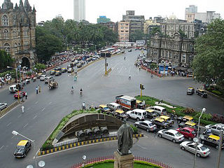
Transport in Mumbai is achieved by both public and private transport. As of 2016, 52% of commuters use public transport. Mumbai has the largest organized bus transport network among major Indian cities.

Bandra ([bæːɳɖɾa]) is a coastal suburb located in Mumbai, the largest city of the Konkan division in Maharashtra, India. The area is located to the immediate north of the River Mithi, which separates Bandra from the Mumbai City district. It is the third-largest commercial hub in Maharashtra, after the Mumbai City and Pune, primarily aided by the Bandra Kurla Complex.

Santacruz or Santa Cruz is a suburb of Mumbai. The Santacruz railway station on the Mumbai Suburban Railway, the domestic terminal (T1) of the Chhatrapati Shivaji Maharaj International Airport, and one campus of the University of Mumbai, are all located in Santacruz (East).

Mahim (Marathi: माहिम) is a neighbourhood in Mumbai, Maharashtra, India. The Mahim Junction railway station on the Western Railway and Harbour Railway of the Mumbai Suburban Railway network is the last station of the city, as neighboring Bandra comes in Mumbai Suburb. Mahim is an ethnically and religiously diverse town and has a Hindu temple, church, mosque and Parsi fire-temple existing within a few meters of each other. The town has a large Rich and Upper Middle class Marathi population.

Juhu is a suburb of Mumbai. It is known for the sprawling Juhu Beach. It is surrounded by the Arabian Sea to the west, Versova to the north, Vile Parle to the east and Santacruz to the south. Juhu is among the most expensive and affluent areas of the metropolitan area and home to many Bollywood celebrities. The nearest railway stations are Santacruz, Andheri and Vile Parle on the Western Line and Harbour Line of the Mumbai Suburban Railway. The nearest metro stations are D. N. Nagar and Andheri West. There are two minor B.E.S.T bus depots in Juhu.

Salsette Island is an island in Konkan division of the state of Maharashtra, along India's west coast. Administratively known as Greater Mumbai, the Mumbai Suburban district, Mira Bhayander and a portion of Thane district lie within it, making it very populous and one of the most densely populated islands in the world. It has a population of more than 20 million inhabitants living on an area of about 619 square kilometres (239 sq mi).

South Mumbai, colloquially SoBo from South Bombay in Indian English, administratively the Mumbai City District, is the city centre and the southernmost precinct of Greater Bombay. It extends from Colaba to Mahalaxmi, Byculla and Mazgaon neighbourhoods, and comprises the city's old and formerly main business localities, making it the wealthiest urban precinct in India. Property prices in South Mumbai are by far the highest in India and among the highest in the world. In terms of Maharashtra Legislative Assembly, the precinct consists of the constituencies of Colaba, Mumbadevi, Malabar Hill and Byculla.

Juhu Aerodrome is located in Juhu, an upmarket residential suburb of Mumbai, Maharashtra, India. It is served primarliy by general aviation aircraft and helicopters. It was founded in 1928 as India's first civil aviation airport.
The Western Freeway was a proposed controlled-access highway in Mumbai, India that would stretch from Marine Drive in South Mumbai to Kandivli in the north, a distance of 29 km. The project envisioned the construction of four major sea links over the Arabian Sea along Mumbai's western coastline to reduce traffic-congestion between the Western Suburbs and South Mumbai.

Khar is an affluent suburb of Mumbai, north of Bandra and south of Santacruz, Mumbai. Originally one of the 'villages' that made up the larger Bandra, the present suburb is divided into Khar West and Khar East areas. It is serviced by Khar Road railway station of the Mumbai Suburban Railway network. It is an area within convenient distances of several schools, restaurants, parks, promenades and shopping centres. Khar bears the Mumbai Postal Index Number 400052.

Mahim Bay is a picturesque bay situated in the Arabian Sea, along the western coast of India. It is located in the southern part of Mumbai, the capital city of the Indian state of Maharashtra. The bay was named after the islands of Mahim and Salsette were merged in the early 19th century. The Mithi River drains into Mahim Creek which drains into the Bay, and forms the border between the Mumbai city and its Suburbs.

Santacruz is the name of a railway station on the Mumbai suburban railway on the Western Line and Harbour Line. The station began operations in October 1888. The neighborhood is Santacruz.

The Santa Cruz–Chembur Link Road, shortened to SCLR, is a 6.45-kilometre-long (4.01 mi) arterial road in Mumbai, connecting the Western Express Highway (WEH) in Santa Cruz with the Eastern Express Highway (EEH) in Chembur. It contains the city's first and India's second double-decker flyover. The six-lane road was constructed as part of the World Bank-funded Mumbai Urban Transport Project (MUTP) at a cost of ₹454 crore (US$54 million). The World Bank withdrew funding midway through the project due to repeated delays, and the second phase was financed by the Mumbai Metropolitan Region Development Authority (MMRDA) with its own funds.
The Western Railway Elevated Corridor, also known as the Oval Maidan-Virar elevated corridor, was a proposed rapid transit corridor that would have run along the same alignment as the Western Line of the Mumbai Suburban Railway, and link Oval Maidan with Virar.

The Western Suburbs is the western precinct of the city of Mumbai, India. The Western Suburbs consist of Andheri, Bandra, Marol, Oshiwara Lokhandwala, Borivali, Dahisar, Goregaon, Versova, Jogeshwari, Juhu, Kandivali, Khar, Malad, Sakinaka, Santacruz and Vile Parle. Geographically, the Western Suburbs lie at the western part of Salsette Island, is a continuous urban sprawl spanning the areas from Bandra to Bhayander, which is separated by the Vasai Creek from Vasai-Virar city and Mithi River from Mumbai city district.
Maharashtra is a state in western India. It is the country's second-most-populous state and third-largest state by area. Maharashtra is bordered by the Arabian Sea on the west, Gujarat and the Union territory of Dadra and Nagar Haveli on the northwest, Madhya Pradesh on the north and northeast, Chhattisgarh on the east, Karnataka on the south, Telangana on the southeast and Goa on the southwest. The state covers 307,731 km2 (118,816 sq mi), or 9.84 percent of India's total area.
The Versova–Bandra Sea Link (VBSL), officially Swatantrya Veer Savarkar Sea Link, is an under-construction bridge in Mumbai, Maharashtra, India as a part of Coastal Road Phase-3 or Western Coastal Road. The 17.17-kilometre (10.67 mi) bridge will connect Versova, a neighbourhood in the suburb of Andheri to the Bandra–Worli Sea Link in Bandra, as part of the Coastal Road. The 8-lane sea link is expected to reduce congestion on the Western Express Highway and the Western Line of the Mumbai Suburban Railway.


