Timeline of Mumbai

Last updated

The history of Mumbai can be traced back to 600 BC, with evidence of the first known settlement of the Harrappan civilization discovered in the region.[ citation needed ]

Contents

up to 18th century

19th century

Mumbai in 1888 Situationsplan von Bombay (Mumbai).jpg
Mumbai in 1888
Mumbai ca. 1890 BOMBAY C 1890.jpg
Mumbai ca. 1890

20th century

21st century

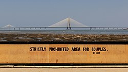
Bandra-Worli Sea Link Mumbai 03-2016 82 Dadar Beach view of the SeaLink.jpg
Bandra-Worli Sea Link

See also

Related Research Articles

<span class="mw-page-title-main">Transport in Mumbai</span> Different types of public transport in Mumbai

Transport in Mumbai is achieved by both public, and private transport. As of 2015, 52% of commuters use public transport. Mumbai has the largest organized bus transport network among major Indian cities.

<span class="mw-page-title-main">Mumbai Suburban Railway</span> Set of railway lines in India

The Mumbai Suburban Railway consists of exclusive inner suburban railway lines augmented by commuter rail on main lines serving outlying suburbs to serve the Mumbai Metropolitan Region. Spread over 390 kilometres (240 mi), the suburban railway operates 2,342 train services and carries more than 7.5 million commuters daily.

<span class="mw-page-title-main">Dadar</span> Neighbourhood in Mumbai City, Maharashtra, India

Dadar ([d̪aːd̪əɾ]) is a densely populated residential and shopping neighbourhood in Mumbai. It is also a prominent railway and bus service hub with local and national connectivity. Dadar holds the distinction of being Mumbai’s first planned area and it is also a hub for the city's Marathi culture. It includes the Dadar West area.

Matunga is a locality in the heart of Mumbai City towards downtown Mumbai. It is serviced by the Matunga Road station on the Western line, Matunga station on the Central Line and King's Circle station on the Harbour Line.

<span class="mw-page-title-main">Kurla</span> Suburb in Mumbai Suburban, Maharashtra, India

Kurla is a suburb of East Mumbai, India. It is the headquarters of the Kurla taluka of Mumbai Suburban district. The neighbourhood is named after the eponymous East Indian village that it grew out of. It falls under Zone 5, Ward 'L' of the Bombay Municipal Corporation. Its railway station, spelt as Coorla until 1890, is one of the busiest on the Mumbai suburban railway on the central and harbour railway lines of Mumbai as is the Lokmanya Tilak Terminus (LTT) for out-station passenger/express trains.

<span class="mw-page-title-main">Mahim</span> Neighbourhood in Mumbai City, Maharashtra, India

Mahim (Marathi: माहिम) is a neighbourhood in Mumbai, Maharashtra, India. The Mahim Junction railway station on the Western Railway and Harbour Railway of the Mumbai Suburban Railway network is the last station of the city, as neighboring Bandra comes in Mumbai Suburb. Mahim is an ethnically and religiously diverse town and has a Hindu temple, church, mosque and Parsi fire-temple existing within a few meters of each other. The town has a large Rich and Upper Middle class Marathi population.

<span class="mw-page-title-main">Salsette Island</span> Island off the coast of Maharashtra, India

Salsette Island is an island in Konkan division of the state of Maharashtra, on India's west coast. Administratively known as Greater Mumbai, the city district of Mumbai, Mumbai Suburban district, Mira Bhayander, and a portion of Thane lie within it, making it very populous and one of the most densely populated islands in the world. It has a population of more than 20 million inhabitants living on an area of about 619 square kilometres (239 sq mi).

<span class="mw-page-title-main">Jamsetjee Jejeebhoy</span> Indian baronet

Sir Jamsetjee Jejeebhoy, 1st Baronet Jejeebhoy of Bombay, also spelt Jeejeebhoy or Jeejebhoy, was an Indian-Parsi merchant and philanthropist, later a British knight and baronet. He made a huge fortune in cotton and the opium trade with China.

<span class="mw-page-title-main">Geography of Mumbai</span> Overview of Mumbais geography

Mumbai (Bombay) is India's most populous city with a population of 20 Million. It is located on Salsette Island off the coast of Maharashtra. The original Seven Islands of Bombay were merged by the British in the 18th century, to form one large island.

Lovji Nusserwanjee Wadia (1702–1774) was a Parsi from Surat province of Gujarat in India and was a member of the Wadia family of shipwrights and naval architects, who founded Wadia Group in 1736.

Indigenous tribals have inhabited Mumbai (Bombay) since the Stone Age. The Kolis and Aagri were the earliest known settlers of the islands. The Maurya Empire gained control of the islands during the 3rd century BCE and transformed them into a centre of Hindu-Buddhist culture and religion. Later, between the 2nd century BCE and 10th century CE, the islands came under the control of successive indigenous dynasties: the Satavahanas, Abhiras, Vakatakas, Kalachuris, Konkan Mauryas, Chalukyas, Rashtrakutas, Silharas& Chollas.

<span class="mw-page-title-main">Dadar Parsi Colony</span> Neighbourhood in Mumbai City, Maharashtra, India

Dadar Parsi Colony is an upper class Parsi colony in midtown South Mumbai. It is situated in the locality of Dadar-Matunga. Unlike the other Parsi colonies it is not surrounded by a wall or fence and is not isolated from its surroundings. The colony houses the famous Five Gardens created by Mancherji Joshi, a renowned Parsi.

<span class="mw-page-title-main">History of Bombay under British rule (1661–1947)</span>

Bombay, also called Bom baim in Portuguese, is the financial and commercial capital of India and one of the most populous cities in the world.

Mumbai, also known as Bombay, is the financial capital of India and one of the most populous cities in the world. Mumbai grew into a leading commercial center of India during the 19th century on the basis of textile mills and overseas trade. After independence, the desire to domesticate a Marathi social and linguistic Mumbai to a cosmopolitan framework was strongly expressed in the 1950s. Mumbai, one of the earliest cities in India to be industrialized, emerged as the centre of strong organized labour movement in India, which inspired labour movements across India.

The history of Mumbai during the 21st century covers the Indian city of Mumbai in the 21st century, during which the city suffered several terrorist attacks.

<span class="mw-page-title-main">Churchgate railway station</span> Railway Station in Maharashtra, India

Churchgate is the southern terminus on the Western Line of the Mumbai Suburban Railway. It is located in Churchgate in South Mumbai, Maharashtra.

The Western line of the Mumbai Suburban Railway is a public transit system serving Mumbai Metropolitan Region, Maharashtra. It consists of 37 stations from Dahanu Road to Churchgate railway station. It is operated by Western Railways (WR). The entire line is at grade.

<span class="mw-page-title-main">Bandra railway station</span> Railway Station in Maharashtra, India

Bandra is a railway station on the Western Line and Harbour Line of the Mumbai Suburban Railway network. It serves the Bandra suburban area and the commercial area of Bandra-Kurla Complex (BKC). Bandra Terminus is near to Bandra railway station and serves interstate traffic on the Western Railway.

<span class="mw-page-title-main">Western Suburbs (Mumbai)</span> Precinct of Greater Mumbai in Maharashtra, India

The Western Suburbs is the western precinct of the city of Mumbai, India. The Western Suburbs consist of Andheri, Bandra, Bhayander, Borivali, Dahisar, Goregaon, Jogeshwari, Juhu, Kandivali, Khar, Malad, Mira Road, Santacruz and Vile Parle. Geographically, the Western Suburbs lie at the western part of Salsette Island, is a continuous urban sprawl spanning the areas from Bandra to Bhayander, which is separated by the Vasai Creek from Vasai-Virar city and Mithi River from Mumbai city district.

Kherwadi is a middle class, developing neighborhood, situated on the eastern side of Bandra railway station, Mumbai. Its name is derived from the first chief minister of Bombay State, B. G. Kher. It is surrounded by the CBD of BKC to the east, Mahim to the south, Khar to the north and S.V. Road to the west. It is well connected to all the parts of Mumbai, Navi Mumbai and Thane. Western Expressway passes through Kherwadi junction, a signal intersection situated in Kherwadi.

References

  1. http://nirc.nanzan-u.ac.jp/nfile/1064 [ bare URL PDF ]
  2. Schellinger and Salkin, ed. (1996). "mumbai". International Dictionary of Historic Places: Asia and Oceania. UK: Routledge. ISBN   9781884964046.
  3. "I.E.S. Raja Shivaji Vidyalaya". www.iesrsv.com. Retrieved 12 December 2016.
  4. Ṭikekara, Aruṇa (2006). The Cloister's Pale: A Biography of the University of Mumbai. Popular Prakashan. p. 198. ISBN   978-81-7991-293-5 . Retrieved 12 June 2020.
  5. James C. Docherty; Peter Lamb (2006). "Chronology". Historical Dictionary of Socialism (2nd ed.). Scarecrow Press. ISBN   978-0-8108-6477-1.
  6. "South Asia and the Himalayan Region, 1900 A.D.–present: Key Events". Heilbrunn Timeline of Art History. New York: Metropolitan Museum of Art . Retrieved 26 August 2021.
  7. "Corporate Information: Google Offices". Google Inc. Archived from the original on 31 August 2006.