Related Research Articles

Thane is a metropolitan city located on the northwestern side of the state of Maharashtra in India. It is an immediate neighbour of Mumbai city proper, and a part of the Mumbai Metropolitan Region. It is situated in the north-eastern portion of the Salsette Island.
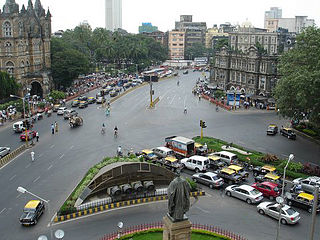
Transport in Mumbai is achieved by both public, and private transport. As of 2015, 52% of commuters use public transport. Mumbai has the largest organized bus transport network among major Indian cities.

Maharastra State Highway 42, commonly referred to as Ghodbunder Road or G.B. Road, runs entirely through the district of Thane. It is one of the major roads leading out of Thane city and connects to the Eastern Express Highway coming from south at Kapurbawdi, which later becomes National Highway 3 at this junction travels North-East. It also connects to the Western Express Highway coming from south at Ghodbunder village, which later becomes National Highway 8 at this junction traveling North-ward's towards Gujarat.

Thane Creek is an inlet in the shoreline of the Arabian Sea that isolates the city of Mumbai from the Konkan region of the Indian mainland. It comprises the area between Mumbra Retibunder and the Mankhurd-Vashi Bridge. The creek is divided into two parts. The first part lies between Ghodbunder and Thane (Thana), a section from where the Ulhas river flows from the north of Mumbai Island to meet the Arabian Sea on the west. The second part of the waterway lies between the city of Thane and the Arabian Sea at Trombay / Uran, before the Gharapuri islands.
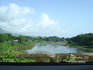
The Ulhas River is a river in Maharashtra, India. It is in the Thane, Raigad, and Pune districts of that state. It flows north and west from it source to where it splits into Vasai Creek and Thane Creek, near Thane. The Ulhas divides Salsette Island from the mainland, and is important for the water supply of Mumbai.
Mumbai is the entertainment, fashion and commercial centre of India. Mumbai is the largest economy in India. As of 2021, Mumbai Metro's nominal GDP is estimated to be US$277.980 billion and GDP (PPP) is estimated to be US$606.625 billion, Mumbai's GDP (PPP) per capita rounds up to around US$23,000. It is the richest Indian city and 12th richest city in the world with a net wealth of around US$1 trillion with 46,000 millionaires and 48 billionaires. Mumbai accounts for slightly more than 6.16% of India's economy, contributing 10% of factory employment, 30% of income tax collections, 45% of entertainment tax, 60% of customs duty collections, 20% of central excise tax collections, 40% of foreign trade, 100% of stock market assets and rupees 1,60,000 crore in corporate taxes to the Indian economy.

The Vashi Bridge, also known as Thane Creek Bridge or the Second Thane Creek Bridge, is a road bridge completed in the late 1990s across Thane Creek, which connects the city of Mumbai to the Indian mainland at Navi Mumbai. The bridge links the suburb of Mankhurd in Mumbai with Vashi in Navi Mumbai, the satellite city of Mumbai. It is one of four entry points into Mumbai, and handles traffic directed towards the region to the south and east of Mumbai.

Mumbai Metropolitan Region, is a metropolitan area consisting of Mumbai and its satellite towns in the northern Konkan division of Maharashtra in western India. The region has an area of 6,328 square kilometres (2,443 sq mi) and with a population of over 26 million it is among the most populous metropolitan areas in the world.
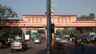
Kalwa is a city situated near Thane in Thane district, in the State of Maharashtra, India. The nearest railway station is the Kalwa railway station on the Central Line of the Mumbai Suburban Railway. Previously, Kalwa railway station had 2 platforms but now it has increased to 4.
Raigad district, previously Colaba district, is a district in the Konkan division of Maharashtra, India.

Expressways are the highest class of roads in India. As of July 2023, India has a total length of 4,901 km (3,045 mi) of expressways. These are controlled-access highways where entrance and exits are controlled by the use of cloverleaf or trumpet or grade separated interchanges that are incorporated into the design of the expressway and designed for maximum speed of 120 km/h, whereas National highways are flyover access or tolled, where entrance and exit is through the side of the flyover, at each intersection of highway with road, flyovers are provided to bypass the city/town/village traffic and these highways are designed for speed of 100 km/h. Some roads are not access-controlled expressways, but are still named as expressways, such as the Biju Expressway, these are actually state highways which are not declared by central government as an Expressway, hence not an Expressway or National Highway. Mumbai–Pune Expressway is the first 6-lane operational expressway in India started in 2002. Expressways follow standards set by Indian Roads Congress and Bureau of Indian Standards.
The Sion Panvel Expressway is a 25 km Indian highway located entirely in the state of Maharashtra, that connects Sion in Mumbai with Panvel, via Navi Mumbai. It is one of the busiest and most important roads in the Mumbai Metropolitan Region (MMR) and connects Mumbai with the city of Pune. The National Highway 4 and Mumbai-Pune Expressway begin at the eastern end of the expressway, at Kalamboli junction, near Panvel. The highway is also used by vehicles traveling towards Mumbai from Konkan and Goa.
Lal Bahadur Shastri Marg, commonly known by its abbreviation LBS Marg, is a 21 km long, major arterial road connecting the neighbouring city of Thane with Sion in Mumbai. It passes through heavily populated areas of the Eastern Suburbs in Mumbai and is heavily congested. Approximately, 3 lakh vehicles use this road daily. The road is named after Lal Bahadur Shastri, the second Prime Minister of India.
Digha is a small township near Airoli in Navi Mumbai, India.

Shrikant Eknath Shinde is a member of the 17th Lok Sabha of India. He represents the Kalyan constituency of Maharashtra and is a member of the Shiv Sena political party.
Thane–Belapur Road is a major road connecting the city of Thane with Navi Mumbai. The southern end of Thane–Belapur Road starts at the Sion Panvel Highway near Juinagar. The road passes through a busy Thane – Belapur region and generally runs in a north-south direction. During the stretch between Turbhe and Digha, the Thane–Belapur Road runs completely parallel to the Trans-Harbour Line of Mumbai Suburban Railway and the stations of Airoli, Rabale, Ghansoli, Kopar Khairane and Turbhe all have direct access from this road. This road also connects the cities of Thane, Kalwa, and Airoli to the Mumbai-Pune Expressway.

The Vikhroli-Kopar Khairane Link Road (VKLR), also known as the JVLR-Kopar Khairane-Ghansoli Bridge, is a proposed 7.5 km to 10 km, freeway grade road bridge connecting the Indian city of Mumbai with Navi Mumbai, its satellite city. The new link road would start at Eastern Express Highway (EEH) where Jogeshwari–Vikhroli Link Road (JVLR) ends in Vikhroli, then cross Thane Creek and Harbour railway line and will terminate at Kopar Khairane in Navi Mumbai before ending on Thane-Belapur Road. The link would be a six-lane road of about 10 km in length including a 2-kilometre-long (1.2 mi) bridge over the Thane Creek. At present motorists have to take either the Vashi Bridge or Mulund-Airoli Link Road to go to Navi Mumbai and Pune. The new road will help motorists save time and fuel. The project is estimated to cost around ₹ 550 to 1200 crore. Mumbai Metropolitan Region Development Authority (MMRDA) appointed N P Bridging, as designing consultants for the project, which was supposed to submit the final report on the link road by mid-September 2016.

Orange Line 5, or the Thane-Bhiwandi-Kalyan Line, is a rapid transit line in the Mumbai Metropolitan Region, Maharashtra, India, and part of the Mumbai Metro system. When fully completed, the 24.9 km (15.5 mi) line will connect Thane with Kalyan via Bhiwandi, with 17 stations. The line will be fully elevated except for a 3 km underground section in Bhiwandi.
The Samruddhi Mahamarg or Nagpur-Mumbai Expressway and Maharashtra Expressway-2 (ME-2), is a partially opened 6-lane wide, 701-km long access-controlled expressway in Maharashtra, India. It is amongst the country's longest greenfield road projects, which will connect the two capital cities of the state, its capital, Mumbai, and its third-largest and vice-capital city, Nagpur. The project is being led by the state infrastructure arm Maharashtra State Road Development Corporation (MSRDC), and is designed under the Engineering, Procurement and Construction (EPC) model.
References
- ↑ "After Mahad tragedy, authorities shut down 153-year-old bridge in Thane". Hindustan Times. 4 August 2016. Retrieved 26 January 2022.
- ↑ Badgeri, Manoj. "Kalwa bridge shut for structural audit". The Times of India. Retrieved 26 January 2022.
- ↑ "Thane police shut 153-year-old Kalwa bridge". DNA India. Retrieved 26 January 2022.
- ↑ "Mahad bridge tragedy: Now, 153-year-old Kalwa bridge in Thane shut down by authorities". Firstpost. 5 August 2016. Retrieved 26 January 2022.
- 1 2 "Maha govt committed to ending traffic woes in Thane: CM Shinde". Hindustan Times. 14 November 2022. Retrieved 4 December 2022.
- ↑ "'3rd Kalwa Bridge Fully Operational By March Next Yr'". The Times of India. Thane News. 21 October 2022. Retrieved 4 December 2022.
- ↑ "Good news! First phase of Thane-Kalwa creek bridge to be operational by August end". Free Press Journal. Retrieved 4 December 2022.
- ↑ Badgeri, Manoj. "Thane: Third Kalwa creek bridge to operate by year-end". The Times of India. Retrieved 26 January 2022.
- ↑ "Thane: Lane of new Kalwa bridge to open for traffic on Nov 30". Mid-day. 29 November 2022. Retrieved 4 December 2022.
- ↑ "Thane: 4th lane on new Kalwa Bridge opened for traffic from November 30". Free Press Journal. Retrieved 4 December 2022.
- ↑ "New Lane on Kalwa Bridge for Navi Mumbai Route". Mumbai Live. 10 March 2023. Retrieved 20 May 2023.