Line 10 (Mumbai Metro)

Last updated

MMRDA Logo.jpg Mumbai Metro Green Line 10 Extension
Maha Mumbai Metro.png
Overview
Other name(s)Versova To Shivaji Chowk (Mira Road)
StatusApproved
Owner MMRDA
Line numberMetro Line 10
Locale Western Suburbs
Termini
  • Gaimukh (Thane)
  • Shivaji Chowk (Mira Road)
Stations4
Service
Type Rapid Transit
System Mumbai Metro
Operator(s) Mumbai Metro
Depot(s)Owale & Gaimukh
Daily ridership2024 0.8 million 2031 1.2 million
History
Planned opening2024;0 years ago (2024)
Technical
Line length9.2 km (5.7 mi)
Number of tracks2
CharacterElevated
Track gauge 1,435 mm (4 ft 8+12 in) standard gauge
Operating speed90 km/h (56 mph)
Highest elevation3.90 m (12.8 ft)
Route map

Contents

Line 10
BSicon uexhCONTg.svg
to BSicon exSUBWAY-CHN.svg Line 9
BSicon uexhINTACCl.svg
BSicon HUBa.svg
BSicon uexhCONTfq.svg
Amar Palace (Miragaon) on BSicon exSUBWAY-CHN.svg Line 9
BSicon uexhKINTACCa.svg
BSicon HUBe.svg
0.0000
Shivaji Chowk (Mira Road)
BSicon uexhACC.svg
0.8729
Kashimira
BSicon uexhACC.svg
3.5575
Varsova Char Phata
BSicon RP4e.svg
BSicon uexhSKRZ-G4.svg
BSicon dRP4q.svg
BSicon uexhACC.svg
7.8998
Gaimukh Reti Bandar
BSicon uexhACC.svg
9.3709
Gaimukh
BSicon uexhABZgl.svg
BSicon uexKDSTeq.svg
BSicon lhSTRe@gq.svg
Mogharpada Depot
BSicon uexhCONTf.svg
to Line 4

Green Line 10 (extension) of the Mumbai Metro, also referred to as the Gaimukh-Shivaji Chowk (Mira Road) corridor, is part of the metro system for the city of Mumbai, India. This line is fully elevated.

In February 2017, the MMRDA announced that the DMRC was preparing a detailed project report (DPR) on Metro 10. Preliminary plans were prepared jointly by MMRDA and DMRC. The line will run parallel to Thane - Bhayandar Highway, and will join metro route no 9 at Chhatrapati Shivaji Maharaj Chowk. The project is estimated to cost ₹3,600 crore (US$530 million). [1] [2] [3]

Prime Minister Narendra Modi in Mumbai on September 7 laid the foundation stone of Mumbai Metro Lines 10 the 9.2 km (5.7 mi) long Gaimukh to Shivaji Chowk (Mira Road) Metro-10.It is expected to be completed in 2030 and is expected to provide interconnectivity among Mira-Bhayander, Thane, Borivali and rest of Mumbai. It will reduce the current travel time by between 50% and 75% depending on road conditions.

Planning

The proposed Metro Rail at Mumbai has one corridor covering an approximate distance of about 9.209 km (5.722 mi). The corridor will have four stations, all elevated. Some sections of the corridor are underground. Almost all the stations are on the road stations.

The stations have been located so as to serve passenger requirements and to enable convenient integration with other modes of transport. Efforts have been made to propose station locations at a uniform inter-station distance as feasible. The average inter-station distance is ≈2 km, though it varies from 0.873 km to 4.34 km due to land-use and topographic reasons. The minimum inter-station distance is between Shivaji Chowk (Mira Road) Station and Kashimira Metro Station i.e. 872.941 m. The maximum inter-station distance is between Gaimukh Reti Bundar and Varsova Char Phata i.e. 4342.345 m.

Station Type

The stations have been planned with side platforms to avoid the viaduct structure from flaring in and out at stations, which obstructs the road traffic below. Care has been taken to locate stations in straight alignment. However, in some stations, site constraints have become the deciding criteria and a curve of 1000m radius has been introduced in the platform.

List of stations

Mumbai Metro line 10 Map Metro line 10 map whole.jpg
Mumbai Metro line 10 Map
#Station NameInter-station Distance (m)Type of the station
1Gaimukh Reti Bundar0Elevated
2Varsova Char Phata4342.34Elevated
3Kashimira2684.64Elevated
4Shivaji Chowk (Mira Road)872.941Elevated

Mumbai Metro Line 4 with Line 10 and Line 11 Extension plan:-

List of stations of Line-11 & Line-4 (CSMT to Gaimukh) and Line-10 (Gaimukh to Shivaji Chowk (Mira Road)) which is the extension of Mumbai Metro is given below: -

S. No.Name of StationStation TypeConnections
1Shivaji Chowk (Mira Road)Elevated Line 9 (Mumbai Metro)
2KashimiraElevatedNone
3Varsova Char PhataElevatedNone
4Gaimukh Reti BunderElevatedNone
5GaimukhElevated Line 4A (Mumbai Metro)
6GowniwadaElevatedNone
7KasarvadavaliElevated Line 4 (Mumbai Metro)
8Vijay GardenElevatedNone
9DongripadaElevatedNone
10Tikuji-ni-wadiElevatedNone
11ManpadaElevatedNone
12KapurbawdiElevated Line 5 (Mumbai Metro)
13MajiwadaElevatedNone
14Cadbury JunctionElevatedNone
15Mahapalika MargElevatedNone
16RTO ThaneElevatedNone
17Teen Haath Naka (Thane)ElevatedNone
18Mulund NakaElevatedNone
19Mulund Fire StationElevatedNone
20SonapurElevatedNone
21ShangrilaElevatedNone
22BhandupElevatedNone
23Bhandup MahapalikaElevatedNone
24Naval HousingElevatedNone
25Gandhi Nagar (Kanjurmarg)Elevated Line 6 (Mumbai Metro)
26Surya NagarElevatedNone
27VikhroliElevatedNone
28Godrej CompanyElevatedNone
29Shreyas CinemaElevatedNone
30Laxmi NagarElevatedNone
31Pant NagarElevatedNone
32Garodia NagarElevatedNone
33Amar Mahal JunctionElevated Line 2 (Mumbai Metro)
34Siddharth ColonyElevatedNone
35Suman NagarElevatedNone
36Anik Nagar Bus DepotElevatedNone
37Wadala Truck TerminalElevatedNone
38Bhakti Park (Wadala)Elevated Line 1 (Mumbai Monorail) & Line 11 (Mumbai Metro)
39Ganesh NagarElevatedNone
40BPT HospitalElevatedNone
41SewriUndergroundNone
42Hay BunderUndergroundNone
43Coal BunderUndergroundNone
44DarukhanaUndergroundNone
45Wadi TowerUndergroundNone
46Clock TowerUndergroundNone
47Carnac BunderUndergroundNone
48Chhatrapati Shivaji Maharaj TerminusUnderground Line 3 (Mumbai Metro)

The car depot will be located at either at Owale or Gaimukh shall be used for this extension of Metro Line 10, Line 11 and Line 4.

Stations

Line 10 connects Gaimukh in Thane to Shivaji Chowk in Mira road. The line covers four stations in 9.2 kilometers and will run on elevated stations. The stations on this line include

Metro line 10 Map Metro line 10 Map.jpg
Metro line 10 Map
Green Line 10
#Station NameStatusConnectionsLayout
English Marathi
1 Shivaji Chowk (Mira Road) शिवाजी चौक (मिरा रोड)Approved Line 9 (Under Construction)Elevated
2 Kashimira काशिमिराApprovedNoneElevated
3 Varsova Char Phata वर्सोवा चार फाटाApprovedNoneElevated
4 Gaimukh Reti Bandar गायमुख रेती बंदरApprovedNoneElevated
5 Gaimukh गायमुखApproved Line 4 (Under Construction)Elevated

This line is expected to cost Rs. 4,476 crore. This line will also connect Borivali, Mira-Bhayander, Thane, and rest of Mumbai.

Related Research Articles

<span class="mw-page-title-main">Thane</span> City in Maharashtra, India

Thane is a metropolitan city located on the northwestern side of the state of Maharashtra in India. It is an immediate neighbour of Mumbai city proper, and a part of the Mumbai Metropolitan Region. It is situated in the north-eastern portion of the Salsette Island.

<span class="mw-page-title-main">Transport in Mumbai</span> Different types of public transport in Mumbai

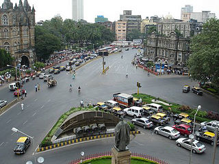
Transport in Mumbai is achieved by both public, and private transport. As of 2015, 52% of commuters use public transport. Mumbai has the largest organized bus transport network among major Indian cities.

<span class="mw-page-title-main">Mumbai Metro</span> Rapid transit system in Mumbai, India

The Mumbai Metro is a rapid transit (MRT) system serving the city of Mumbai and the wider Mumbai Metropolitan Region in Maharashtra, India.

Mira Road is a suburb north of Mumbai in Thane District and is also a part of the Mumbai Metropolitan Region. It falls within the Police Jurisdiction of Mira-Bhayander, Vasai-Virar Police Commissionerate. Mira Road is situated in the north-western portion of Salsette Island, Maharashtra state, India. Mira Road has a large Gujarati population followed by Marathis along with other ethnic groups.

<span class="mw-page-title-main">State Highway 42 (Maharashtra)</span> Road in Maharashtra, India

Maharastra State Highway 42, commonly referred to as Ghodbunder Road or G.B. Road, runs entirely through the district of Thane. It is one of the major roads leading out of Thane city and connects to the Eastern Express Highway coming from south at Kapurbawdi, which later becomes National Highway 3 at this junction travels North-East. It also connects to the Western Express Highway coming from south at Ghodbunder village, which later becomes National Highway 8 at this junction traveling North-ward's towards Gujarat.

The Mumbai Urban Transport Project (MUTP), is a project formulated by the Mumbai Metropolitan Region Development Authority (MMRDA) to bring about improvement in the traffic and transport situation in the Mumbai metropolitan region with the assistance of the World Bank.

<span class="mw-page-title-main">Western Express Highway</span> Motorway in Mumbai

The Western Express Highway, abbreviated to WEH, is a major north–south 8-10 lane arterial road in Mumbai, India, stretching from the suburb of Mira Road to Bandra. The 25.33 km (15.74 mi) highway begins near the Mahim Creek and extends to the Kashimira in the northern limit of the city till it connects National Highway 48 at Ghodbunder village. The road connects the city of Mumbai to its suburbs, including the Chhatrapati Shivaji Maharaj International Airport.

<span class="mw-page-title-main">Pune Metro</span> Rapid transit in Pune

Pune Metro is a mass rapid transit system serving the city of Pune, India. The system comprises 3 lines with a combined length of 54.14 km (33.64 mi), of which 21.75 km (13.51 mi) on two lines are operational as of August 2023. The 16.59 km (10.31 mi) Purple Line from PCMC Bhavan to Swargate runs on an elevated viaduct between PCMC Bhavan to Range Hills, from where it goes underground. The Aqua Line runs from Vanaz to Ramwadi covering a distance of 14.66 km (9.11 mi) on an elevated viaduct. The 23.33 km (14.50 mi) elevated Line 3 will run from the Rajiv Gandhi Infotech Park in Hinjawadi via Balewadi to Civil Court. All three lines will align at the Civil Court interchange station.

The Western Railway Elevated Corridor, also known as the Oval Maidan-Virar elevated corridor, was a proposed rapid transit corridor that would have run along the same alignment as the Western Line of the Mumbai Suburban Railway, and link Oval Maidan with Virar.

Ludhiana Metro was a proposed rapid transit system for the city of Ludhiana, Punjab. It is expected to cost 10,516 crore.

<span class="mw-page-title-main">Andheri railway station</span> Railway station in Maharashtra, India

Andheri is a passenger rail station located at Andheri suburb of Mumbai. It serves the Western line and Harbour lines of the Mumbai Suburban Railway. It is also a stop for some express trains and August Kranti Rajdhani Express. The station also inter-connects the Line 1 of the Andheri metro station. Andheri station first came under prominence after the development of Salsette–Trombay Railway services in 1928 by the British Empire of India during the pre-independence period.

<span class="mw-page-title-main">Western Suburbs (Mumbai)</span> Precinct of Greater Mumbai in Maharashtra, India

The Western Suburbs is the western precinct of the city of Mumbai, India. The Western Suburbs consist of Andheri, Bandra, Bhayander, Borivali, Dahisar, Goregaon, Jogeshwari, Juhu, Kandivali, Khar, Malad, Mira Road, Santacruz and Vile Parle. Geographically, the Western Suburbs lie at the western part of Salsette Island, is a continuous urban sprawl spanning the areas from Bandra to Bhayander, which is separated by the Vasai Creek from Vasai-Virar city and Mithi River from Mumbai city district.

<span class="mw-page-title-main">Line 2 (Mumbai Metro)</span> Metro line of the Mumbai Metro

Line 2 (Yellow Line) of the Mumbai Metro is a rapid transit metro line in the city of Mumbai, Maharashtra, India. The line connects Dahisar in the northwest with Mandale in Mankhurd via Andheri, BKC and Chembur in the east. Phase One of Line 2A was partially opened on 2 April 2022 from Dahisar East to Dahanukarwadi.

Line 7 (Red Line) of the Mumbai Metro is a rapid transit metro line in the city of Mumbai, Maharashtra, India. When completed, the 30.08 km (18.69 mi) line will connect Bhayander with the Chhatrapati Shivaji Maharaj International Airport with 24 stations. The line is mostly elevated except for the 2.49 km (1.55 mi) underground twin tunnels at its southern terminus.

<span class="mw-page-title-main">Line 4 (Mumbai Metro)</span> Indian rail transit line under construction

Line 4 (Green Line) of the Mumbai Metro is an unfinished rapid transit line in Mumbai, Maharashtra, India.

<span class="mw-page-title-main">Line 9 (Mumbai Metro)</span> Metro line in Mumbai, India

Red Line 9 (extension) of the Mumbai Metro is part of the metro system for the city of Mumbai, India. Metro Line 9 is an extension of the Red Line from Andheri to CSMIA and Dahisar to Mira Road. This line will be unique from the other metro lines because it will run on a double-decker bridge. There will be a flyover on the first deck and the metro will run on the second deck. The flyover will start near the proposed Shivaji Chowk metro station and will end in Bhayander (West) via Mira Bhayander Road. It shall provide interconnectivity among the Western Express Highway, the Western Line, and the Mumbai Metro.

<span class="mw-page-title-main">Line 5 (Mumbai Metro)</span> Metro line in Mumbai, India

Line 5 (Orange Line) of the Mumbai Metro is a rapid transit metro line in the city of Mumbai, Maharashtra, India. When completed, the 24.9 km (15.5 mi) line will connect Thane with Kalyan via Bhiwandi, with 17 stations. The line will be fully elevated except for a 3 km underground section in Bhiwandi.

<span class="mw-page-title-main">Line 6 (Mumbai Metro)</span> Metro line in Mumbai, India

Line 6 (Pink Line) of the Mumbai Metro is a rapid transit metro line in the city of Mumbai, Maharashtra, India. The 14.477 km (8.996 mi) elevated line will connect Lokhandwala Complex with Vikhroli and will have 13 stations.

<span class="mw-page-title-main">Line 11 (Mumbai Metro)</span> Rapid transit service in Maharashtra

Green Line 11 (Extension) of the Mumbai Metro is part of the metro system for the city of Mumbai, India. The 12.68 km (7.9 mi) line from Wadala–CSMT is estimated to cost ₹8,739 crores. The Government of Maharashtra is keen to implement expeditiously the Master Plan Corridors recommended by DMRC on a fast track mode and to complete them in the next 3–4 years. To start with, it is decided to take up the task of updating of DPRs and also preparation of new DPRs for the following potential elevated metro corridors

References

  1. "Mira-Bhayander to be connected with Metro". The Times of India. Retrieved 25 February 2017.
  2. "Plans to extend metro stations to Bhayander may be implemented soon". dna. 25 February 2017. Retrieved 25 February 2017.
  3. "Dahisar metro extension work to begin in December 2017". Asian Age. 25 February 2017. Retrieved 25 February 2017.