Vihar Lake

Last updated • 5 min readFrom Wikipedia, The Free Encyclopedia

Vihar Lake
Vihar Lake.jpg
Clouds above Vihar Lake.
Mumbai area locator map.svg
Red pog.svg
Vihar Lake
Location Sanjay Gandhi National Park, Mumbai
Coordinates 19°08′38″N72°54′36″E / 19.1440°N 72.910°E / 19.1440; 72.910 Coordinates: 19°08′38″N72°54′36″E / 19.1440°N 72.910°E / 19.1440; 72.910
Type reservoir, fresh water
Native nameविहार तलाव  (Marathi)
Primary inflows Mithi River
Primary outflows Mithi River
Catchment area 18.96 km2 (7.32 sq mi)
Basin  countriesIndia
Managing agencyBrihanmumbai Municipal Corporation
Built1860 (Construction started in January 1856)
Surface area7 km2 (2.7 sq mi)
Max. depth34 m (112 ft)
Water volume9,200,000,000 imp gal (0.042 km3)
Surface elevation80.42 m (263.8 ft)
Islands Salsette
SettlementsMumbai

Vihar Lake (Pronunciation: [ʋiɦaːɾ]) is located near Vihar village on the Mithi River within the precincts of the Borivali National Park, also called the Sanjay Gandhi National Park, in North Mumbai. When built in 1860 (construction started in 1856), it was considered as the largest lake in Mumbai in the Salsette group of islands. It is hemmed between the Tulsi Lake and the Powai Lake (shown in map). It partly meets the drinking water needs of the Mumbai region. [1] It supplies only 3% of the Mumbai city's water requirement, after filtration at Bhandup where the large water filtration plant is located. [2] [3]

Contents

History

Vihar Lake hemmed between Powai Lake and Tulsi Lake River-Geography-Mumbai.png
Vihar Lake hemmed between Powai Lake and Tulsi Lake

With the few thousand wells feeding the population of Mumbai tending to go dry during summer, the acute shortage of water resulted in protests by the local residents in June 1845. A two-man committee, appointed by the British rulers of the time, to examine the grievances of the agitators concurred with water shortage problem and stressed the urgent need to solve the water supply problem of Mumbai. [1]

The Committee appointed by the government located suitable sites to construct dams and create reservoirs to store the monsoon flows of the Mithi river catchment, which resulted in presently existing Vihar Lake, Tulsi Lake, and the Powai Lake. Vihar reservoir was the first piped water supply scheme of Mumbai. [4]

In 1850, Captain Crawford submitted a report favouring the Vihar Scheme for the Mumbai city's water supply needs. [5]

Work on the "Vihar Water Works" commenced in January 1856 and was completed in 1860, during the governorship of John Lord Elphinstone. [2]

The Brihanmumbai Municipal Corporation (BMC), a Govt. body which controls the lake's affairs has also acquired agricultural land in the catchment area of the Vihar lake as a sanitary precaution. [2]

Access

By road, it is 31 km (19 mi) from Mumbai. Access by suburban electric train is to Kurla or Andheri and then by road. [6]

Access to the lake for the general public has been curtailed since 13 March 1993 (Source: Official BMC Board installed at the gate) following the Bombay Blasts on 12 March 1993 due to perceived threats to the Mumbai public, as the lake is located in the Sanjay Gandhi National Park. It can still be viewed in many Bollywood movies in a long shot taken from Mumbai Film City, as seen in the Infobox.

Hydrology and dam features

Mithi River on which the Vihar Lake was created in 1860 A.D River Mithi 1.jpg
Mithi River on which the Vihar Lake was created in 1860 A.D

Impoundment of Mithi River, 20 km (12 mi) north of Mumbai, was effected to store the rainwater from a catchment area of 18.96 km2 to create the Vihar Lake. The Powai-Kanheri hill ranges form the catchment area, which drains the rain water into the lake. For this purpose, three earthen embankment dams with a masonry spillway section were constructed to create a reservoir of 9200 million gallons capacity at the full reservoir level of 80.42 metres. The lake has a maximum water depth of 34 m and a minimum of 12 m. The lakes water spread area is 7 km2. [7] The dam height was raised in 1872 resulting in increase of water supply from 32 million gallons (catering to a population of 0.7 million) to 36 million gallons. [2]

Flora and fauna

Mugger or Marsh Crocodile Persiancrocodile.jpg
Mugger or Marsh Crocodile

The lake and its catchment are protected by the Brihanmumbai Municipal Corporation and Sanjay Gandhi National Park Authority. [7] The catchment areas of Vihar lake has high hills rising on all sides. The seclusion, protection, and security provided under the Sanjay Gandhi National Park has ensured well wooded hill slopes and abundant natural regeneration. Higher percentage of khair species has been noted in the catchment area of the lake. [8]

As the lake is situated inside the Sanjay Gandhi National Park, the flora and fauna reported for the park would be relevant to the lake. However, fresh water crocodiles Mugger or Marsh crocodiles (Crocodilus palustris) are known to inhabit the lake in sustainable numbers. As it is difficult to sight them in the lake, the park has set up a Crocodile Park’ to view the reptiles of different sizes. [9]

Limnology

Limnological studies carried out by the Central Public Health Engineering Research Institute, Nagpur, India, in 1964, indicated an unstable thermal stratification in the lake waters. The dissolved oxygen (DO) values were found to increase in some months and carbon dioxide was found to be less at the surface than at the bottom. In cooler season, the surface water was found to be less alkaline, which could be attributed to the photosynthesis activity of the algae. The pH stratification was found to be unstable. Interrelation was attributed to fluctuations in the chlorophyll, pH and DO values and nitrates were generally absent on the surface and no sulphates were detected. [10]

An odd event

Mahim Creek where Mithi River joins and where the sweet water episode occurred in 2006 Mahim Creek 1.jpg
Mahim Creek where Mithi River joins and where the sweet water episode occurred in 2006

In the year 2006, finding sweet water at the Mahim Creek (a semi enclosed area), where fresh water and sea water meet, created a lot of excitement among the public. The health department of BMC who analysed the water sample from the site found that salt level in the sea water was as low as 600 particle per million (ppm), compared to the normal level 10000000 particle per million (ppm). The National Institute of Oceanography, Goa who were also consulted stated that this phenomenon was not unusual and could have been caused by heavy rainfall and low tide. This necessitated the Maharashtra Government to intervene and examine the issue rationally to convince the excited public. BMC Commissioner gave a press statement stating:

The Mahim creek is located in a semi-enclosed area where fresh water and sea water mix especially during low tide, which caused the dilution. Also, the Vihar Lake on the outskirts of Mumbai has been overflowing for the past few days and has flown into the Mithi River, which could be the reason for the water tasting sweet. [11] [12]

Related Research Articles

<span class="mw-page-title-main">Mumbai</span> Capital of Maharashtra, India

Mumbai is the capital city of the Indian state of Maharashtra and the de facto financial centre of India. According to the United Nations, as of 2018, Mumbai is the second-most populous city in India after Delhi and the eighth-most populous city in the world with a population of roughly 2 crore. As per the Indian government population census of 2011, Mumbai was the most populous city in India with an estimated city proper population of 1.25 crore (12.5 million) living under the Brihanmumbai Municipal Corporation. Mumbai is the centre of the Mumbai Metropolitan Region, the sixth most populous metropolitan area in the world with a population of over 2.3 crore. Mumbai lies on the Konkan coast on the west coast of India and has a deep natural harbour. In 2008, Mumbai was named an alpha world city. It has the highest number of millionaires and billionaires among all cities in India.

<span class="mw-page-title-main">Powai Lake</span> Body of water

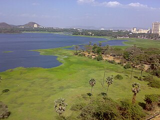
Powai Lake is an artificial lake, situated in Mumbai, in the Powai valley, where a Powai village with a cluster of huts existed. The city suburb called Powai shares its name with the lake. Indian Institute of Technology Bombay, one of the premier institutions of science and technology in India, is located to the east of the lake. Another famous institution, the National Institute of Industrial Engineering (NITIE), is also located close to the lake. Housing complexes and plush hotels are developed all around the lake periphery. Population around the lake has thus substantially increased over the years.

<span class="mw-page-title-main">Powai</span> Neighborhood in Mumbai Suburban, Maharashtra, India

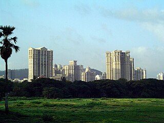
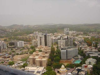
Powai is an upscale residential neighbourhood located in central Mumbai, Maharashtra, India. It is situated on the banks of Powai Lake, and is bound by the hills of Vikhroli Parksite to the south-east, Chandivali to the south-west, the L.B.S. Marg to the north-east and the Sanjay Gandhi National Park to the north beyond the lake. The Jogeshwari-Vikhroli Link Road, one of the city's busiest thoroughfares linking the western and eastern suburbs, passes through Powai,. The place also hosts thousands of devotees every year during the Ganesh Chaturthi festival for the visarjan processions.

<span class="mw-page-title-main">Mahim</span> Neighbourhood in Mumbai City, Maharashtra, India

Mahim is a neighbourhood in Mumbai, India. The Mahim railway station is in the Mahim area, on the Mumbai suburban railway on the Western Railway line. Mahim is diverse and has a church, mosque and fire-temple existing within a few meters of each other.

<span class="mw-page-title-main">Sanjay Gandhi National Park</span> National park in Mumbai, India

Sanjay Gandhi National Park, also known as SGNP, is an 87 km2 (34 sq mi) protected area in Mumbai, Maharashtra. It was established in 1969 with its headquarters situated at Borivali.

<span class="mw-page-title-main">Salsette Island</span> Island off the coast of Maharashtra, India

Salsette Island is an island in Konkan division of the state of Maharashtra on India's west coast. Administratively known as the Greater Mumbai, the city district of Mumbai, Mumbai Suburban District, Mira Bhayander and a portion of Thane lie within it, making it very populous and one of the most densely populated islands in the world. It has a population of more 20 million inhabitants living on an area of about 619 square kilometres (239 sq mi).

<span class="mw-page-title-main">Tulsi Lake</span> Lake in India

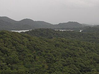
Tulsi Lake is a fresh water lake in northern Mumbai. It is stated to be the second largest lake in Mumbai and supplies part of the city's potable water. This is one of the three lakes located in the Salsette Island; the other two being Powai Lake and Vihar Lake. Both Tulsi lake and Vihar lake are located within the densely forested Sanjay Gandhi National Park or also known popularly as the Borivali National Park (BNP).

<span class="mw-page-title-main">Geography of Mumbai</span>

Mumbai (Bombay) is India's most populous city with a population of 20 Million. It is located on Salsette Island off the coast of Maharashtra. The original seven islands of Bombay were merged by the British in the 18th century, to form one large island.

<span class="mw-page-title-main">Mithi River</span> River in Mumbai, India

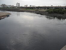
The Mithi River is a river on Salsette Island, the island of the city of Mumbai, India. It is a confluence of tail-water discharges of the Powai and Vihar lakes. The river is seasonal and rises during the monsoons. The overflowing lakes also contribute to the river flow, which is stopped by a dam at other times. During this season, the gutter is a favourite with anglers, who can catch large fish that have escaped from the lakes. Chattrapati Shivaji Maharaj International Airport is located right next to the section of river at Andheri (E).

The Brihanmumbai Stormwater Disposal System is a project planned to overhaul Mumbai's water drainage system. The estimated budget for implementing the project is Rs. 12 billion as of August 2005. Such a high-budget project would require funds from the Central Government. Mumbai has a drainage system, which in many places, are more than 100 years old, consisting of 2,000 km of open drains, 440 km of closed drains, 186 outfalls and more than 30,000 water entrances. The capacity of most of the drains is around 25 mm of rain per hour during low tide, which is exceeded routinely during the monsoon season in Mumbai, which witness more than 1400 mm during June and July. The drain system works with the aid of gravity, with no pumping stations to speed up the drainage. Most of the storm water drains are also choked due to the dumping of garbage by citizens. Portions of Mumbai like Bombay Central and Tardeo remain below sea level. Reclamation of ponds and obstructions in drains due to cables and gas pipe exacerbate the problem.

<span class="mw-page-title-main">Mumbai Suburban district</span> District of Maharashtra in India

Mumbai Suburban district is the second most populous district of Maharashtra in the Konkan Division. With its administrative headquarters in Bandra, the district consists of three subdivisions or tehsils (townships): Kurla, Andheri, and Borivali. The district along with Mumbai City district and other suburban localities make up Greater Mumbai. The district occupies an area of 446 km2.

<span class="mw-page-title-main">Mahim Bay</span> Inlet of the Arabian Sea in Mumbai

Mahim Bay is a bay, part of the Arabian Sea in Mumbai, India. The southern end is Worli, northern end is Bandra Reclamation and Mahim is in the centre. The bay was named after the islands of Mahim and Salsette were merged in the early 19th century. The Mithi River drains into Mahim Creek which drains into the Bay, and forms the border between the city and its suburbs.

<span class="mw-page-title-main">Dahisar River</span> River in India

Dahisar River is a river on Salsette island that runs through Dahisar, a suburb of Mumbai, India. It originates in the Tulsi Lake in Sanjay Gandhi National Park in the northern reaches of the city. The River flows roughly North-West for a total of 12 kilometres through the localities of the National Park, Sri Krishna Nagar, Daulatnagar, Leprosy Colony, Kandar Pada, Sanjay Nagar, and Dahisar Gaothan before meeting the Arabian sea via the Manori Creek. Its total Catchment area is 3488 hectares.

The 2006 Mumbai "sweet" seawater incident was a strange phenomenon during which residents of Mumbai claimed that the water at Mahim Creek had suddenly turned sweet. Within hours, residents of Gujarat claimed that seawater at Tithal beach had turned sweet as well. This caused a mass hysteria among people who started coming in large numbers to drink the sea water.

River Tasso is a river in Mumbai (Bombay), India which empties into the Vihar Lake. It originates in the Sanjay Gandhi National Park. In 1872, the plan was made to dam and redirect the river into the Tulsi Lake at a then cost of Rs. 40 lakh (4,000,000).

Western Suburbs (Mumbai) Precinct of Greater Mumbai in Maharashtra, India

The Western Suburbs is the western precinct of the city of Mumbai, India. The Western Suburbs consist of Andheri, Bandra, Bhayander, Borivali, Dahisar, Goregaon, Jogeshwari, Juhu, Kandivali, Khar, Malad, Mira Road, Santacruz and Vile Parle. Geographically, the Western Suburbs lie at the western part of Salsette Island, is a continuous urban sprawl spanning the areas from Bandra to Bhayander, which is separated by the Vasai Creek from Vasai-Virar city and Mithi River from Mumbai city.

<span class="mw-page-title-main">Eastern Suburbs (Mumbai)</span> Precinct of Mumbai in Maharashtra, India

East Mumbai consists the localities of Bhandup, Ghatkopar, Kanjurmarg, Kurla, Mulund, Nahur, Powai, Thane, Vidyavihar and Vikhroli. To the south-east lie the neighborhoods of Chembur, Govandi, Mankhurd, Trombay and Wadala.

<span class="mw-page-title-main">Jogeshwari–Vikhroli Link Road</span> Road in Mumbai

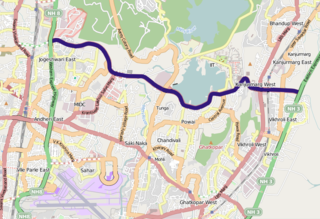
The Jogeshwari – Vikhroli Link Road (JVLR), is a 10.6-kilometre-long (6.6 mi) 6-lane road with a central median in Mumbai which connects the Western Express Highway and Eastern Express Highway providing speedier access from Jogeshwari in the Western Suburbs to Vikhroli in the Eastern Suburbs. It was opened to traffic in 1994, and widened from two to six lanes in 2012 at a cost of 221.45 crore. The under-construction Line 6 of the Mumbai Metro is being constructed on this link road.

Tourism in Mumbai

Tourism in Mumbai (Bombay) is an industry that attracts almost 6 million tourists per year, making it the 30th-most visited location worldwide. According to United Nations, as of 2018, Mumbai was the second most populous city in India after Delhi and the seventh most populous city in the world with a population of 19.98 million.

References

  1. 1 2 Bombay water supply history
  2. 1 2 3 4 "History of Water Supply". Mumbai Pages. 21 July 1997. Retrieved 17 June 2018.
  3. About Mumbai in Brief
  4. A design for echo sustainability: lessons from a stressed environment in Mumbai
  5. http://www.sanctuaryasia.com/greentips/whosewaterisit.pdf,Whose%5B%5D Water Booklet
  6. http://www.webindia123.com/city/maharashtra/mumbai/around1.htm Mumbai
  7. 1 2 "Archived copy" (PDF). Archived from the original (PDF) on 16 February 2012. Retrieved 30 August 2012.{{cite web}}: CS1 maint: archived copy as title (link) A design for echo sustainability: lessons from a stressed environment in Mumbai
  8. "Maharashtra State Gazetteers - Greater Bombay District". Archived from the original on 24 June 2008. Retrieved 20 September 2008. Maharashtra State Gazetteers
  9. Sanjay Gandhi National Park (SGNP)
  10. Hussainy, S. U. (1967). "Studies on the limnology and primary production of a tropical lake". Hydrobiologia. 30 (3–4): 335–352. doi:10.1007/BF00964021. S2CID   2787988.
  11. http://www.keral.com/Highlights/Sea_water_turns_sweet_in_Mumbai.htm.,%5B%5D Sea water turns sweet
  12. http://www.zeenews.com/articles.asp?aid=316456&sid=NAT Sweet` water attracts thousands to Mumbai beach