Ulhas River

Last updated

Ulhas River
Karjat - panoramio.jpg
Geographybombay.png
Location
Country India
State Maharashtra
Cities Mumbai, Thane
Physical characteristics
Source Western Ghats
  location India
Mouth  
  location
Arabian Sea, India
Length122 km (76 mi)

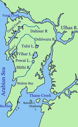
The Ulhas River is a river in Maharashtra, India. It is in the Thane, Raigad, and Pune districts of that state. It flows north and west from it source to where it splits into Vasai Creek and Thane Creek, near Thane. The Ulhas divides Salsette Island from the mainland, and is important for the water supply of Mumbai. [1] [2] [3]

Contents

See also

Related Research Articles

<span class="mw-page-title-main">Thane</span> City in Maharashtra, India

Thane is a metropolitan city located on the northwestern side of the state of Maharashtra in India. It is an immediate neighbour of Mumbai city proper, and a part of the Mumbai Metropolitan Region. It is situated in the north-eastern portion of the Salsette Island.

<span class="mw-page-title-main">Kalyan</span> City in Maharashtra, India

Kalyan is a city on the banks of Ulhas River in Thane district of Maharashtra state in Konkan division. It is governed by Kalyan-Dombivli Municipal Corporation. Kalyan is a subdivision (Taluka) of Thane district. Kalyan and its neighbouring township of Dombivli jointly form Kalyan-Dombivli Municipal Corporation, abbreviated as KDMC. It is a founding city of the Mumbai Metropolitan Region. Kalyan is the 7th biggest city in Maharashtra and 29th in India. Kalyan also serves as a major railway station for the trains bound to Mumbai and is a large junction separating two routes, one going Karjat and other Kasara.

<span class="mw-page-title-main">Thane district</span> District of Maharashtra in India

Thane district is a district in the Konkan Division of Maharashtra, India. At the 2011 Census it was the most populated district in the country, with 11,060,148 inhabitants; however, in August 2014 the district was split into two with the creation of a new Palghar district, leaving the reduced Thane district with a 2011 Census population of 8,070,032. The headquarters of the district is the city of Thane. Other major cities in the district are Navi Mumbai, Kalyan-Dombivli, Mira-Bhayander, Bhiwandi, Ulhasnagar, Ambarnath, Badlapur, Murbad and Shahapur.

<span class="mw-page-title-main">Salsette Island</span> Island off the coast of Maharashtra, India

Salsette Island is an island in Konkan division of the state of Maharashtra, on India's west coast. Administratively known as Greater Mumbai, the city district of Mumbai, Mumbai Suburban district, Mira Bhayander, and a portion of Thane lie within it, making it very populous and one of the most densely populated islands in the world. It has a population of more than 20 million inhabitants living on an area of about 619 square kilometres (239 sq mi).

<span class="mw-page-title-main">Alibag</span> Place in Maharashtra, India

Alibag, also known as Alibaug, is a coastal city and a municipal council in Raigad district of Maharashtra, India. It is the headquarters of the Raigad district and is south of the city of Mumbai. Alibag is part of the Mumbai Metropolitan Region and is situated at a distance of about 96 km from Mumbai and 143 km from Pune. Alibag is a holy place for Goddess Shree Padmakshi Renuka. She is also known as goddess of Konkan.

Dombivli is a suburban city located on the banks of Ulhas River in Thane district of Maharashtra, India. It is part of Mumbai Metropolitan Region. One of the busiest railway stations of the Central Railway, Dombivli Railway Station is located here making Dombivli an important place. This city is a cultural hub and an economically developing city along with Kalyan. Dombivli-Kalyan have been declared as a satellite city to Mumbai and is also becoming a Smart City with rapid development. Dombivli along with Kalyan has one of the highest literacy rate of 93% in the state of Maharashtra.

<span class="mw-page-title-main">Thane Creek</span> Neighbourhood in Mumbai, Maharashtra, India

Thane Creek is an inlet in the shoreline of the Arabian Sea that isolates the city of Mumbai from the Konkan region of the Indian mainland. It comprises the area between Mumbra Retibunder and the Mankhurd-Vashi Bridge. The creek is divided into two parts. The first part lies between Ghodbunder and Thane (Thana), a section from where the Ulhas river flows from the north of Mumbai Island to meet the Arabian Sea on the west. The second part of the waterway lies between the city of Thane and the Arabian Sea at Trombay / Uran, before the Gharapuri islands.

<span class="mw-page-title-main">Mumbai Harbour</span> Neighbourhood in Mumbai, Maharashtra, India

Mumbai Harbour, is a natural deep-water harbour in the southern portion of the Ulhas River estuary. The narrower, northern part of the estuary is called Thana Creek. The harbour opens to the Arabian Sea to the south. The historical island of Elephanta is one of the six islands that lie in the harbour.

<span class="mw-page-title-main">Badlapur</span> Place in Maharashtra, India

Badlapur is a city in Thane district, Maharashtra state, India, and is a part of Mumbai Metropolitan Region. Badlapur is a city on the banks of Ulhas River in Thane district of Maharashtra state in Konkan division. It is governed by Kulgaon-Badlapur Municipal Council.Badlapur is a city located just 40 km from Thane City in Thane district, Maharashtra, India. This city is a part of Mumbai Metropolitan Region managed by Municipal Council. The current estimated population of Badlapur city in 2023 is 238,000. It has a Badlapur railway station on the Central line of the Mumbai Suburban Railway

Panvel is a city and taluka in Raigad district of Maharashtra, India. It is highly populated due to its closeness to Mumbai. Panvel is also governed for development purpose by the body of Mumbai Metropolitan Region. Panvel Municipal Corporation is the first Municipal Corporation in Raigad and the 27th Municipal corporation of Maharashtra State.

<span class="mw-page-title-main">Vasai Creek</span> Creek in Maharashtra, India

Vasai Creek, previously Bassein Creek, is an estuary and one of the two main distributaries of the Ulhas River, in Konkan division of Maharashtra, India. The Ulhas splits at the northeast corner of Salsette island into its two main distributaries, the other one being the Thane Creek, both of which empty west into the Arabian Sea at the Bombay Harbour.

<span class="mw-page-title-main">Neral, India</span> Town in Maharashtra, India

Neral is a town in Raigad district in the Indian state of Maharashtra. It is 83 km+ developing city of Raigad district which is well connected to Panvel, Mumbai, Thane and Pune. Local people from communities like Agri, Kumbhar, Brhamin, Muslim, etc settled here because this place was key route to Matheran and vikatgad which were politically important for maratha empire, Mughal empire and East India Company. Neral to Matheran Train Route was devoloped by East India Company For traiding and colonial pourposes. hutatma vir bhai kotwal was a great hero who rebel against British Police in Neral - Matheran. The village was founded around in 12th century by Chanche family, due to heavy floods wiped out their most of the cultivating land. The place where Chanche family shifted NeralPada Many other families from surrounding villages followed the same in following years to safeguard themselves from regular floods affecting their homes, farms and animals.

<span class="mw-page-title-main">Mumbai Metropolitan Region</span> Metropolitan Area in Maharashtra, India

Mumbai Metropolitan Region, is a metropolitan area consisting of Mumbai and its satellite towns in the northern Konkan division of Maharashtra in western India. The region has an area of 6,328 square kilometres (2,443 sq mi) and with a population of over 26 million it is among the most populous metropolitan areas in the world.

<span class="mw-page-title-main">Konkan division</span> Region in Maharashtra, India

The Konkan Division is one of the six administrative divisions of Maharashtra state in India. It comprises the central portions of the Konkani region excluding Goa and Damaon, which were absorbed into Maharashtra owing to the States Reorganisation of India. Konkan Division is the western section of present-day Maharashtra, along the west coast of India. The two districts of the state capital Mumbai also fall into this division.

<span class="mw-page-title-main">Raigad district</span> District of Maharashtra in India

Raigad district, previously Colaba district, is a district in the Konkan division of Maharashtra, India. The headquarters of the district is Alibag. Other major cities in the district are Panvel, Karjat, Navi Mumbai, Khopoli, Shrivardhan and Mahad.

Datiware is a village in the state of Maharashtra in India on the northern bank of Datiware creek at the mouth of the river Vaitarna. This area is especially famous for its birds and is a popular destination for birdwatchers in winter.

<span class="mw-page-title-main">Wagle Estate</span>

The Wagle Estate is the industrial area of Thane city established in 1962.

Kalyan taluka is a taluka of the Thane district of Maharashtra in Konkan division. It is located between 19°4' and 19°24'N. and 73°1' and 73°24'E with an area of 276 square miles (710 km2). The capital is the city of Kalyan.

Airoli Assembly constituency is one of the 288 Vidhan Sabha constituencies of Maharashtra state in western India.

<span class="mw-page-title-main">Palghar district</span> District Of Maharashtra in India

Palghar District is a district in the state of Maharashtra in Konkan Division. The headquarters of the district is the town of Palghar. Other major cities in the district are Vasai-Virar, Talasari, Jawhar and Dahanu.

References

  1. Lewis, Clara (18 March 2013). "Greens: Monitor discharge in Ulhas river". Mumbai: Times of India . Retrieved 14 July 2014.
  2. "District Census Handbook Thane" (PDF). Census of India . 2011. Archived from the original (PDF) on 16 November 2020.
  3. "MAHARASHTRA - DISTRICT CENSUS HANDBOOK" (PDF). Archived from the original (PDF) on 14 November 2016.

19°18′N72°50′E / 19.300°N 72.833°E / 19.300; 72.833