Tillari (Forebay) Dam

Last updated

Tillari Dam
India Maharashtra relief map.svg
Red pog.svg
Location of Tillari Dam in Maharashtra
Official nameTillari (Forebay) Dam D04936
LocationChandgad
Coordinates 15°45′36″N74°07′17″E / 15.759875°N 74.121323°E / 15.759875; 74.121323
Opening date1985 [1]
Owner(s) Government of Maharashtra, India
Dam and spillways
Type of dam Gravity
ImpoundsKharani Nalla
Height22.74 m (74.6 ft)
Length350 m (1,150 ft)
Reservoir
Total capacity1,514 km3 (363 cu mi)

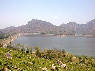
Tilari (Forebay) Dam is situated in Dodamarg Taluka, in the Indian state of Maharashtra and the largest one is situated in Chandgad taluk of Kolhapur District in Maharashtra and is constructed on Tilari River as the result of a joint project by the Maharashtra and Goa governments. The water from this dam is distributed to both states. The dam is located near the border of Maharashtra and Karnataka and necessitated the relocation of several villages in the area. There are many reservoirs. The largest one is located near Belgaum in a village named Hajgoli in Maharashtra. The village is approximately 30 km from Belgaum and is a weekend spot for the people of that town.

"There has been no official ribbon-cutting function, no fanfare and no announcements, but the Rs 15 billion Tilari dam, a joint venture between Goa and Maharashtra, is now complete. The construction of the dam began in 1986."

"The Tillari dam was completed in all respects in May 2009," S Paramasivan, managing director of the Tillari irrigation development corporation told TOI on Wednesday.[ when? ] "The topmost layer of the gorge-filling was completed in 2008 but the stone pitching and the erection of the four spillway gates was completed in May 2009," Paramasivan said."[ attribution needed ]

The full storage of the Tillari dam will however only be done after two seasons considering the stability of the dam. "Since this is an earthen dam, the storage has to be raised in stages. But as far as Goa is concerned, the dam is complete," Paramasivan said.

The dam may have[ clarification needed ] been completed now, but the waters of the Tillari dam began flowing into Goa long time back. The right bank main canal running up to Pernem was inaugurated on 19 December 2001, and the left bank main canal running into Bicholim was inaugurated on 16 February 2007.

Presently, the dam water meets the drinking water and industrial demands of three talukas in North Goa: Bicholim, Pernem and Bardez. Tillari supplies 7.5 million litres per day to the Chandel water treatment plant in Pernem and 90 million litres per day to the Assonora water treatment plant in Bardez. "But this is only because the treatment plants do not have the capacity to treat more water. PWD is increasing the capacity and we can supply whatever quantum of water they need," Paramasivan said.

Presently the right bank main canal supplies 7.5 million imperial gallons (34,000 m3) per day to Pernem and the left bank main canal supplies 18.5 million imperial gallons (84,000 m3) per day to Bicholim. But the original project provision is for the supply of 52 million imperial gallons (240,000 m3) per day from the year 2011 onwards.

The total irrigation potential of the Tillari irrigation project in Goa is 1862 hectares, comprising 1139 hectares on the right bank main canal and 723 hectare on the left. But as of March 2009, only 301 hectares have been brought under cultivation on the right bank main canal and 165 hectares on the left bank main canal. While a total of 466 hectares have been brought under cultivation, the balance 1396 hectares will be brought under cultivation during 2009–10, Paramasivan said.

The original estimated cost of the project in 1986 was Rs 2.12 billion. Now[ when? ] it has risen to about Rs 15 billion. Of this, Goa's liability is about Rs 11 billion.

Related Research Articles

<span class="mw-page-title-main">Daman Ganga River</span> River in western India

The Daman Ganga also called Dawan River is a river in western India. The river's headwaters are on the western slope of the Western Ghats range, and it flows west into the Arabian Sea. The river flows through Maharashtra and Gujarat states, as well as the Union territory of Dadra and Nagar Haveli and Daman and Diu. The industrial towns of Vapi, Dadra and Silvassa lie on the north bank of the river, and the town of Daman occupies both banks of the river's estuary.

<span class="mw-page-title-main">San Luis Dam</span> Dam in Merced County, California

San Luis Dam, also known as B.F. Sisk Dam, is a major earth-filled dam in Merced County, California, which forms San Luis Reservoir, the largest off-stream reservoir in the United States. The dam and reservoir are located in the Diablo Range to the east of Pacheco Pass and about 10 miles (16 km) west of Los Banos. San Luis Dam, a jointly-owned state and federal facility, stores more than 2 million acre feet (2.5 km3) of water for the California State Water Project and the federal Central Valley Project. Although the dam is located in the valley of San Luis Creek, the majority of its water comes from man-made aqueducts which are supplied from other rivers in Northern California.

<span class="mw-page-title-main">Pothundi Dam</span> Dam in Palakkad District, Kerala

Pothundi Dam is an irrigation dam near Pothundi village in the Palakkad district of Kerala state, India. Constructed in the 19th century, it is considered one of the oldest dams in India. It provides irrigation to an area of 5,470 hectares in the Palakkad district and drinking water supply to the Nemmara, Ayalur, Melarcode Panchayat. An unusual feature of the earth dam is the core wall, which is built with a mixture of jaggery and quick lime.

<span class="mw-page-title-main">Sukkur Barrage</span>

Sukkur Barrage is a barrage on the River Indus near the city of Sukkur in the Sindh province of Pakistan. The barrage was built during the British Raj from 1923 to 1932 and was named Lloyd Barrage. The Sukkur Barrage, is the pride of Pakistan's irrigation system as it is the largest single irrigation network of its kind in the world. It irrigates from Sukkur district in the north, to Mirpurkhas/Tharparkar and Hyderabad districts in the south of Sindh, almost all parts of the province. It is situated about 500 kilometres northeast of Karachi, 5 kilometres below the railway bridge, or the Sukkur Gorge. The introduction of barrage-controlled irrigation system resulted in more timely water supplies for the existing cultivated areas of Sindh province of Pakistan.

<span class="mw-page-title-main">Guddu Barrage</span> Dam or barrage on a river

Guddu Barrage is a barrage on the Indus River near Kashmore in the Sindh province of Pakistan. President Iskander Mirza laid the foundation-stone of Guddu Barrage on 2 February 1957. The barrage was completed in 1962 at a cost of 474.8 million rupees and inaugurated by Field Marshal Ayub Khan in 1962.

Ghataprabha is a village in the southern state of Karnataka, in north Karnataka India. It is located in the Gokak taluk of Belgaum district in Karnataka.

Dodamarg taluka is a taluka in Sindhudurg district in the Indian state of Maharashtra.

Chandgad is a Small city and tehsil headquarters of chandgad taluka, of Kolhapur district that is in the Indian state of Maharashtra.

<span class="mw-page-title-main">Ujjani Dam</span> Dam in Madha Taluka, Solapur district

Ujjani Dam, also known as Bhima Dam or Bhima Irrigation Project, on the Bhima River, a tributary of the Krishna River, is an earthfill cum Masonry gravity dam located near Ujjani village of Madha Taluk in Solapur district of the state of Maharashtra in India.

<span class="mw-page-title-main">Jayakwadi Dam</span> Dam in Maharashtra, India

Jayakwadi dam is an earthen dam located on Godavari river at the site of Jayakwadi village in Paithan taluka of Sambhajinagar district in Maharashtra, India. It is a multipurpose project. The water is mainly used to irrigate agricultural land in the drought-prone Marathwada region of the state. It also provides water for drinking and industrial usage to nearby towns and villages and to the municipalities and industrial areas of Sambhajinagar and Jalna districts. The surrounding area of the dam has a garden and a bird sanctuary.

<span class="mw-page-title-main">Majalgaon Dam</span> Dam in Majalgaon

Majalgaon Dam is an earthfill dam on the Sindphana River near Majalgaon, Beed district in the state of Maharashtra, India.

<span class="mw-page-title-main">Upper Wardha Dam</span> Dam in Maharashtra, India

The Upper Wardha Dam is an earthfill straight gravity dam across the Wardha River, a tributary of the Godavari River, near Simbhora village in Morshi taluk in Amravati district in the Indian state of Maharashtra. The dam provides multipurpose benefits of irrigation, drinking water supply, flood control and hydropower generation.

<span class="mw-page-title-main">Salaulim Dam</span> Dam in South Goa District, Goa

The Selaulim Dam is located on the Selaulim River, a tributary of the Zuari River in Goa, India. It is an integral component of the Selaulim Irrigation Project which envisages benefits of irrigation and drinking water supply. The dam is a composite earth+masonry dam of 42.7 metres (140 ft) height with a water spread area of 24 km2 (9.3 sq mi).

<span class="mw-page-title-main">Pazhassi Dam</span> Dam in Kerala, India

The Pazhassi Dam also called Kulur Barrage is a stone masonry diversion structure in Kannur district, Kerala, India. It is named after king Pazhassi Raja, a patriot who died a heroic death in the war. The dam is constructed across the west flowing Bavali river near Veliyambra. It was commissioned by Prime Minister Morarji Desai in 1979. It mainly functions as an irrigation dam, serving a command area of 11,525 hectares in Iritty taluk of the Kannur District. The water from this dam also meets the drinking water requirement of Kannur district. The dam site and the reservoir are known for their scenery.

<span class="mw-page-title-main">Irrigation in India</span> History and evolution

Irrigation in India includes a network of major and minor canals from Indian rivers, groundwater well based systems, tanks, and other rainwater harvesting projects for agricultural activities. Of these groundwater system is the largest. In 2013–14, only about 36.7% of total agricultural land in India was reliably irrigated, and remaining 2/3 cultivated land in India is dependent on monsoons. 65% of the irrigation in India is from groundwater. Currently about 51% of the agricultural area cultivating food grains is covered by irrigation. The rest of the area is dependent on rainfall which is most of the times unreliable and unpredictable.

<span class="mw-page-title-main">Kanjirapuzha Dam</span> Dam in Kerala, India

The Kanjirapuzha Dam, a masonry earth dam built for providing irrigation to a Cultural Command Area (CCA) of 9,713 hectares, is located in the Palakkad district in the Indian state of Kerala. The reservoir, which has three islands within it, also has an established commercial fisheries development programme operated by the Fisheries Department.

The 2019 Indian floods were a series of floods that affected over thirteen states in late July and early August 2019, due to excessive rains. At least 200 people died and about a million people were displaced. Karnataka and Maharashtra were the most severely affected states. People died but many were rescued with the help of the Indian Navy.

<span class="mw-page-title-main">Pirna, Goa</span> Village in Goa, India

Pirna is a village in the North Goa sub-district or taluka of Bardez and is located in the northern edge of the sub-district. It is close to the Colvale river and is the home of the 150-metre long Pirna-Ozarim bridge at Thorli Chandai. The bridge connects Pirna in Bardez taluka with Pernem taluka. It was inaugurated in May 2006.

<span class="mw-page-title-main">Raneache Zuem</span> Island in Goa, India

RaneacheZuem is a small island situated within the North Goa district of Goa, a coastal state in India. It is in close proximity to the village of Revora, with the two connected by a well-known tourist spot called Zuem Bridge. This small island, located on the banks of the Chapora River, is home to approximately 26 to 30 houses. Administratively, the island falls under the jurisdiction of the Nadora village panchayat, which is part of the Bardez Taluka.

References

  1. "Tillar (Forebay) D04936" . Retrieved 2 April 2013.