Savitri River

Last updated

Savitri
River Savitri in Konkan.jpg
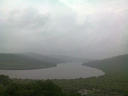
Savitri River in Konkan
Location
Country India
State Maharashtra
Physical characteristics
SourceSavitri Point, Mahabaleshwar
Mouth  
  location
Bankot creek, Near Harihareshwar, Konkan, Arabian Sea
LengthAround 110 km (68 mi)
Savitri river and adjoining valley as seen from top of Mahabaleshwar hill Savitri river 1.jpg
Savitri river and adjoining valley as seen from top of Mahabaleshwar hill
Savitri river near Mahad Savitri river.JPG
Savitri river near Mahad

Savitri River is one of the five rivers which originate from Mahabaleshwar in Maharashtra state in India. It originates at Savitri point near Mahabaleshwar and flows through the bankot village and directly goes to Arabian sea Raigad district [1] and eventually meets Arabian Sea at Harehareshwar. It passes through rocky and hilly terrain of western ghats till Poladpur and further through the towns of Mahad, Mangaon and Shrivardhan Tehsil (taluka). There are a number of Shiva temples along the banks of river Savitri. Many other small rivers get merged into it at Kapade, Poladpur and Birwadi. Its major tributary is the Kal River which enters from the right (north) near Dasgaon. [2]

More than 24 people were reported missing, on 3 August 2016, when a British era bridge collapsed due to heavy rains near Raigad district. [3] Two state transport buses and several vehicles reportedly plunged into the river. [4]

The other four rivers originating from Mahabaleshwar (Panchganga) are: Gayatri River, Koyna River, Krishna River, and Venna River.

Related Research Articles

Mahabaleshwar is a small town and a municipal council in Satara district, Maharashtra, India. It is a place of pilgrimage for Hindus because Krishna river has its origin here. The British colonial rulers developed the town as a hill station, and served as the summer capital of Bombay Presidency during the British Raj.

<span class="mw-page-title-main">Koyna River</span> River in India

The Koyna River is a tributary of the Krishna River which originates in Mahableshwar, Satara district, western Maharashtra, India. It rises near Mahabaleshwar, a famous hill station in the Western Ghats. Unlike most of the other rivers in Maharashtra which flow East-West direction, the Koyna river flows in North-South direction. The Koyna River is famous for the Koyna Dam and the Koyna Hydroelectric Project. Koyna Hydroelectric Project is the 2nd largest completed hydroelectric project in India. The reservoir – Shivasagar Lake, is a huge lake of 50 km in length.

<span class="mw-page-title-main">Roha</span> Town in Maharashtra, Roha India

Roha is a town and taluka in the Raigad district of the Maharashtra state of India. It is located 120 km southeast of Mumbai. It is the starting point of Konkan railways and end point of central railways (Mumbai). Many chemical industries have opened up their manufacturing bases in Roha. Roha is located between the banks of the Kundalika River and the hills of Kalasgiri. It has a population of over 20,849. Roha is connected to Mumbai by Panvel-Roha railway line. Roha is also the northern end of the Konkan Railway. Roha is off of the Mumbai Goa Highway, via the Kolad road.

Panvel is a city and taluka in Raigad district of Maharashtra, India. It is highly populated due to its closeness to Mumbai. Panvel is also governed for development purpose by the body of Mumbai Metropolitan Region. Panvel Municipal Corporation is the first Municipal Corporation in Raigad and the 27th Municipal corporation of Maharashtra State.

<span class="mw-page-title-main">Raigad district</span> District of Maharashtra in India

Raigad district, previously Colaba district, is a district in the Konkan division of Maharashtra, India.

<span class="mw-page-title-main">Mahad</span> City & Sub-district in Maharashtra , India

Mahad is a city in Raigad district situated in the North Konkan region of Maharashtra state, India. It is located 108.5 km (67.4 mi) from District's headquarter Alibag, and 167 km (104 mi) from Mumbai. Mahad is known for Raigad Fort, the capital of the Maratha Empire in Shivaji's era and the revolutionary Mahad Satyagraha launched by at Chavdar Tale in the wake of modern India.

<span class="mw-page-title-main">Chiplun</span> City in Maharashtra, India

Chiplun is a city in Ratnagiri district in the state of Maharashtra, India. It is the financial and commercial Hub of Ratnagiri, and the headquarters of Chiplun taluka. It is about 320 km south of Mumbai in the Konkan region of Maharashtra, on the Mumbai–Goa highway (NH-66). It has a long history and a strong cultural background. Recent decades have seen much industrial development in it and its and surrounding areas.

Nagothana is a census town in Roha Taluka, in the Raigad district of the Indian state of Maharashtra. The Kanyakumari - Panvel National Highway # 66 (NH66) goes through this town.

Poladpur is a census town in Raigad district in the Indian state of Maharashtra.

Mandangad is the headquarters of Mandangad taluka the northmost taluka in Ratnagiri district of Maharashtra, India.

Devale is a small village located in Poladpur Tehsil, in Raigad district, Maharashtra, India.

Chandgad is a Small city and tehsil headquarters of chandgad taluka, of Kolhapur district that is in the Indian state of Maharashtra.

<span class="mw-page-title-main">Tarkarli</span> Village in Maharashtra

Tarkarli is a village in Malvan taluka in Sindhudurg district in the Indian state of Maharashtra. It is a beach destination and remote place in southern Maharashtra. Few years ago, Tarkarli beach is declared as a Queen Beach of Konkan region. Monthly, Thousands of tourists are visiting this place to rejuvenate and enjoy thrill of water sports activities. All Watersports activities in Tarkarli are going on as per international safety of standards and under guidance of professional instructor(Dive Master) with modern safety equipment. Many scuba diving operators running this activities near Tsunami island, Devbag because of shallow water and low life risk.

Palaspe is located in near Panvel in Raigad district in Maharashtra, India.

Poladpur-Naneghol is a small village in Raigad District, Maharashtra, India.

Savitri Dam, is a gravity dam on Savitri River near Poladpur, Raigad district in state of Maharashtra in India.

<span class="mw-page-title-main">Ambenali ghat</span> Mountain road in Maharashtra, India

Ambenali Ghat is a mountain road in Maharashtra, India cutting across the Northern Western Ghats or the Sahyadri mountain range. It connects the coastal Raigad District Konkan region of Maharashtra with the Satara District Desh region on the Deccan plateau. It is one of few link roads between the Konkan and Ghatmaatha in Maharashtra. The road, state highway 72, is at an average elevation of 625 m (2,051 ft). The ghat, or mountain road, is about 40 km long. Its characteristic feature is that it takes many turns without gaining/losing much height. It links the cities of Poladpur and Mahabaleshwar. It ends in Poladpur. The road ascends/descends around 1300m from Mahabaleshwar to Poladpur. It is the longest ghat in Maharashtra.This ghat travels through the Javali forest area. Many animals like leopards are seen here. This 40 km long ghat is known for its deadly road, where many accidents take place. It is very scenic and its picturesque landscape makes it an ideal location for tourists who flock around the ghat in crowds.

National Highway 66, commonly referred to as NH 66, is a mostly 4 lane 1,608 km (999 mi) long busy National Highway that runs roughly north–south along the western coast of India, parallel to the Western Ghats. It connects Panvel to Cape Comorin (Kanyakumari), passing through the states of Maharashtra, Goa, Karnataka, Kerala and Tamil Nadu.

<span class="mw-page-title-main">Surgad</span>

Surgad, is a hill fort located in a spur, fragmented from the Sahyadri ranges of Maharashtra. The fort is situated near Roha, next to the village of Vaijanath in the Raigad district. This fort was an observation fort, which guarded the trade route along the Kundalika river from Sudhagad to Revdanda fort.

<span class="mw-page-title-main">Old Mahabaleshwar</span> Place in Maharashtra, India

Old Mahabaleshwar, also known as Kshetra Mahabaleshwar, is a historical village in Mahabaleshwar, of the Satara district in the Indian state of Maharashtra. It is a hill station located near the Western Ghats, seven kilometers from Mahabaleshwar. It is home to three temples: the Panchganga temple, Mahabaleshwar temple, and Krishna temple.

References

  1. Deshpande, Swati (18 November 2011). "No sand mining till green nod, HC tells Maharashtra govt". Times of India . Mumbai. Retrieved 3 March 2015.
  2. Savitri river basin
  3. "Mumbai-Goa highway bridge collapses, 2 buses carrying 18 people missing". 3 August 2016. Retrieved 3 August 2016.
  4. Zanane, Anant R (3 August 2016). "2 Dead, 20 Missing As British-Era Bridge On Mumbai-Goa Highway Collapses: 10 Updates". NDTV. Retrieved 30 November 2022.

Coordinates: 17°58′N73°02′E / 17.967°N 73.033°E / 17.967; 73.033