
Kalyan is a city on the banks of Ulhas River in Thane district of Maharashtra state in Konkan division. It is governed by Kalyan-Dombivli Municipal Corporation. Kalyan is a subdivision (Taluka) of Thane district. Kalyan and its neighbouring township of Dombivli jointly form Kalyan-Dombivli Municipal Corporation, abbreviated as KDMC. It is a founding city of the Mumbai Metropolitan Region. Kalyan is the 7th biggest city in Maharashtra and 29th in India. Kalyan also serves as a major railway station for the trains bound to Mumbai and is a large junction separating two routes, one going Karjat and other Kasara.

Central Railway is one of the 19 zones of Indian Railways. Its headquarters is in Mumbai at Chhatrapati Shivaji Maharaj Terminus. It has the distinction of operating the first passenger railway line in India, which opened from Mumbai to Thane on 16 April 1853.

Lonavala-Khandala is a hill station and a Municipal Council in the Pune district, Maharashtra, India. It is about 64 km west of Pune and 96 km to the east of Mumbai. It is known for its production of the hard candy chikki and is also a major stop on the railway line connecting Mumbai and Pune. From the Pune suburbs, local trains are available from Pune Junction. Both the Mumbai-Pune Expressway as well as the Mumbai-Bengaluru highway pass through Lonavala.
Matheran is an automobile-free hill station and a municipal council in the Karjat taluka of the Raigad district located in the Indian state of Maharashtra. Matheran is part of the Mumbai Metropolitan Region, and one of the smallest hill stations in India. It is located in the Western Ghats, at an elevation of around 800 m above sea level. It is about 90 km from Mumbai, and 120 km from Pune. This proximity to these urban areas makes it a weekend getaway for many. Matheran, which means "forest on the forehead" in Marathi, is an eco-sensitive region, declared by the Ministry of Environment, Forest and Climate Change, Government of India. It is Asia's only automobile-free hill station.

Kodachadri is a mountain peak with dense forests in the Western Ghats in South India, 78 km from Shimoga. Kodachadri is the highest peak in Shivamogga district. It is declared as natural heritage site by the Karnataka Government. and it is 13th highest peak of Karnataka.
Panvel is a city and taluka in Raigad district of Maharashtra, India. It is highly populated due to its closeness to Mumbai. Panvel is also governed for development purpose by the body of Mumbai Metropolitan Region. Panvel Municipal Corporation is the first Municipal Corporation in Raigad and the 27th Municipal corporation of Maharashtra State.

Neral is a town in Raigad district in the Indian state of Maharashtra. It is 83 km+ developing city of Raigad district which is well connected to Panvel, Mumbai, Thane and Pune. Local people from communities like Agri, Kumbhar, Brhamin, Muslim, etc settled here because this place was key route to Matheran and vikatgad which were politically important for maratha empire, Mughal empire and East India Company. Neral to Matheran Train Route was devoloped by East India Company For traiding and colonial pourposes. hutatma vir bhai kotwal was a great hero who rebel against British Police in Neral - Matheran. The village was founded around in 12th century by Chanche family, due to heavy floods wiped out their most of the cultivating land. The place where Chanche family shifted NeralPada Many other families from surrounding villages followed the same in following years to safeguard themselves from regular floods affecting their homes, farms and animals.

The 12123 / 12124 Deccan Queen is a daily Indian passenger train service operated by the Central Railway zone of the Indian Railways connecting the cities of Mumbai and Pune. Introduced on June 1, 1930, the Deccan Queen was India's "first superfast train, first long-distance electric-hauled train, first vestibuled train, the first train to have a ‘women-only’ car, and the first train to feature a dining car". The service name comes from the Marathi nickname "दख्खन ची राणी", a popular nickname for Pune. Deccan Queen is currently the fastest train service linking Chhatrapati Shivaji Maharaj Terminus and Pune Junction. It has an average operating speed of 60 km/h (37 mph) including stops, and a top speed of 105 km/h (65 mph). The train's long history and common use as a commuter train has gained it significant popularity, including annual celebrations of its "birthday" on June 1 at Pune Junction. It was hauled by a Kalyan-based WCAM-3 end to end up until June 2022. From June 2022, its upgraded coaches in a new livery are being hauled by a Ajni-based WAP-7.
Ujjain is an ancient city of central India, in the Malwa region of the Indian state of Madhya Pradesh, on the eastern bank of the Kshipra River.
Raigad district, previously Colaba district, is a district in the Konkan division of Maharashtra, India. The headquarters of the district is Alibag. Other major cities in the district are Panvel, Karjat, Navi Mumbai, Khopoli, Shrivardhan and Mahad.
Murbad is a census town within the administrative division (taluka) of Thane district in the Indian state of Maharashtra. Murbad city with its neighbouring villages jointly form the Murbad nagar panchayat, which is near the cities of Thane, Karjat and Kalyan. Nearby cities include Badlapur, Ambernath, Ulhasnagar, and Dombivli. It is a largely industrial town with private and public enterprises (MIDC).

Amboli is a small village in the southern Konkan Division, Sindhudurg district, Maharashtra state, India. Amboli Ghat lies at an altitude of approximately 700 metres above sea level and is the last hill resort before ending in the coastal plains of Goa state.

Rajmachi Fort (Killa) is one of the many historical forts in the rugged hills of Sahyadri mountains. It consists of two twin fortresses Shriwardhan and Manaranjan, with a wide machi (plateau) surrounding the two Balekillas. Udhewadi is a small village of about 60 households situated on the machi, at the southern foot of Manaranjan Balekilla of Rajmachi Fort.
Banapura is a small town in the Hoshangabad District of Madhya Pradesh, India. Banapura is a twin city of Seoni Malwa.
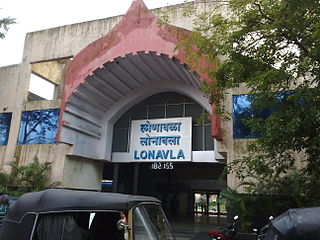
Lonavala railway station is a railway station in Lonavala, a hill station in the state of Maharashtra in India. Lonavala station is the origin of Lonavala–Pune Suburban Trains. 17 suburban trains operate on the Pune–Lonavala route. Lonavala is also a halt for Mumbai–Pune Express and Mail trains. The Karjat–Pune passenger train also has a halt at Lonavala. Trains traveling on the Kalyan–Pune route also halt at Lonavala. This station leads access to Lonavala town and nearby areas like Karla Caves, Bhaja Caves, Lohagad, Visapur Fort, Bhushi Dam and Bhor Ghat. Khandala hill station is just 8 kilometres (5.0 mi) from Lonavla.

The Siddhivinayak Temple of Siddhatek is a Hindu temple dedicated to Ganesha, the elephant-headed god of wisdom. The temple is one of the Ashtavinayaka, the eight revered shrines of Ganesha in the Indian state of Maharashtra and the only Ashtavinayaka shrine in Ahmednagar district.

Panvel railway station, station code is: PL(suburban)/PNVL(mainline)) is a railway station on the Harbour Line and Central line of the Mumbai Suburban Railway network.
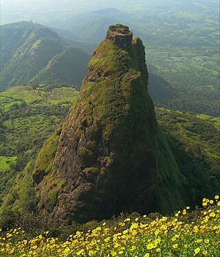
Kalavantin Durg is a 2,250 ft (686 m) high summit located in the Western Ghats, near the Prabalgad fort in the Raigad district of Maharashtra, India. It is also known as Kelve Teen, Kalavantinicha Sulka, or Kalavantin Pinnacle; alternative transliterations include Kalawantin, Kalavati, and Kalavanti. It is a popular trekking destination.
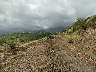
Padargad is a small fort used for vigilance in the past. is situated to the east of Karjat in the Indian state of Maharashtra. It is on the Bhimashanker trek route in the Karjat area, because of its height and difficult climbing, it is not visited by most of the trekkers.
Tungi fort is a small 16th-century fort probably mainly used as a lookout post in the past. It is situated to the east of Karjat in the Indian state of Maharashtra. It is one of the easy-to-reach forts near the Bhimashanker trek route in the Karjat area.
