Bamandongri

Last updated

Bamandongri
village
India Maharashtra location map.svg
Red pog.svg
Bamandongri
Location in Maharashtra, India
India location map.svg
Red pog.svg
Bamandongri
Bamandongri (India)
Coordinates: 18°58′16″N73°01′27″E / 18.97111°N 73.02417°E / 18.97111; 73.02417 Coordinates: 18°58′16″N73°01′27″E / 18.97111°N 73.02417°E / 18.97111; 73.02417
CountryFlag of India.svg  India
State Maharashtra
District Raigad
Languages
  Official Marathi
Time zone UTC+5:30 (IST)
PIN
410206
Nearest cityPanvel

Bamandongari is a Historical village situated in Maharashtra, India.

Maharashtra State in western India

Maharashtra is a state in the western peninsular region of India occupying a substantial portion of the Deccan plateau. It is the second-most populous state and third-largest state by area in India. Spread over 307,713 km2 (118,809 sq mi), it is bordered by the Arabian Sea to the west, the Indian states of Karnataka and Goa to the south, Telangana and Chhattisgarh to the east, Gujarat and Madhya Pradesh to the north, and the Indian union territory of Dadra and Nagar Haveli to the north west. It is also the world's second-most populous subnational entity. It was formed by merging the western and south-western parts of the Bombay State, Berar and Vidarbha, and the north-western parts of the Hyderabad State and splitting Saurashtra by the States Reorganisation Act. It has over 112 million inhabitants and its capital, Mumbai, has a population around 18 million making it the most populous urban area in India. Nagpur hosts the winter session of the state legislature. Pune is known as the 'Oxford of the East' due to the presence of several well-known educational institutions. Nashik is known as the 'Wine Capital of India' as it has the largest number of wineries and vineyards in the country.

India Country in South Asia

India, also known as the Republic of India, is a country in South Asia. It is the seventh-largest country by area, the second-most populous country, and the most populous democracy in the world. Bounded by the Indian Ocean on the south, the Arabian Sea on the southwest, and the Bay of Bengal on the southeast, it shares land borders with Pakistan to the west; China, Nepal, and Bhutan to the northeast; and Bangladesh and Myanmar to the east. In the Indian Ocean, India is in the vicinity of Sri Lanka and the Maldives; its Andaman and Nicobar Islands share a maritime border with Thailand and Indonesia.

There is Hanuman Temple in Bamandongari and also a primary school.

It is situated on the Eastern Side of Mumbai and is connected to Panvel Via State Transport Bus Service. Nearby villages include Wahal, Morave, Jawle, Gavhan, Shelghar, Shivajinagar and Kopar.

Mumbai Megacity in Maharashtra, India

Mumbai is the capital city of the Indian state of Maharashtra. As of 2011 it is the most populous city in India with an estimated city proper population of 12.4 million. The larger Mumbai Metropolitan Region is the second-most-populous metropolitan area in India, with a population of 21.3 million as of 2016. Mumbai lies on the Konkan coast on the west coast of India and has a deep natural harbour. In 2008, Mumbai was named an alpha world city. It is also the wealthiest city in India, and has the highest number of millionaires and billionaires among all cities in India. Mumbai is home to three UNESCO World Heritage Sites: the Elephanta Caves, Chhatrapati Shivaji Maharaj Terminus, and the city's distinctive ensemble of Victorian and Art Deco buildings.

Panvel Nodal City of Navi Mumbai in Maharashtra, India

Panvel is a locality in Raigad district of Maharashtra in Konkan Division, and is a node of Navi Mumbai city. It is highly populated due to its closeness to Mumbai. Panvel is located in the Mumbai Metropolitan Region. Panvel is the first Municipal Corporation in Raigad and the 27th Municipal corporation of Maharashtra State.
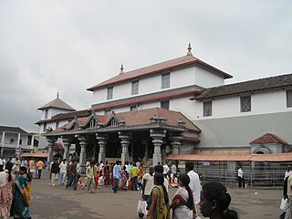
Wahal is a small village in Panvel, in the Raigad district of Maharashtra, India.

Historically Bamandongari is a village of fishermen and farmers. The primary crop is paddy. The main caste and sub-caste of the villagers is Hindu / Agri.

Nearest Place worth visiting named "Langeshwar" is just 2 km away on north-west. The place is a famous religious spot having very old 'Lord Shiva temple' situated on the sea shore in the vicinity of village Morave. "Mahashivaratri" a festival of Lord Shiva is celebrated annually here by arranging a carnival and small fair by villagers of nearby villages.

Recent developments: The project of commercial and residential buildings of Ulwe node is in progress around the village and it is now surrounded by Sector 6, Sector 9, Sector 18 and Sector 19 of Ulwe node. [1]

Ulwe Node of Navi Mumbai in Maharashtra, India

Ulwe is a node of Navi Mumbai situated at the edge of Panvel city. It is developed and maintained by CIDCO. It is located in Raigad district. Ulwe is going to be a major successful planned place to live after Vashi. It is soon going to come under the purview of the Panvel Municipal Corporation. The metro project of Navi Mumbai connects Ulwe prominently.

Proposed developments: Bamandongri railway station on the railway line connecting CBD Belapur to JNPT (Jawaharlal Nehru Port Trust) is proposed and in progress. [1]

Bamandongri railway station

Bamandongri Railway Station is a railway station in Navi Mumbai, Maharashtra. It serves Ulwe Node to Nerul & Belapur. The station consists of two platforms.

CBD Belapur Business District in Maharashtra, India

The Central Business District of Belapur is a node of Navi Mumbai. The Navi Mumbai Municipal Corporation is headquartered in Belapur. The Reserve Bank of India maintains a branch office at CBD Belapur. This area is one of the fastest developing regions in Navi Mumbai in terms of new residential and commercial construction projects. CBD Belapur is connected to other parts of Mumbai through railways, BEST & NMMT buses. It had a ferry service for traveling to Elephanta caves from Sector-11.

Related Research Articles

Navi Mumbai Newly planned township of Mumbai in India

Navi Mumbai, is a planned city off the west coast of the Indian state of Maharashtra in Konkan division. The city is divided into two parts, North Navi Mumbai and South Navi Mumbai, for the individual development of Panvel Mega City, which includes the area from Kharghar to Uran. Navi Mumbai has a population of 1,119,477 as per the 2011 provisional census.

New Panvel Node in Maharashtra, India

New Panvel is a residential, commercial and educational node of Navi Mumbai in city of Panvel, Maharashtra and comes under the Konkan division. New Panvel was developed on marshy land and was previously a Mango cultivated area. New Panvel is divided into two parts: New Panvel (E), on the eastern side of Panvel railway station and Khanda Colony or New Panvel (W) on the western side of it. Both parts of New Panvel are connected by a flyover bridge also known as Khanda Colony Flyover. New Panvel (W) is also popularly called Khanda Colony by the local villagers, as the city is adjacent to two small villages Dhakta Khanda and Motha Khanda.

Osmanabad district is an administrative district in the Marathwada region in the Indian state of Maharashtra.The district headquarter is located at Osmanabad. This primarily rural district occupies an area of 7569 km² of which 241.4 km² is urban and has a population of 1,660,311 of which 16.96% were urban.

Khordha district District in Odisha, India

Khordha is an administrative division of the state of Odisha, India. It was formed on April 1, 1993, by the division of former Puri District into Puri, Khordha and Nayagarh districts. In the year 2000 the district name was changed to Khordha. The district headquarters is Khordha Town. The capital city of Bhubaneswar is located in this district. Khordha is the most urbanized of all the districts of Odisha. Khordha Road, the railway station that serves the town is also the divisional headquarters of the East Coast Railway of the Indian Railways. Khordha is known for its brass utensils, cottage industries, railway coach manufacturing, and cable manufacturing unit.

Seawoods–Darave railway station

Seawoods–Darave is a newly developed railway station on the Harbour line of the Mumbai Suburban Railway in the Nerul node. The railway station derives its name from the famous Seawoods NRI complex developed by CIDCO especially for high income and economically well to do groups. The area has developed rapidly in recent years compared to any other nodes in Navi Mumbai due to its strategic location, having Vashi, Mumbai & Thane towards its north and Ulwe, Uran, JNPT & upcoming international airport towards is south and CBD Belapur, Kharghar & Panvel towards its east. The station is located adjacent to Sector 40 & 42, few kilometers away from Seawoods NRI complex.

Kharghar Node of Navi Mumbai in Maharashtra, India

Kharghar is a smart city of the node of Mumbai metropolis situated at the Northern most tip of Raigad district. It was developed by the City and Industrial Development Corporation i.e. CIDCO. Kharghar is located on the Sion Panvel Highway at one and half hour (approx.) drive during peak traffic hours from the heart of Mumbai city.

Idimuzhikkal village in Kerala, India

Idimuzhikkal or Chelembra is a town in Malappuram district, Kerala, India. Chelembra is the Panchayath and Idimuzhikal is the capital of this Panchayath.

Barapalli village in Odisha, India

Barapalli is a village situated 3 km from district Nayagarh in Odisha, India. The village has around 150 houses.

Kankole Village in Kerala, India

Kankol is a village in Kerala, Kannur district India. Kankol village is a part of Kankol Alapadamba Grama Panchayath, which had won the Swaraj Trophy (1999–2000) for the best grama panchayath in Kerala state. Post office and village office representing Kankol are situated in the place named Kundayamkovval.

Ganj Basoda Place in Madhya Pradesh, India

Ganj Basoda, sometimes called Basoda, is a city of municipality in the Indian state of Madhya Pradesh. Ganj Basoda is one of the eleven tehsils of Vidisha district.

Parner taluka Tehsil in Maharashtra, India

Parner taluka is a taluka in Ahmednagar district in the state of Maharashtra, India.

Gauri Pundah is a village in Fatuha development block of district Patna in the state of Bihar, India. It is situated on the banks of the river Mahatmain. This village consists of six settlements viz Gauri, Gyaspur, Abdalchak and three settlements of Pundah. Gauri Pundah thus is the largest village in the surrounding region. It has a population of more than two thousands and a half.

Kherva Village in Gujarat, India

Kherva is a village in the Mehsana District, Gujarat, India, situated on State Highway 73 between Gandhinagar and Mehsana. It borders the following villages: Devarasan, Kadavasan, Mulsan, Jagudan, Sanganpur, Punasan, Hebuva, Udalpur, Gunjala, Dharusan, and Dhamnava.

Kainipura Village in Odisha, India

Kainipura is a small village in the Kendujhar District of Orissa, India. It lies at a distance of 5 km. from Anandapur, 80 km. from the district headquarters 'Kendujhar' and 160 km. from Bhubaneswar, the state capital.

Pali, Rewari village in Haryana, India

Pali is among the bigger villages of Rewari district in Haryana state, India. Pali is situated on Rewari-Narnaul state highway no. 26, 17 km from Rewari. The village is located on a foothill. Baba Nimari Wala is a famous temple of the village situated on the hill binds the villagers in the religious and spiritual string. A road has been constructed from bottom to the mid of the hill till Baba Nimri Wala Mandir by the villagers without any government fund.

Kamashasan is one of the village in the district of Jagatsinghpur, Odisha, India. Bagula is famous for the Vegetable cultivation and its quality and varieties of vegetables in major cities Odisha.

Gothra, Rewari Place in Haryana, India

Gothra is a village on the Rewari- Narnaul road(National Highway no. 11) 15 kilometres (9.3 mi) from Rewari in Rewari district in the Indian state of Haryana. It is also named as Gothra Pali.This village is nearby Village Pali that is also on the Delhi Mumbai Freight Corridor Project including gothra which will be India's future trade corridor. The most charming thing of this village is that the Nearest Railway Station of The Pali Village from there every villagers can travel to Narnaul,Phulera,Rewari,and Delhi. Haryana's second Sainik School is situated in Gothra.For the Sanik School the villagers and whole of the Ahirwal struggled a lot for a period of 30–40 years.It was the main demand of Ahirwal. At last, Sainik school was inaugurated in 2008 by the then Hon'ble former CM Bhupender Singh Hooda.This school is situated in the lap of the hill and covers an area of 56 acre.There is also a Power House(Bijli Ghar)Sub Division in this village. Village also has many temples one of them is Sakti mata mandir in the lap of the hill. People also from the surrounding villages have a religious belief in Sakti Mata and Saturday is the main day when all the inhabitants and those of surrounding villages visit the Mandir. There is a belief that The Sakti Mata always saves the village from evils. Adjacent to the village there is Kribhco container. On the bus stand of this village there are many shops and dhabas namely Rao Dhaba, Chahat restaurant, Chaudhry dhaba, Paras Dhaba,Dehli wala Halwai,Vijay tent House, Marshal Photographer and a Petrol Pump.When travelling from Rewari to Narnaul, if you see all this on the left side of the highway, you can assume that you are at Gothra Village.Apart from this, Sainik School and Power house is also on the Bus stand of the village and at the right side of the highway is a village Gothra. Adjacent villages are Nandha,Balwari, Nangla, Mamria,Pali. There are five link roads that goes to all these villages that discussed in former statement.

 People from this village are in every field of success like judiciary, taxation, police, defence, para military, banks, teaching line and also in private sector. In India China 1962 war, Captain Ram Kunwar of this village was awarded Veer Chakra.

Deuduar is a mid-sized village located in the district of Kamrup in the state of Assam in India. It has a population of about 3500 persons living in around 300 households. It is situated almost 30 km away Guwahati. The 31 natioanal highway goes through midflr of this village.

Nurpur Jharsa is situated in Gurgaon tehsil and located in Gurgaon district of Haryana. It is one of 38 villages in Gurgaon Block along with villages like Aklimpur and Palra. Nearby railway station of Nurpur jharsa is Gurgaon. It lies in 68.

Naromurar Village in India - 257587 in Bihar

Naromurar is a Village in Warisaliganj Tehsil, located 10 km far from National Highway 31 and 8 km from State Highway 59, making it the only village of the area well connected to both Nawada and Nalanda districts of Bihar.
Literally the word Nar means water and Murar means Lord Krishna who appeared as the 8th avatara of Lord Vishnu in Dwapar yuga as mentioned in Garuda Purana, that is the word Naromurar means the house of lord Vishnu -Kshirsagar.
Naromurar is a village of great traditions. It is one of the ancient villages of India having a four hundred year older Thakur Wadi dedicated to Maryada Purushottam Ram and Lord Shiva.
Along with the Rajkiyakrit Madhya Vidyalay having established in 1920 AD, 27 years before the freedom of India, a Janta Pustakalay the Public Library is also started in the year of 1956 AD which was inaugurated by the Education Minister of Bihar during the time of Krishna Singh.

References

  1. 1 2 The Economic Times (20 November 2012). "Ulwe in Mumbai emerges as top destination for realty investment" (News). Indiatimes.com. Retrieved 26 September 2013.