Konkan, also known as the Konkan Coast or Kokan, is a rugged section of the western coastline of India. It is a 720 kilometres long coastline. It consists of the coastal districts of the Western Indian states of Maharashtra, Goa, and the South Indian state of Karnataka. The ancient Saptakonkana is a slightly larger region. The region is known as Karavali in Karnataka.

Thane District ([]) is a district in the Indian state of Maharashtra in Konkan Division. At the 2011 Census it was the most populated district in the nation, with 11,060,148 inhabitants; however, in August 2014 the district was split into two with the creation of a new Palghar district, leaving the reduced Thane district with a 2011 Census population of 8,070,032. The headquarters of the district is the city of Thane. Other major cities in the district are Navi Mumbai, Kalyan-Dombivli, Mira-Bhayander, Bhiwandi, Ulhasnagar, Ambarnath, Badlapur, Murbad and Shahapur.

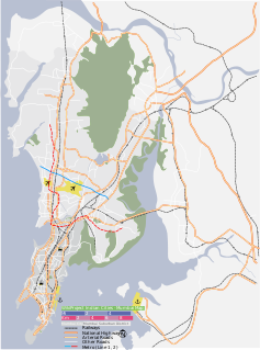
Uran is coastal town and node of Navi Mumbai, Maharashtra state in Konkan division. It lies in the Raigad district, east of Mumbai across the Dharamtar Creek. Uran is primarily a fishing and agriculture village, which has developed into the special economic zone of Uran. The primary languages spoken are Agri and Koli which is a dialect of Marathi-Kokani.

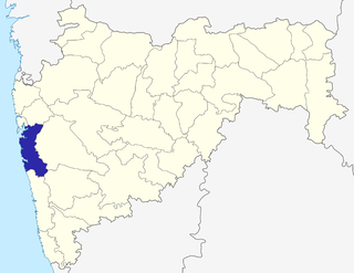
Alibag is a coastal town and a municipal council in Raigad District of Maharashtra. It is the headquarters of the Raigad district and is south of the city of Mumbai
Panvel is a locality in Raigad district of Maharashtra in Konkan Division, and is a node of Navi Mumbai city. It is highly populated due to its closeness to Mumbai. Panvel is located in the Mumbai Metropolitan Region. Panvel is the first Municipal Corporation in Raigad and the 27th Municipal corporation of Maharashtra State.

Neral is a town in Raigad district in the Indian state of Maharashtra. It is 83 km from Mumbai-South and 42 km from Panvel in the Karjat tehsil. It is a rapidly developing city of a Raigad district which is well connected to Panvel, Mumbai, Thane and Pune. Neral along with Karjat is also known as Eastern Mumbai District.
Madh Island is a group of several quaint fishing villages and farmlands in northern Mumbai.
The '"Dronagiri"' is a node of Navi Mumbai in Raigad district. It is located at Southern tip of Navi-Mumbai metropolis and spread over 1,250 hectres of land. The zone is located to the east of Uran town, and is bound by the Karanja River on the south-east. Residential areas are located to the west and north-west of the zone, while the Jawaharlal Nehru Port (JNPT) area and township are located towards the north of the zone. The zone is adjacent to the JNPT port, and is located farthest from the central business districts of Belapur, Nerul and Vashi. Due to its proximity to the port, this zone is ideal for port-based industries.

Mahadpronunciation (help·info) is a town in Raigad district(formerly Kulaba district) situated in the North Konkan region of Maharashtra state, India. It is located 108.5km from District's Headquarter Alibag, and 167km from Mumbai state capital of Maharashtra and Economic capital of India, towards Western Coast.
Poladpur is a census town in Raigad district in the Indian state of Maharashtra.
Pen is a town and taluka in Raigad district of Indian state of Maharashtra. It is well-known for world class Ganesh idols. It is geographical and cultural center of Raigad district.

Kamothe is a node of Navi Mumbai developed and maintained by CIDCO. Kamothe is located on the Sion Panvel Highway. It is the third node after Panvel and Kalamboli towards Mumbai.

The Marathi-Konkani languages are the mainland Southern Indic languages, spoken in Maharashtra and the Konkan region of India: Marathi, Maharashtrian Konkani, Konkani proper, Kukna, Phudagi, Kadodi (Samvedi), Katkari, Varli,

Ganagapura is a Village in Karnataka, India. It is located in the Afzalpur taluk of Kalaburagi district in Karnataka.The village is noted for its temple to Lord Dattatreya, who is said to have attained realization on the banks of the confluence (Sangama) of rivers Bhima-Amarja.
Underi is a fortified island near the mouth of Mumbai harbour south of Prong's Lighthouse. It is a companion fort to Khanderi and currently lies in Raigad district, Maharashtra. These islands of Khanderi and Underi served as one of the landmarks for ships entering Mumbai harbour. Underi is smaller than Khanderi.
Fort Mangad is a survey fort which is situated in Borwadi, an area near Mashidwadi in Mangaon, a taluka in Raigad district in the Indian state of Maharashtra. The fort is made sacred by the footsteps of the founder of Hindavi Swaraj, the famous Maratha king Chhatrapati Shivaji Maharaja. Mangaon is situated about 150 km from Mumbai.
Khalapur taluka is a [taluka] in [Raigad district] of Maharashtra an Indian state. The headquarters of this taluka is Khalapur village. This taluka belongs to Karjat sub-division, and comprises 141 villages, 3 revenue circles and 20 sajas. 56 villages of this taluka come under Navi Mumbai Airport Influence Notified Area (NAINA).

Dronagiri Fort is a fort in Raigad district, Maharashtra, India.