The city name is derived from the Hindu goddess Uranavati. It was called Uruvan during the rule of Madhavrao I, the fourth Peshwa of the Maratha Empire. Later, the area was named Uran by the Portuguese and Ooran by the British.[2]
The area around Mumbai, including Uran, was under Portuguese and British rule in the 16th to 19th centuries.[2]
Uran was subject to the Maratha princely states in the Maharashtra. Uran was once the base of the famous Maratha Sarkhel (Admiral) Kanhoji Angre,[5] who battled European naval interests in the 18th century.
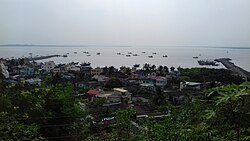
On the tip of a peninsula, Uran district is surrounded by sea on three sides. The town of Uran itself is centrally located on the peninsula, flanked by Karanja village to the south and Mora village and port to the north.
Uran is home to extensive salt pans, part of a long-standing network of salt manufacturing around Mumbai.[7] The land has been under redevelopment pressure.[8]
The Uran wetlands were once home to many species of birds and reptiles, some critically endangered. The wetlands were developed in 2009 and 2010, leaving only the Panje-Dongri wetlands.
Uran consists of multiple smaller villages and can be divided into South, North and West parts.
Villages in Southern Uran:
Economy
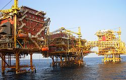
ONGC Oil and Gas Processing Platform in the Bombay High oilfieldJaskhar Fair at night in the month of April
The main occupation in Uran is fishing; 80% of the fish production of Mumbai comes from fishermen based out of the Uran in Navi Mumbai, especially the villages of Karanja and Mora.
The second major occupation is farming. Uran contributes to the production of rice in the Raigad district. Raigad is the second largest district in terms of rice production in India.
Shipping, shipbuilding, and port support are major economic factors in Uran district. Jawaharlal Nehru Port (JNPT) is the largest container terminal in India.[9] Other container terminals in the Uran district include APM Terminals (formerly GTI) and DP World (formerly the P&O). Salt pan owners revolted against the government decision to build a seaport,[when?] but the port has proved to be the main source of income to residents and nearby villages, as major projects and warehouses have opened nearby.
The Indian Navy maintains a naval base near Mora. Due to Security reasons sea travel restrictions is imposed by the Indian Navy .
Uran is growing. In the 2001 India census, Uran had a population of 23,254;[12] this had increased by the 2011 census to 30,439.[1] Males constitute 53% of the population and females 47%. In Uran, 10–11% of the population is 6years of age or younger.[1][12]
Uran's average literacy rate is also rising, from 79% in 2001 to 82% in 2011.[1][12] Female literacy lags behind male literacy: male literacy was 83% in 2001 and 85% in 2011, and female literacy was 75% in 2001 and 79% in 2011.[1][12] India's national literacy average is 59.5%.
Uran lacks of higher institutions, but some schools are considered reputed such as Dronagiri High School, St. Mary's JNP School, and Lady Khatun Marium School. These school facilitate a higher standard of education in Uran, but still are far away from the ones found in urban areas.
Bahiridev Temple, Sarde Uran:' Shree Bahiridev(Ughad) is Gramdaiwat of all Sarde Village. It is Jagrut Devasthan and it is based on Creek of Sarde which is one of branch of Patalganga Creek.
Raghoba Mandir Is a holy temple located near Kotnaka, Uran. Shree Raghoba palkhi sohla is very famous in Kotnaka village as well as in Uran also.[citation needed]
The Jaskhar Fair that everyone awaits for, comes in the month of April and is so chaotic at times. People from various nearby villages come to worship the god and enjoy their day.
Radhakrishna Temple, Sarde, Uran: Which is based at Radhakrisha ali(Sarde Village hill) A Grand Festival is celebrated on the occasion of Shree Krishna Jayanti. There are huge celebrations in Palakhi occasion.
Uran-Koliwada is a Hindu Temple Shree Bapujidev Mindir & Jari – Mari Mindir.
Ratneshwari Temple, Jaskhar, Ratneshwari temple is one of the most Famous & Jagrut Devasthan in Uran city. It is very famous in Maharastra, because the temple is very attractive and it is made fully of marble. Its palkhi is very famous in Raigad District.[citation needed]
Dronagiri temple Karanja it is located in on a hill of Drona Giri and sea-facing.
Girobadev Temple, Khopta located in East of Karanja & Khopta creek
Shudhata Mata Church, Uran
Mankeshwar Temple Uran: One of the temples in Uran, located right next to Mankeshwar beach, Kegoan. Dedicated to Lord Shiva, there is an annual festival celebrated here in the month of November.[citation needed]
Vinayak Temple Kegoan, Uran: located in Kegoan. Dedicated to Lord Ganesha. Very old temple constructed by Peshwas (recently refurbished).[when?] A small Hanuman Temple is directly opposite to the Ganesha Temple. A well and a pond adds to the scenery. History of this temple dates back to 1365 according to sources.[15]
Dargah of Hazrath Mukim Shah baba, Uran: Located in Uran it is one of the most famous dargah of Uran.[citation needed] It is also a tourist attraction in Uran. Devotees from nearby areas visit this dargah on a large scale.[citation needed]
Uran Jama Masjid: Located in Masjid Mohalla area of Uran. It is the biggest mosque in uran.
Dargah of Hazrat Moinuddin Qadri: Located on Uran–Karanja road.
Masjid-e-Muhammadia: Located near Rajpal Naka
Datta Mandir: Located in Nave Popud(also known as Datta wadi) Devotees from the outskirts of Mumbai visit here during datta festival in Uran.
Other attractions
Another major tourist attraction in Uran are the three beaches: Pirwadi Beach, Nagav Beach, and Mankeshwar Beach which is frequented by tourists from nearby areas like Panvel in Navi Mumbai, other parts of Navi Mumbai, and Mumbai. A distant view of South Mumbai is visible from here. A local rural beach Kegav Beach is present, which can also be visited by tourists, and tourists do visit this beach too, but mostly it remains isolated. So, in totality, Navi Mumbai's Uran node has four beaches.
Ransai Dam is a destination in Uran. It is located near Dighode Village.
An old military fort named Dronagiri is located just beside the ONGC plant on the top of the Dronagiri mountain. This was a Maratha fort for a short period before passing into possession of the Portuguese, according to the locals. Entry has been banned for security reasons.
Khopate Village: Khopate Village is popular for Dashami Festival which is celebrated on behalf of Saint Gopalkaka Maharaj.
Dronagiri Mandir: A view from the top of the mountain where the temple of Dronagiri Devi is situated.
This page is based on this Wikipedia article Text is available under the CC BY-SA 4.0 license; additional terms may apply. Images, videos and audio are available under their respective licenses.