Murbad

Last updated

Murbad
Census town
India Maharashtra location map.svg
Red pog.svg
Location in Maharashtra, India
Coordinates: 19°15′N73°24′E / 19.25°N 73.4°E / 19.25; 73.4
CountryFlag of India.svg  India
State Maharashtra
District Thane
Government
  TypeNagar Panchayat (2015), Panchayat Samiti (entire taluka)
Elevation
83 m (272 ft)
Population
 (2011)
  Total15,823
Languages
  Official Marathi
Time zone UTC+5:30 (IST)
Vehicle registration MH - 05
Website Official website

Murbad is a census town within the administrative division (taluka) of Thane district in the Indian state of Maharashtra. Murbad city with its neighbouring villages jointly form the Murbad nagar panchayat, which is near the cities of Thane, Karjat and Kalyan. Nearby cities include Badlapur, Ambernath, Ulhasnagar, and Dombivli. It is a largely industrial town with private and public enterprises (MIDC).

Contents

Geography

Murbad is located at 19°15′N73°24′E / 19.25°N 73.4°E / 19.25; 73.4 [1] with an average elevation of 83 meters (272 feet). In Murbad, there are about 206 villages with a total population of 18,725. [2] The climate of Murbad is mostly present considering the satilite cities around. The nearby Sahyadri mountains cause heavy rainfall in Murbad; in July, the average rainfall is 53.7 inches. The dry season is in January, when the area receives an average rainfall of less than one tenth of an inch. Murbad stays primarily within a 15 degree range, with an average low of 72.7 degrees Fahrenheit (22.6 degrees Celsius) in January and an average high of 86.9 degrees Fahrenheit (30.5 degrees Celsius) in May. March has seen the highest temperature of summer here in Murbad. On 25 March 2019, a temperature of 45.5°C was recorded. [3] Murbad is surrounded by Shahapur taluka in the north, Ambernath, Kalyan and Ulhasnagar talukas in the west, Ahmednagar district in the northeast, and Pune district in the east. Murbadi, Kalu, and Shai are the major rivers of Murbad. All of them are seasonal and flow westwards. The Barvi Dam is the nearest dam to Murbad, 5 km away along the Shastrinagar - Fansoli road. It has very ancient houses or (wadas) . Murbad is an very ancient taluka

Demographics

As of 2001 India census, [4] Murbad had a population of 15,823, consisting of 54% male and 46% females. Murbad has an average literacy rate of 73%; the national average is 59.5%. Literacy rates is 80% among males and 65% among females. Approximately 15% of the population is under 6 years of age.

Transport

Educational institutions

Around Murbad

Murbad Taluka is settled in the natural depression of the Sahyadri Hills. It has been developed as a tourist destination. A historical memorial event, "Mhasa Jatra", [5] happens near here annually during which lakhs of people visit Murbad. Mhasa Jatra (Yatra) is held on Paush (10th month of Hindu Marathi calendar) Purnima (Full Moon Day), which is approximately in the month of January every year. The tradition of Mhasa Yatra is more than 200 years old and the presiding deity is Khamblingeshwar, or Mhasoba (Lord Shankar). Devotees come in to offer their prayers to Lord Shankar from different parts of Maharashtra and neighbouring states. Jatra is held over a sprawl of 1.5 to 2 km surrounding the temple in Mhasa village.

Murbad comes under the Konkan Region.

Malshej Ghat is situated in the Thane/Pune district, and is near the borders of Thane and Ahmednagar districts; it has an average height of 700m. [1] Malshej Ghat comes alive in the monsoon season (June–September), when innumerable waterfalls abound in the area. It receives many local hikers, trekkers and adventure-lovers during this period. In the winter season, Malshej Ghat is home to the exotic flamingos who migrate there.

Fort Siddhagad is an ancient hillfort built by the Shilahara royal family in the 9th century AD. The tomb of freedom fighter and martyr Bhai Kotwal lies at the base of this fort's south side. It is the highest hillfort in Maharashtra (with a height of about 910 metres). The central top of this fort is a particularly exciting and tough climb. Visits to the fort are best undertaken in the winter or summer season.

Related Research Articles

<span class="mw-page-title-main">Ahmednagar</span> City in North Maharashtra, India

Ahmednagar is a city in, and the headquarters of, the Ahmednagar district, Maharashtra, India, about 120 km (75 mi) northeast of Pune and 114 km (71 mi) from Aurangabad.

<span class="mw-page-title-main">Kalyan</span> City in Maharashtra, India

Kalyan is a city on the banks of Ulhas River in Thane district of Maharashtra state in Konkan division. It is governed by Kalyan-Dombivli Municipal Corporation. Kalyan is a subdivision (Taluka) of Thane district. Kalyan and its neighbouring township of Dombivli jointly form Kalyan-Dombivli Municipal Corporation, abbreviated as KDMC. It is a founding city of the Mumbai Metropolitan Region. Kalyan is the 7th biggest city in Maharashtra and 29th in India. Kalyan also serves as a major railway station for the trains bound to Mumbai and is a large junction separating two routes, one going Karjat and other Kasara.

<span class="mw-page-title-main">Thane district</span> District of Maharashtra in India

Thane district is a district in the Konkan Division of Maharashtra, India. At the 2011 Census it was the most populated district in the country, with 11,060,148 inhabitants; however, in August 2014 the district was split into two with the creation of a new Palghar district, leaving the reduced Thane district with a 2011 Census population of 11,060,148. The headquarters of the district is the city of Thane. Other major cities in the district are Navi Mumbai, Kalyan-Dombivli, Mira-Bhayander, Bhiwandi, Ulhasnagar, Ambarnath, Badlapur, Murbad and Shahapur.
<span class="mw-page-title-main">Central Railway zone</span> Zone of Indian Railways

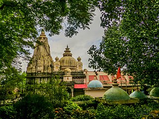
Central Railway is one of the 19 zones of Indian Railways. Its headquarters is in Mumbai at Chhatrapati Shivaji Maharaj Terminus. It has the distinction of operating the first passenger railway line in India, which opened from Mumbai to Thane on 16 April 1853.
<span class="mw-page-title-main">Palghar</span> Town in Maharashtra, India

Palghar is a town in the Konkan division of Maharashtra state, India and a municipal council. It is in the Mumbai Metropolitan Region, and since 2014 it has been the administrative capital of the Palghar district. Palghar lies on the Western Line of the Mumbai Suburban Railway in the busy Mumbai-Ahmedabad rail corridor. The town is located about 87 kilometers north of Mumbai, about 35 kilometers north of Virar and about 24 kilometers west of the Mumbai-Ahmedabad National Highway at Manor.

<span class="mw-page-title-main">Narayangaon</span> Town in Maharashtra, India

Narayangaon is a town in the Junnar taluka of the Pune district of Maharashtra state, India. Water is abundant because of its proximity to the major dams, the western ghats, and the Sahyadri mountain range.

<span class="mw-page-title-main">Wai, Maharashtra</span> Town in Maharashtra, India

Wai is a town in Satara district of Maharashtra state in India. Located on the Krishna River, Wai was a prominent town during the Peshwa era. Two important Marathi Brahmin from ruling families had their origins here: Rani Lakshmibai of Jhansi and Gopikabai, wife of Nanasaheb Peshwa.

<span class="mw-page-title-main">Bhandardara</span> Village in Maharashtra, India

Bhandardara is a holiday resort village near Igatpuri, in the western ghats of India. The village is located in the Akole tehsil, Ahmednagar district of the state of Maharashtra, about 185 kilometers (115 mi) from Mumbai, 155 kilometers (96 mi) from Ahmednagar and 73 kilometers (45 mi) from Nashik.

Kalyan taluka is a taluka of the Thane district of Maharashtra in Konkan division. It is located between 19°4' and 19°24'N. and 73°1' and 73°24'E with an area of 276 square miles (710 km2). The capital is the city of Kalyan.

Murbad is one of the 288 Vidhan Sabha constituencies of Maharashtra state, western India. This constituency is located in Thane district.

Kalyan East Assembly constituency is one of the 288 Vidhan Sabha constituencies of Maharashtra state, western India. This constituency is located in Thane district.

Bhiwandi taluka is a taluka in Thane district of Maharashtra in Konkan division. It contains the city of Bhiwandi.

Thane taluka is a taluka in Thane district of Maharashtra state in Konkan division.

Ulhasnagar taluka is a taluka in Thane district of Maharashtra in Konkan division.

<span class="mw-page-title-main">Ambarnath taluka</span>

Ambernath taluka is a taluka in Thane district of Maharashtra in Konkan division. Ambernath taluka consist cities like Ambernath and Badlapur.

Murbad taluka is a taluka in Thane district of Maharashtra in Konkan division.

Shahapur taluka is a taluka in Thane district of Maharashtra in Konkan division.

Bhadane is a village in the Murbad taluka of Thane district in Maharashtra, India.

<span class="mw-page-title-main">Gorakhgad</span>

Gorakhgad Fort is a fort located 24 km from Murbad, Thane district, of Maharashtra. This fort is an important fort in Thane district. This fort was mainly used by sadhus or hermits for meditation.and also by local people's of surrounding village, It was also used to guard the ancient trade route passing through Naneghat.

References

  1. 1 2 Falling Rain Genomics, Inc - Murbad
  2. List of villages in Murbad
  3. N/A, N/A. "Climate: Murbad". climate-data.org. Retrieved 4 December 2016.
  4. "Census of India 2001: Data from the 2001 Census, including cities, villages, and towns (Provisional)". Census Commission of India. Archived from the original on 16 June 2004. Retrieved 1 November 2008.
  5. "Mhasa Yatra – Strolling The Ancient Indian Fair". Ghumr - a travel blog. Rupali Gurav.