Palaspe

Last updated

Palaspe
village
Coordinates: 19°00′N73°06′E / 19°N 73.1°E / 19; 73.1 Coordinates: 19°00′N73°06′E / 19°N 73.1°E / 19; 73.1
CountryFlag of India.svg  India
State Maharashtra
District Raigad district
Languages
  Official Marathi
Time zone IST (UTC+5:30)
PIN 410206 [1]
Telephone code 02143
Vehicle registration MH 46
Nearest city PANVEL

Palaspe is located in near Panvel in Raigad district in Maharashtra, India.

Panvel Nodal City of Navi Mumbai in Maharashtra, India

Panvel is a locality in Raigad district of Maharashtra in Konkan Division, and is a node of Navi Mumbai city. It is highly populated due to its closeness to Mumbai. Panvel is located in the Mumbai Metropolitan Region. Panvel is the first Municipal Corporation in Raigad and the 27th Municipal corporation of Maharashtra State.

Raigad district District of Maharashtra in India

Raigad District is a district in the state of Maharashtra, India. Formerly called the Kolába district, the district was renamed Raigad, after the fort that was the first capital of the former Maratha Empire, which in turn was renamed from its earlier name - Rairi. The fort is located in the interior regions of the district, in dense forests on a west-facing spur of the Western Ghats of Sahyadri Range. In 2011 the district had a population of 2,635,394, compared to 2,207,929 in 2001. The name was changed in the regime of Chief Minister Antule on 1st Jan 1981. In 2011 urban dwellers had increased to 36.91% from 24.22% in 2001.

Maharashtra State in western India

Maharashtra is a state in the western peninsular region of India occupying a substantial portion of the Deccan plateau. It is the second-most populous state and third-largest state by area in India. Spread over 307,713 km2 (118,809 sq mi), it is bordered by the Arabian Sea to the west, the Indian states of Karnataka and Goa to the south, Telangana and Chhattisgarh to the east, Gujarat and Madhya Pradesh to the north, and the Indian union territory of Dadra and Nagar Haveli to the north west. It is also the world's second-most populous subnational entity. It was formed by merging the western and south-western parts of the Bombay State, Berar and Vidarbha, and the north-western parts of the Hyderabad State and splitting Saurashtra by the States Reorganisation Act. It has over 112 million inhabitants and its capital, Mumbai, has a population around 18 million making it the most populous urban area in India. Nagpur hosts the winter session of the state legislature. Pune is known as 'Oxford of the East' due to the presence of several well-known educational institutions.

Details

The town lies on Mumbai Goa National Highway (NH 4) and NH 17. The nearest Town and Rail Head is Panvel. The nearby places around Palaspe includes Karnala fort, Shirdhon, Karnala Bird Sanctuary. It has a Dhrupad gurukul.

National Highway 4 or NH 4, It is of 230.7 km of length. This highway is known as Andaman Trunk Road

Shirdhon village in Maharashtra, India

Shirdhon is a small village located in near Panvel in Raigad district in Maharashtra, India. It lies on Mumbai Goa National Highway NH 17. The nearest Town and Rail Head is Panvel. Karnala fort and Karnala Bird Sanctuary are just 4 km away from Shirdhon. Shirdhon is having a village panchayat. Rice is the main agriculture over here.

Karnala Bird Sanctuary

The Karnala Bird Sanctuary is located in Panvel Taluka of Raigad District, outside Mumbai, India near Matheran and Karjat. The sanctuary is quite small with an area of 12.11 square kilometres but along with the Sanjay Gandhi National Park and Tungareshwar sanctuary is one of the few sanctuaries to be within reach of the city of Mumbai.

The National highway No. 17 (NH 17) starts near Palaspe. The place is called as Palaspe phata. The highway passes through Goa till Kochi. [2]

Goa State in India

Goa is a state on the southwestern coast of India within the region known as the Konkan, separated from the Deccan highlands of the state of Karnataka by the Western Ghats. It is bounded by Maharashtra to the north and Karnataka to the east and south, with the Arabian Sea forming its western coast. It is India's smallest state by area and the fourth-smallest by population. Goa has the highest GDP per capita among all Indian states, two and a half times that of the country. It was ranked the best-placed state by the Eleventh Finance Commission for its infrastructure and ranked on top for the best quality of life in India by the National Commission on Population based on the 12 Indicators.

Kochi Metropolis in Kerala, India

Kochi, also known as Cochin, is a major port city on the south-west coast of India bordering the Laccadive Sea. It is part of the district of Ernakulam in the state of Kerala and is often referred to as Ernakulam. Kochi is the most densely populated city in Kerala. As of 2011, it has a corporation limit population of 677,381 within an area of 94.88 km² and a total urban population of more than of 2.1 million within an area of 440 km², making it the largest and the most populous metropolitan area in Kerala. Kochi city is also part of the Greater Cochin region and is classified as a Tier-II city by the Government of India. The civic body that governs the city is the Kochi Municipal Corporation, which was constituted in the year 1967, and the statutory bodies that oversee its development are the Greater Cochin Development Authority (GCDA) and the Goshree Islands Development Authority (GIDA).

JNPT port is close to Palapse, 25 km away. With this, most of the farms and places in the village are occupied by container yards.

Related Research Articles

New Panvel Node in Maharashtra, India

New Panvel is a residential, commercial and educational node of Navi Mumbai in city of Panvel, Maharashtra and comes under the Konkan division. New Panvel was developed on marshy land and was previously a Mango cultivated area. New Panvel is divided into two parts: New Panvel (E), on the eastern side of Panvel railway station and Khanda Colony or New Panvel (W) on the western side of it. Both parts of New Panvel are connected by a flyover bridge also known as Khanda Colony Flyover. New Panvel (W) is also popularly called Khanda Colony by the local villagers, as the city is adjacent to two small villages Dhakta Khanda and Motha Khanda.

Neral, India Town in Maharashtra, India

Neral is a town in Raigad district in the Indian state of Maharashtra. It is 83 km from Mumbai-South and 42 km from Panvel in the Karjat tehsil. It is a rapidly developing city of a Raigad district which is well connected to Panvel, Mumbai, Thane and Pune. Neral along with Karjat is also known as Eastern Mumbai District.

Mahad City & Sub-district in Maharashtra, India

Mahadpronunciation  is a town in Raigad district(formerly Kulaba district) situated in the North Konkan region of Maharashtra state, India. It is located 108.5km from District's Headquarter Alibag, and 167km from Mumbai state capital of Maharashtra and Economic capital of India, towards Western Coast.

Chiplun a Town and a Tehsil in Maharashtra, India

Chiplunpronunciation  is a city and a tehsil in Ratnagiri district in the state of Maharashtra, India. It is the headquarter of Chiplun taluka and located on the Mumbai–Goa highway (NH-66) in western India. The city is about 320 km south of Mumbai in the Konkan region of Maharashtra. It is a fast developing city in Konkan with a strong cultural background. The name Chiplun means "The abode of Lord Parshuram."

Hosabettu village in Karnataka, India

Hosabettu is a census town in Dakshina Kannada District in the Indian state of Karnataka. It is located near Moodbidri and Mangalore coming within limits Karnataka state.

Rasayani Town in Maharashtra, India

Rasayani is located on SH-83, about five kilometres off NH4. Rasayani is composed of a cluster of villages namely Posari, Ambivali, Dapivali, Mohopada, Chambarli, Waveghar, Rees, kambe, Karade, Gulsunde, Turade, Sawle,. Apparently, the name Rasayani was originally coined by the noted Marathi writer P.L.Deshpande. There are many chemical manufacturing and processing companies located here. The word "Rasayan - रसायनी" means Chemical and India's first Chemicals industry "Hindustan Organic Chemicals Ltd." was established here in 1960's, hence he decided to name the place "Rasayani". It derives its name mainly from chemical industry HOCL. As of today the biggest player remaining is Reliance, which has a petrochemicals and fibre plant in the area.

Asian Highway 47 (AH47) is a route of the Asian Highway Network, running 2,124 kilometres (1,320 mi) from AH43 in Gwalior, India to AH43 in Bangalore, India.It passes through the Indian cities of Gwalior (AH43), Dhule (AH46), and Thane, Mumbai, Pune, Belagavi, Hubballi and Bangalore (AH43).

Tarkarli Tourist Place in Maharashtra, India

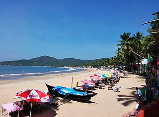
Tarkarli is a village in Malvan taluka in Sindhudurg district in the Indian state of Maharashtra. It is tourist destination and a coral beach. Ramnavmi is celebrated every year in Mahapurush Temple of the village.

Banda, Maharashtra town in Maharashtra, India

Banda is a town in Sindhudurg district in Maharashtra, India, near the Goa-Maharashtra border. Banda is the last town in Mahrashtra state on Mumbai-Goa national highway (NH-17), on the bak of the Terekhol river.

Karnala Fort

Karnala fort is a hill fort in Raigad district about 10 km from Panvel city. Currently it is a protected place lying within the Karnala Bird Sanctuary. It was a fort of strategic importance as it overlooked the Bor pass which connected the Konkan coast to the interior of Maharashtra and was the main trade route between these areas.

Sion Panvel Highway

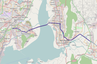
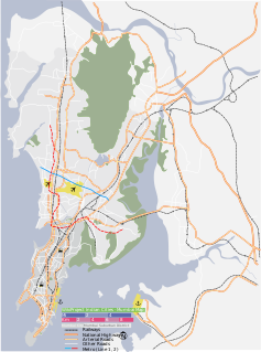
The Sion Panvel Expressway is a 25 km Indian highway located entirely in the state of Maharashtra, that connects Sion in Mumbai with Panvel, via Navi Mumbai. It is one of the busiest and most important roads in the Mumbai Metropolitan Region (MMR), and connects Mumbai with the city of Pune. The National Highway 4 and Mumbai Pune Expressway begin at the eastern end of the expressway, at Kalamboli junction, near Panvel. The highway is also used by vehicles traveling towards Mumbai from Konkan and Goa.

Kadekodi is a small village situated on the National Highway 17 (NH17) on the way from Honnavar to Kumta. Kadekodi is part of Kumta Taluk, Uttara Kannada district, Karnataka State

National Highway 66, commonly referred to as NH 66, is a busy National Highway that runs roughly north–south along the western coast of India, parallel to the Western Ghats. It connects Panvel to Kanyakumari, passing through the states of Maharashtra, Goa, Karnataka, Kerala and Tamil Nadu.

National Highway 748 (India) national highway in India

National Highway 748 is a National Highway in India that starts from Belgaum in Karnataka and ends at Panaji in North Goa district. The highway is 153 km (95 mi) long, of which 82 km (51 mi) is in Karnataka and 71 km (44 mi) is in Goa. It is a spur road of National Highway 48.

National Highway 348, commonly called NH 348 is a national highway in India. It is a spur road of National Highway 48. NH-348 traverses the state of Maharashtra in India.

National Highway 48 (India)

National Highway 48 is a National Highway of India that starts at Delhi and terminates at Chennai and goes through Jaipur, Udaipur, Ahmedabad, Surat, Mumbai, Pune,Tumakuru, Bengaluru and Vellore traversing through six states of India. It has a total length of 2807 km.

National Highway 748AA, commonly referred to as NH 748AA is a national highway in India. It is a spur road of National Highway 48. NH-748AA traverses the states of Karnataka and Goa in India.

References

  1. Pincode
  2. NH17