Hingoli district is an administrative district in the state of Maharashtra in India. The district headquarters are located at Hingoli. The district occupies an area of 4,526 km² and has a population of 11,77,345 of which 15.60% were urban. Hingoli was actually known as the Nizams military base as it was bordered with Vidharbha. In that era military troops, hospitals, veterinary hospital were in operation from Hingoli. Being a military base the city was one of the important and famous places of the Hyderabad state.One of the twelve Jyotirlinga shrines, the Aundha Nagnath is located in Hingoli district about 25 km south-west from district headquarter.

Jalna district is an administrative district in the state of Maharashtra in western India. Jalna town is the district headquarters. The district is part of Aurangabad division.
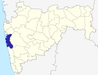
Osmanabad district is an administrative district in the Marathwada region in the Indian state of Maharashtra.The district headquarter is located at Osmanabad. This primarily rural district occupies an area of 7569 km² of which 241.4 km² is urban and has a population of 1,660,311 of which 16.96% were urban.

Beed is a city in central region of Maharashtra state in India. It is the administrative headquarters in Beed district.

Saphale is a town in Palghar Taluka in Palghar District in Maharashtra, India, north of the mouth of the Vaitarna River. According to Census 2011 information the location code or village code of Saphale village is 552293. Saphale village is located in Palghar Tehsil of Thane district in Maharashtra, India. It is situated 20km away from sub-district headquarter Palghar and 65km away from district headquarter Thane. As per 2009 stats, Saphala is the gram panchayat of Saphale village.

Multai is a town and a Nagar Palika in Betul district in the Indian state of Madhya Pradesh. Multai is one of the southern cities of Madhya Pradesh, occupying almost half of the Satpura plateau. Considering the small villages around, it occupies a large area in width of the Satpura range between the valley of the Narmada on the north and the bearer plains on the south. Forests lie to the west of the city between the districts of East Nimar and Amaraoti. It lies on the Northern bank of the Tapti.
Nilanga is a town with a municipal council in Latur District in the Indian state of Maharashtra. It is also the headquarters for Nilanga Taluka. The city being small is the Taluka Headquarter.
Umarga is a town with a municipal council in the Osmanabad district in the Indian state of Maharashtra.
Wadwani or Wadvani is a tehsil in Majalgaon subdivision of Beed district in the Indian state of Maharashtra.
Kavathe-Mahankalpronunciation (help·info) is a tehsil in Miraj subdivision of Sangli district in the Indian state of Maharashtra. This is famous for Mahankali Devi temple and Mallikarjun Temple. There is also a Sugar Factory, named after the same Goddess Mahankali Sugar Factory.
Vadhav is a village in the tehsil/mandal of Pen in the Raigad district of Maharashtra.
Latur Taluka is a taluka of Latur District in Maharashtra, India. In the 2011 census, there were 109 panchayat villages in Latur Taluka. The main river in the taluka is the Manjara River, together with its tributary the Tawarja, which originates near Murud. Latur city is the headquarter of the Latur taluka.
Sonkhed is a village in Loha taluka of Nanded district in Maharashtra state of India.

Tourism in Marathwada refers to tourism in Marathwada region of Maharashtra state of India. Aurangabad city is a regional headquarter of Marathwada and tourism capital of Maharashtra state. Out of 4 UNESCO World Heritage Sites in Maharashtra, 2 of them are in Marathwada. Also there are 110 monuments in Marathwada which are protected by Government of Maharashtra and recognized by Archaeological Survey of India. Marathwada is also important region for Religious tourism, out of 12 Jyotirlingas of Hindu God Shiva, 3 are in Marathwada. Hazur Sahib Nanded is the second holiest place in Sikhism after Harminder Sahib of Amritsir. There are also sufi shrines in Marathwada, most famous among them is Turabul Haq Dargah at Parbhani where thousands of people of all religion visits dargah annually. Pathri in Parbhani district is birthplace of Sai Baba of Shirdi and Sai Baba Birth Temple in Pathri is one of major religious tourism place in Marathwada.
Sonesangavi is a village in Beed district, Maharashtra state, India. It is situated 17 km away from sub-district headquarter (Taluka) Kaij and 76 km away from district headquarter (District) Beed. It belongs to Marathwada region and Aurangabad division. Its altitude is 674 meter above sea level. As per 2009 stats, Sonesangavi is the gram panchayat of Sonesangavi village. According to Census 2011 information the location code or village code of Sonesangavi village is 559769. Telephone std code for the village is 02445.
Pusane is a village in India. It is situated in the Mawal taluka of Pune District in the state of Maharashtra.
Pilode is a village is located in Amalner Tehsil of Jalgaon district in Maharashtra, India. It is situated 10 km away from sub-district headquarter Amalner and 65 km away from district headquarter Jalgaon.
Devthana is a village located in Dharur tehsil of Beed district. It belongs to Majalgaon constituency of Maharashtra legislative assembly.
Adgaon Kh, is a small village in the Indian state of Maharashtra. Adgaon Kh village is 548898. It is located in Aurangabad Tehsil of Aurangabad district, Maharashtra, India.